SPC's Tropical Connection
 |
| A one-kilometer-resolution image of Hurricane Rita on the afternoon of September 21, 2005, as it intensified into a Category 5 storm. Courtesy of NASA's MODIS Rapid Response Team. (large image, resize your window) |
At 2309Z on September 21, 2005, aircraft reconnaissance reported that a dropwindsonde released into the eye of Hurricane Rita measured a central pressure of 899 mb. Based on this measurement and other factors, forecasters at the National Hurricane Center adjusted the minimum pressure down to 897 mb (here's the 11 P.M. discussion from the National Hurricane Center). Using pressure as the sole criterion, this barometric estimate made Rita the third most powerful storm ever observed in the Atlantic basin.
As you will learn (or have already learned) in Meteo 241, most landfalling hurricanes spawn tornadoes, particularly those coming ashore along the Gulf and Southeast Coasts. In light of this proclivity for twisters to spin-up as hurricanes come ashore, the Storm Prediction Center routinely issues tornado watches (check out the obligatory tornado watch for Hurricane Rita). For more information regarding watches, check out SPC's primer).
Lest you walk away with the impression that tornadoes only occur near the immediate coastline as hurricanes make landfall, I offer SPC's storm reports on September 24, 2005 (the day after Rita came ashore) as a counterexample. Note the gaggle of tornado reports relatively far inland mostly to the east of Rita's path (check out the storm's path and compare it to the location of tornado reports).
 |
| The Storm Prediction Center issued tornado watch #809 early on September 23, 2005, as Hurricane Rita approached from the Gulf of Mexico. Here are the corresponding radar/watch-box and warnings/watch-box graphics. |
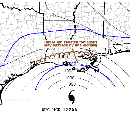
Students enrolled in the summer semester should also be aware that SPC issues mesoscale discussions for landfalling hurricanes and tropical storms (check out the description of this product). The image and partial text below accompanied Mesoscale Discussion #2256 issued by SPC as Hurricane Rita approached land (there may be references in this "MD" that you don't fully understand; remain calm - all in good time).
|
TRENDS ARE BEING MONITORED FOR INCREASING SEVERE THREAT. A TORNADO
WW COULD BECOME NECESSARY ACROSS PARTS OF THE WEST CENTRAL GULF
COAST AS EARLY AS THE 15-18Z TIME FRAME.
CENTER OF RITA CONTINUES ITS SLOW WEST NORTHWEST MOTION AND IS NOW ROUGHLY 180 MI SOUTH SOUTHWEST OF HOUMA LA. OBJECTIVE ANALYSIS AND VAD WIND DATA SUGGEST BROAD BELT OF STRONGER CYCLONIC LOW-LEVEL FLOW ON ITS EASTERN/NORTHERN PERIPHERY IS ALREADY OVERSPREADING CENTRAL GULF COASTAL AREAS. LOW-LEVEL SHEAR HAS BEEN SUPPORTIVE OF TORNADO POTENTIAL FOR SOME TIME NOW...AND WITH DAYBREAK...LOW-LEVEL THERMODYNAMIC STRUCTURE SHOULD BEGIN TO BECOME INCREASINGLY FAVORABLE FOR TORNADIC DEVELOPMENT IN OUTER CONVECTIVE BANDS. SUBSTANTIAL CLOUD COVER MAY SLOW BOUNDARY LAYER HEATING. |
 |
| The graphic and partial text of Mesoscale Discussion #2256 (full text), which discussed SPC's thinking about the mounting threat of tornadoes as Hurricane Rita approached landfall. In real time, you can access the mesoscale discussion graphics by clicking on the corresponding national map. |
©1999-2004 The Pennsylvania State University. All rights reserved.