Several factors prompted the U.S. Census Bureau to create the TIGER database. One was the need to conduct the census by mail. As the population of the U.S. increased, it became impractical to have census takers visit every household in person. Since 1970, the Census Bureau has mailed questionnaires to most households with instructions that completed forms should be returned by mail. In 1990, 63 percent of questionnaires were completed and returned. About two thirds of questionnaires were returned in 2000.
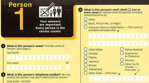
Portion of the official questionnaire used in the Census 2000 Dress Rehearsal.
TIGER depends on a Master Address File (MAF), a complete inventory of housing units in the U.S., Puerto Rico, and associated island areas. The MAF includes postal (street) addresses, or descriptive addresses, for over 100 million households. Unfortunately, for the purposes of the Census Bureau, postal addresses do not adequately specify exact geographic locations. An address is not a position in a coordinate system--it is only one in a series of positions along a route. The location of an address is often ambiguous because street names are not unique, numbering schemes are inconsistent, and because routes have two sides, left and right. Location matters, as you recall, because census data must be accurately georeferenced to be useful for reapportionment, redistricting, and allocation of federal funds. Thus, to conduct the census by mail, the Census Bureau had to find a way to assign address referenced data automatically to particular census blocks, block groups, tracts, voting districts, and so on. That's what the "Geographic Encoding and Referencing" in the TIGER acronym refers to.
A second motivation that led to TIGER was the need to help census takers find their way around. Millions of households fail to return questionnaires by mail, after all. Non-responding households must be interviewed by census takers in person. Census takers need maps showing streets and select landmarks to help locate households. Census supervisors need maps to assign census takers to particular territories. In fact, some 1.1 million unique map sheets were used to conduct the 1990 census.
Prior to 1990, the Bureau relied on local sources for its maps. For example, 137 maps of different scales, quality, and age were used to cover the 30-square-mile St. Louis area during the 1960 census. The need for maps of consistent scale and quality forced the Bureau to become a map maker as well as a map user.
The Census Bureau's mission is not only to collect data, but also to make data available to its constituents. In addition to the attribute data considered in the Chapter 3, the Bureau produces a variety of geographic data products, including wall maps, atlases, and one of the earliest on-line mapping services, the TIGER Mapping Service. You can explore the Bureau's maps and cartographic data products at http://www.census.gov/geo/www/maps/
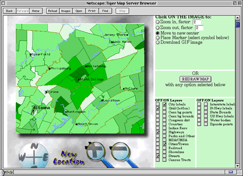
Launched in 1995, the TIGER Mapping Service was one of the earliest Internet map services. Registered students will use its successor, American Factfinder, in Project 2.