The Census Bureau began to develop a digital geographic database of 144 metropolitan areas in the 1960s. By 1990, the early efforts had evolved into a seamless geographic database that covers the whole of the United States and its territories. TIGER/Line files are digital map data extracted from the TIGER database. Features and attributes included in TIGER/Line files include:
| Vector Features | Attributes |
| Roads | Address ranges ZIP Codes Road type Name |
| Railroads | Type Name |
| Hydrography | Type Name |
| Miscellaneous ground transportation | Type (e.g. pipeline, Power line, etc.) Name |
| Nonvisible features | Type (e.g., administrative boundary) Geographic entity code |
| Select point landmarks | Type (e.g. school, church) Name |
| Select area landmarks | Type (e.g., park, cemetery) Name |
Note that TIGER/Line files do not include the census data collected through questionnaires and by census takers. TIGER provides the geographic framework within which census data are organized, analyzed, and reported.
TIGER/Line files embody the vector approach to representing geographic phenomena. The landmarks, roads, statistical areas, and other entities represented in the files are encoded as landmark points, nodes, chains, and polygons as shown in the diagram below.
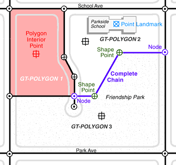
Vector features in TIGER/Line files. (U.S. Census Bureau 1997).
The diagram illustrates the various types of point, line, and area features used to represent a city block. Landmark points represent the locations of schools, churches, transportation terminals, and other structures that help census takers to orient themselves in the field. Point features are "0-dimensional," consisting only of a single pair of latitude and longitude coordinates. 1-dimensional line features called chains are used to represent streets. Chains begin and end with point features called nodes. Nodes also occur where chains intersect. Chains may be subdivided into segments marked with shape points, which merely define the curvature of a chain. A closed sequence of chains forms a polygon, the 2-dimensional geometric primitive used to represent entities like blocks, counties, and voting districts. Every polygon contains a polygon interior point with which names and other attributed information can be associated. The fundamental polygonal unit from which all other polygons are assembled is the "GT" polygon. "GT" stands for "geometry and topology." We'll look into topology in the following page.
Until recently the geometric accuracy of the vector features encoded in TIGER were notoriously poor (see illustration below). Through 2003, the TIGER/Line metadata (see http://www.census.gov/geo/www/tlmetadata/metadata.html) stated that
Coordinates in the TIGER/Line files have six implied decimal places, but the positional accuracy of these coordinates is not as great as the six decimal places suggest. The positional accuracy varies with the source materials used, but generally the
information is no better than the established National Map Accuracy standards for 1:100,000-scale maps from the U.S.
Geological Survey (Census Bureau 2003)
| Try this |
Having performed scale calculations in Chapter 2 you should be able to calculate the magnitude of error (ground distance) associated with 1:100,000-scale topographic maps. Recall that the allowed error for USGS topographic maps at scales of 1:20,000 or smaller is 1/50 inch (see http://nationalmap.gov/gio/standards/) |
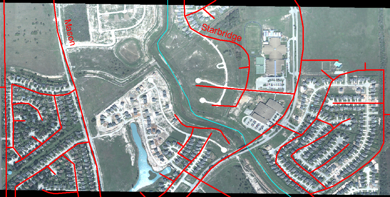
Discrepancy between TIGER/Line file streets (red) and actual geometry of street network shown in an orthorectified aerial image (U.S. Census Bureau n.d).
Starting in 2002, in preparation for the 2010 census, the Census Bureau commissioned a six-year, $200 million effort to modernize TIGER. One objective of the effort is to use GPS to capture accurate geographic coordinates for every household in the MAF. The project also involves improving the accuracy of TIGER's street features. The objective is to adjust the geometry of street networks to align within 7.6 meters of street intersections observed in orthoimages or measured using GPS. The corrected streets are necessary not just for mapping, but for accurate geocoding. Because streets often form the boundaries of census areas, it is essential that accurate household locations are associated with accurate street networks.
| Practice Quiz |
Registered Penn State students should return now to the Chapter 4 folder in ANGEL (via the Resources menu to the left) to take a self-assessment quiz about TIGER. You may take practice quizzes as many times as you wish. They are not scored and do not affect your grade in any way. |
 |
Students who register for this Penn State course gain access to assignments and instructor feedback, and earn academic credit. Information about Penn State's Online Geospatial Education programs is available at http://gis.e-education.psu.edu. |