In the context of digital geographic data, the term topology refers to the relative locations of spatial features. Absolute locations in recent TIGER/Line files are encoded with geographic coordinates (latitude and longitude) based on the NAD 83 datum. Relative locations are specified in terms of relationships between features, such as connectivity, adjacency, and containment. For example, the street I live on, Cherry Ridge Road, connects with Berkshire Road on both ends. Cherry Ridge Road forms the boundary of two adjacent blocks, one on the north side of the street and one on the south side. TIGER gets its name in part from the fact that topological relationships such as connectivity and adjacency are encoded explicitly in the database.
One way accurate topology benefits Census Bureau operations is by assuring that census data will be associated correctly with census geographies. Recall that one of the main purposes of the decennial census is to provide the data needed for reapportionment and redistricting. Household data must be aggregated to various geographic areas, including blocks, tracts, and voting districts. To automatically associate address-referenced data with a geographic area, the database has to know which side of the street the household is located on, and which geographic area is adjacent to the street on that side. In other words, the database needs to include topology.
How does the database know which is the left side of a street and which is the right? The left and right sides of a chain are defined in relation to the low to high sequence of street addresses. In the U.S. and other parts of the world, street addresses usually progress in numerical order, with odd numbered addresses generally on one side of the street and even numbers on the other side. (That's not true everywhere, however. In older Japanese cities, for example, addresses indicate the age, not the relative location, of a building). If we start at the lowest numbered address and move along a street toward the highest address, we can say that the street has a left side and a right side. By the same reasoning, we can say that the series of vector line segments that represent the street each begin with a from node and end with a to node. Having established from and to nodes, we can then specify which polygons (that represent city blocks) are adjacent to each street segment on the right and left side. That's how topology is encoded in TIGER.
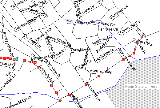
A selected chain in a TIGER/line file is highlighted in the LandView III program.
A portion of an early TIGER/Line file for Centre County, Pennsylvania is shown above. Notice that all the nodes and shape points that make up one street, Circleville Road, are highlighted (the nodes and points appear as red squares). I used a software program called LandView III to plot the TIGER/Line file. (LandView IV is available from the Census Bureau at http://www.census.gov/geo/landview/lv4page.html). Also notice the rather jagged shapes of the streets. The early editions of TIGER/Line files, at least, were more accurate topologically than geometrically. This was acceptable, given their primary intended use--which was to correctly assign census data to census areas and voting districts.
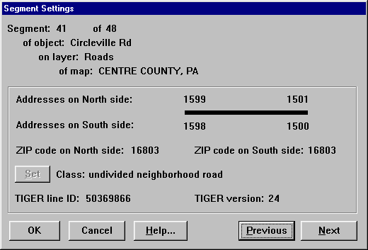
LandView III's "Segment Settings" dialog box displays the attributes and topology of a selected line segment.
LandView III enables you to look up some of the topological relationships and address range attributes of line segments that represent streets. The "Segment Setting" dialog box above reports characteristics of one segment, segment 41, of the chain of segments used to represent Circleville Road. Notice the buttons labeled "Previous" and "Next" in the lower right corner of the dialog. These allow you to traverse the chain of line segments. This is possible because the connectivity of segments is explicitly encoded in the data.
The Segment Settings dialog box also displays the range of addresses and ZIP Code attributes associated with the "North side" and "South side" of the line segment. Although the address ranges are encoded relative to from and to nodes, the LandView software reports the attributes relative to the cardinal directions for easier map interpretation.
The "TI" in TIGER stands for "topologically integrated." This simply means that relationships between all categories of vector features are specified. Different categories of features, such as those that represent roads and streams and boundaries, are not stored in separate data layers as they might be in a CAD drawing file.