When census takers ("enumerators" in Census speak) visit households in person, they can record the location of each household on a field map or with a GPS receiver. Later they can use their field notes and GPS coordinates to assign the census data they collect to the correct census blocks, tracts, and voting districts. Enumerators may never visit households that fill out and return questionnaires by mail, however. Consequently, TIGER was created to match addressed-referenced data to locations automatically, a task known as geocoding.
If TIGER and MAF included accurate coordinate locations for every household, and correspondingly accurate streets and administrative boundaries, geocoding census data would be simple (conceptually, at least). Many local governments digitize locations of individual housing units when they build geographic information systems for E-911 dispatch and other purposes. The MAF/TIGER modernization project begun in 2002 aims to accomplish this in time for the 2010 census. The illustration below shows properly aligned TIGER streets, shorelines, and individual household locations in relation to an orthorectified aerial image. Through 2000, however, national coverage at this level of detail and accuracy remained a dream. And even after the goal is achieved, coordinate locations of individual housing units in TIGER will remain confidential.
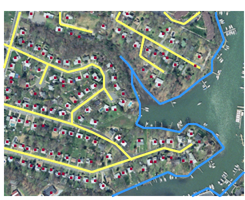
Intended accuracy and completeness of modernized TIGER data in relation to the real world. TIGER streets (yellow), shorelines (blue), and housing unit locations (red) are superimposed over an orthorectified aerial image.(U.S. Census Bureau n.d.). National coverage of housing unit locations and geometrically-accurate streets and other features were not available in 2000 or before.
Instead of geographic coordinates for every address, TIGER/Line files include address ranges for both sides of most street segments. Users can estimate locations of individual addresses from the address ranges.
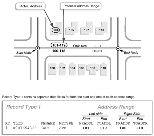
How address range attributes are encoded in TIGER/Line files. (U.S. Census Bureau 1997).
The diagram above shows how address ranges are encoded in TIGER/Line files. A line segment is used to represent one block of Oak Avenue. The segment is bounded by two nodes, labeled "Start" and "End." A corresponding record in an attribute table includes the unique ID number (0007654320) that identifies the segment, along with starting and ending addresses for the left (FRADDL, TOADDL) and right (FRADDR, TOADDR) sides of Oak Avenue. Note also that the address ranges include potential addresses, not just existing ones. This strategy ensures that the ranges will remain valid as new buildings are constructed along the street.
Kathryn Robertson, a GIS Technician with the City of Independence, Missouri (and a student in the Fall 2000 offering of this course) pointed out how important it is that start (or "from") nodes and end (or "to") nodes correspond with the low and high addresses in address ranges. "I learned this the hard way," she wrote, "geocoding all 5,768 segments for the city of Independence and getting some segments backward. When address matching was done, the locations were not correct. Therefore, I had to go back and look at the direction of my segments. I had a rule of thumb, all east-west streets were to start from west and go east; all north-south streets were to start from the south and go north" (personal communication).
Next you'll have a chance to use a TIGER/Line file to geocode your own (or adopted) U.S. address.