Module 4: Mountain Building, Obduction, and Tsunamis
Welcome to Module 4!
Welcome to Module 4!
Mountain Building, Obduction, & Tsunamis
Introducing Obduction
"No matter how sophisticated you may be, a large granite mountain cannot be denied—it speaks in silence to the very core of your being."
—Ansel Adams, The Spirit of the Mountains
Video: Introduction to Module 4 (1:29)
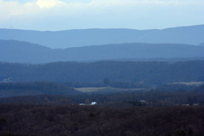
The Great Smokies are geologically attached to the whole Appalachian mountain range, including the ridges near Penn State’s University Park campus. There, if you’re so inclined, you can visit the beach in the mountains—all thanks to Africa.
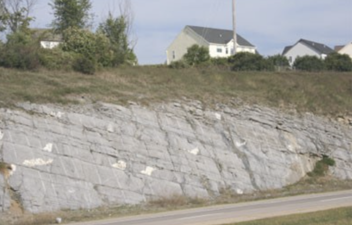
Dr. Richard B. Alley: We're up on Tussy Mountain not far from Penn State's University Park campus, in an old obduction zone. And this is an old beach. This is a Sandstone that was deposited on the edge of a sea when there was a mountain range being formed behind us. And what eventually turned into the giant collision when North America ran into Europe and Africa during the closing of the Proto-Atlantic.
Now you know about Beaches. They do not form like this, they form like this. But this one is now turned up on edge, like this. And what happened in the great collision is, there was a squeezing and sometimes the squeezing even broke, and then streams could get down in those cracks, and they could erode things, and they eroded way down to make a valley in the middle, which is where Penn State was founded. And now, the layers are sitting here like this. This particular layer goes way up. It's cut off. It comes back down and makes the top of Mount Nittany and then it comes back down, way on the other side, and makes Bald Eagle. And then it goes down and under rocks that are running off to the west of us. And people come up here and they go skiing and they go mountain biking and have a great time in this old obduction zone.
We saw in Module 3 that an old, cold sea floor is subducted beneath the warmer sea floor or a continent, but what happens when a high-floating continent or island arc tries to go down beneath another continent or island arc?
In this module, we’ll see that the answer is obduction, a BIG collision. The Great Smoky Mountains, Mt. Nittany near Penn State's University Park campus, and all the rest of the Appalachians were formed by just such a collision, between North America on one side, and Africa and Europe on the other side. Folding and thrust-faulting in the collision zone thickened and shortened the crust and upper mantle. This produced high mountains—probably about as tall as the Andes today. And, as we will discuss, high mountain peaks float on deep roots. When erosion lowers a mountain range, the root floats up, bringing metamorphic rocks to the surface that have been "cooked" by heat and pressure deep within the Earth.
Before we go any further, look at the following short video introduction by Dr. Anandakrishnan.
Video: Duck Mountain (2:23)
[RUNNING WATER]
Dr. Sridar Anandakrishnan: Oh, hi. Welcome to the GEOSC 10 Tectonics III Section, Mountain Building. We're going to be talking about how the Appalachians were built, and why they're still as high as they are now. And we're gonna talk a little bit about icebergs. Now, what does all that have to do with rubber duckies, and why am I in the bathtub surrounded by rubber duckies? Well, let's find out.
So why are we in a tub with rubber duckies? Imagine that these ducks represent the mountains that surround us right here in Happy Valley. This is Mount Nittany. Here's the Great Smoky Mountains. And these are all the ridges and valleys that spread up and down the east coast of North America known as the Appalachian Mountains.
About 300 million years ago, North America and what's now Europe and Africa all collided to form a supercontinent known as Pangaea. And when these continents collided, because they're both about the same density, neither one subducted beneath the other. In fact, as they crashed together, they formed larger and larger mountains that wrinkled up. And that's what we had 300 million years ago with the Appalachians. This big duck represents the mountains at the end of that mountain-building phase.
So after that collision, we have the proto-Appalachians. They were big. They were tall. They were high.
But for the last 300 million years, they've been eroded and eroded and eroded. But still, we have mountains around here that are a couple of thousands of feet high. If you go further down towards Tennessee and Kentucky, some mountains are 4,000 or 5,000 feet high. Why are they still high? Well, it has to do with buoyancy.
[RUNNING WATER]
And....A Word About Tsunamis
Plate tectonics causes earthquakes, volcanic explosions, and steep slopes that can experience landslides. If any of these happen under the ocean or in a deep lake, or if a landslide falls into an ocean or lake, a lot of water can be moved in a hurry. The resulting great waves are called tsunamis and can have catastrophic consequences. Fortunately, warning systems can be devised to reduce the loss of life, and we can use our knowledge to build in ways that increase safety for people and property. We'll look at some of these issues as we wrap up our multi-week exploration of Plate Tectonics and Mountain Building.
Learning Objectives
- Identify the push-together faults and folds formed in obduction zones when continents or island arcs collide.
- Explain the three basic tectonic styles: pull-apart, push-together, and slide-past.
- Explain how obduction zones can produce thickening of the crust that leads to the formation of metamorphic rocks.
- Explain how erosion can reveal metamorphic rocks formed in obduction zones.
- Explain how tsunamis are caused, and why they are dangerous.
What to do for Module 4?
You will have one week to complete Module 4. See the course calendar in Canvas for specific due dates.
- Take the RockOn #4 Quiz.
- Take the StudentsSpeak #5 Survey.
- Continue working on Exercise #2: Geology is All Around You.
Questions?
If you have any questions, send an email via Canvas, to ALL the Teachers and TAs. To do this, add each teacher individually in the “To” line of your email. By adding all the teachers, the TAs will be included. Failure to email ALL the teachers may result in a delayed or missed response. For detailed directions on how to do this, see How to send an email in GEOSC 10 in the Important Information module.
This course is offered as part of the Repository of Open and Affordable Materials at Penn State. You are welcome to use and reuse materials that appear on this site (other than those copyrighted by others) subject to the licensing agreement linked to the bottom of this and every page. Students who register for this Penn State course gain access to assignments and instructor feedback and earn academic credit. Information about registering for this course is available from the Office of the University Registrar.
Main Topics: Module 4
Main Topics: Module 4
Overview of the main topics you will encounter in Module 4.
Plate Tectonics III: Obduction
- In subduction, the denser side sinks under the less dense side.
- But the density of continents and island arcs is too low to allow them to go down very far — ”You can’t sink a continent”, as geologists like to say.
- Collisions involving continents and island arcs cause folding, push-together (thrust) faulting, and thickening of the crust and upper mantle.
- We call this OBDUCTION.
- Obduction generally makes the biggest mountain ranges, such as the modern Himalayas, and the Appalachians, which were much higher when they formed 200 million years ago than they are now.
- This push-together process sometimes pushes older rocks on top of younger ones.
A Little History—The closing of the proto-Atlantic Ocean and opening of the Atlantic
- Long ago, the Americas were separated from Europe and Africa by the proto-Atlantic Ocean (sometimes called the Iapetus Ocean).
- The proto-Atlantic Ocean shrank before disappearing, as subduction made large explosive volcanoes in island arcs that sometimes collided with one of the continents.
- The proto-Atlantic Ocean disappeared entirely in the great obduction that pushed up the Appalachians, including the Great Smoky Mountains and Mount Nittany near Penn State’s University Park campus.
- When the push-together motion ended, the huge pile of rocks that made the Appalachians was hot and soft down deep and began to spread under its own weight, with Death-Valley-type faulting and thinning of the crust and upper mantle.
- This thinning reduced pressure on the mantle beneath, which triggered convection there as hot rocks rose and melted, and thus led to the slow and still-occurring opening of the modern Atlantic Ocean.
The Three Basic Tectonic Styles
- PUSH-TOGETHER: subduction (Olympic, Crater Lake, Mt. St. Helens) or obduction (Great Smokies)
- PULL-APART: rifting/spreading/sea-floor-production (Death Valley)
- SLIDE-PAST: faulting (San Andreas)
- Intermediates can occur, such as a little push-together while sliding past, or a little pull-apart while sliding past.
- The three types of plate boundaries, plus hot-spot activity poking up through plates, create the great majority of mountain-building, earthquakes, volcanoes, etc.
Meanwhile, Out West:
- As the Atlantic Ocean opens, Asia and the Americas are approaching each other, narrowing the Pacific.
- Subduction under the western US started with cold rock, but as the continent moved toward the Pacific spreading ridge, more buoyant ("float-ier") rock was forced down, scraped along under the US rather than sinking deep, and rumpled up the lithosphere to make the Rockies, etc., far inland.
- Where the subduction zone has reached and swallowed the spreading ridge in the Pacific, rock is no longer going down under the western US; the subduction zone was push-together plus slide-past, and the slide-past remains as the San Andreas Fault.
- Where and when the push-together of the subduction ended, the pile of the western US spread under its weight, giving Death Valley-type faulting at Death Valley and across much of Nevada and nearby.
- (This may seem complex, but the full story is likely even more complex than this, and not all of it is fully known. This is close, though.)
Old Mountains and Metamorphism
- The upper layers of the Earth float on lower layers.
- When the collision of an obduction event thickens the upper, crustal rocks, the mountains sticking up into the air float on a root sticking down into the mantle (like an iceberg, but icebergs have about 1/10 sticking up and 9/10 sticking down, whereas mountains are closer to 1/7 up and 6/7 down).
- If you cut or melt off the top of an iceberg, the bottom bobs up; if you erode off the top of mountains, the bottom bobs up.
- Bobbing up of eroding mountains brings rocks to the surface that had been buried deeply, where they were heated and squeezed.
- Heating and squeezing turn sedimentary rocks (pieces of older rocks) or igneous rocks (frozen from melted rock) into metamorphic rocks, which often are pretty and may contain valuable ores or gems.
Tsunamis
- Undersea earthquakes, volcanoes, landslides, or meteorite impacts can move lots of water.
- Such water motion makes a wave (a tsunami) that is long and low in the ocean, but the wavefront slows down as it enters shallow water, and the back catches up and piles up.
- Most tsunamis are tiny, but the biggest ones can run up on land to elevations above 1000 feet; the 2004 Indian Ocean tsunami killed over 300,000 people, and the tsunami from the Tohoku, Japan earthquake in 2011 did much of the damage in what was probably the most expensive natural disaster ever.
- We know of no way to stop tsunamis, but we can give real-time warnings (earthquakes, etc., make seismic waves that go faster than tsunamis; we can “listen” for those seismic waves with seismometers, then warn people to go inland fast).
- We can enact and enforce zoning codes to build only in safe places, and keep reefs and barrier islands healthy to break some of the energy of tsunamis.
Still More Plate Tectonics, The Great Smoky Mountains
Still More Plate Tectonics, The Great Smoky Mountains
The Smokies--and State College?
As usual, we start with a little background on our featured National Park, this time The Great Smoky Mountain National Park of North Carolina and Tennessee. Then, we get into the material that might be on the RockOn Quiz, starting with the first virtual tour below and then discussing obduction zones. The Great Smokies include 16 mountains over 6,000 feet (about 2,000 m) high, making this generally the highest region in North America east of the Mississippi River. The tourist town of Gatlinburg is a mile (1.6 km) lower than Mt. Le Conte, a difference almost as large as in many of the great mountain parks of the west, where the peaks are higher but so are the valleys. The Smokies were preserved as a park in 1926, with much of the funding for land purchases provided by J.D. Rockefeller. The Great Smokies today are the most-visited National Park because they combine spectacular scenery, rich biological and historical diversity, proximity to major population centers, the lure of a quick stop-off on the drive from the northeast USA to Florida, and a shortage of other nearby national parks to draw off the crowds. (Although we should not forget Shenandoah National Park, which is connected to the Smokies by the Blue Ridge Parkway, another beautiful park.)
In case you’re interested (and no, you do not need to memorize these!), the National Park Service keeps track of visitation, and you can easily find the numbers by searching online. As this text was being written, the Blue Ridge Parkway was the most-visited “park” managed by the National Park Service, but if we restrict attention to the actual National Parks, the numbers of visitors for the most popular parks are outlined in the table below.
| National Park | Number of Visitors |
|---|---|
| Great Smoky Mountains | 14.1 million |
| Zion | 5 million |
| Yellowstone | 4.9 million |
| Grand Canyon | 4.5 million |
| Rocky Mountain | 4.4 million |
| Acadia | 4.0 million |
| Grand Teton | 3.9 million |
| Yosemite | 3.3 million |
| Indiana Dunes | 3.2 million |
Much interest in the Smokies centers on its historical aspects. For example, how did the early European settlers survive and flourish in this region? At Cades Cove, wonderful relics of a bygone lifestyle are maintained in a living museum. Many visitors are also seeking to learn about the earlier Native Americans. Biologically, the Smokies host an amazing array of tree species, flowering bushes (azaleas, rhododendrons, and mountain laurels, in particular), wildflowers (including many orchids), and more. Approximately one-third of the park is covered with "virgin" timber that escaped being cut by European settlers in the high, remote landscape, and the regions that were logged are growing back rapidly with impressive stands of diverse trees.
Abundant rainfall and snowfall “scraped” from the sky by the high peaks feed numerous cascades and waterfalls, with trout in the pools and kingfishers by their banks. Rainfall is roughly 50 inches (1.3 m) per year in the valleys and more than 85 inches (2 m) per year on the peaks, so the Smokies share some characteristics with temperate rainforests of the west such as in Olympic. Especially during “off-peak” times when fewer travelers are present, you can get lost in the Smokies, and imagine what the Appalachians must have looked like without humans; approximately 3/4 of the park is wilderness. And, because so many of the visitors are traveling by car and heading somewhere else, even a short walk down a trail can get you away from almost everyone.
To see a little of the park, and to get started on the key ideas that will be on the RockOn Quiz, join Dr. Alley and his team as they take you on a "virtual tour" of Great Smoky Mountain National Park that illustrates some of the key ideas and concepts being covered in Module 4.
Virtual Field Trip: Great Smoky Mountains
Join us as we go on a virtual tour of the. Great Smoky Mountains.
Obduction Zones: The Push-Together Boundaries
Obduction Zones: The Push-Together Boundaries
The Smokies are a small part of the great Appalachian Mountain chain, which extends along the coast of North America from Newfoundland through the Smokies, and then bends westward into Oklahoma. In the Great Smokies, the mountains display a truly remarkable feature—in some places, older rocks sit on top of younger rocks! The very high peaks are composed of hard, resistant, old metamorphic rocks (which we will explain soon), of the sort that one finds deep in a mountain range. Beneath them are younger, sedimentary rocks that were deposited in shallow seaways. Between these is a surface called a thrust fault or push-together fault. Thrust faults often show scratches that form when the rocks on one side of the fault slide past the rocks on the other side. Thrust faulting has been observed during earthquakes in some cases elsewhere in the world where push-together deformation is still active. In the Smokies, the older rocks have been shoved as much as 70 miles (110 km) to reach their present position on top of the younger rocks. The pictures below the video show two very much smaller thrust faults, with the upper rocks shoved up to the left only a few inches, but the idea is the same.
Video: Cades Cove (4:21)
Dr. Richard B. Alley: So this is a black bear walking down into Cades Cove in the Great Smoky Mountains National Park. The Smokies formed by obduction. They were formed in a great collision. And you know something about collisions. If this car worked before the Collision, it would have had a front that was fairly long horizontally and fairly short, thin vertically. But when it ran into the wall, you can see what happened. It got squeezed horizontally and thickened vertically. So it's shorter horizontally, thicker vertically. And this one did it by bending and getting squeezed and so on. In the Collision of the Great Smoky Mountains, there was some such bending. But, in addition, older rocks were shoved on top of younger ones, as shown in this diagram where the bear is walking, and we're gonna look at how that happened. First just a little geology terminology. Here's a pile of notebooks and things at our house. And to a geologist, you'd look at the one on the bottom and say that was put there first, it's been there longer, it's an older layer. And the one on the top was put there more recently, so that's a younger layer. Well now let's go to Glacier National Park, and this is a great cliff in Glacier, and we're going to zoom in on this cliff. And what we have here is a pile of layers, something like those notebooks. The one on the bottom is put down first, it's been there longer, it's an older layer. The one on the top was put there more recently, so it's a younger layer. But you'll also notice that if we follow this layer along, how do we find it? Well, we have to go up there, because there's been displacement here, the rocks were squeezed, and the squeeze broke the rocks, to make what we call a fault. And so you have this pile of rocks on both sides, but there's been some shoving going on. And we can put some labels on this to make it a little easy. On the left, you have the older at the bottom, and the younger on the top. On the right you have the older at the bottom and the younger at the top. But right here, notice what happens, the older is sitting on top of the younger. So now that allows us to go back and make sense of where the bear is. So here we are back at the bear, and he is walking through this diagram, with the older rocks on top of the younger. How did it get there? Well, let's do a simple diagram. Here it's older on the bottom, younger on the top, it gets squeezed by push-together stresses, and it's going to break along a fault like this. Okay, now faults sometimes move the rocks up a lot vertically and a little horizontally. The one at Glacier was pretty steep. The fault where the bear is moved mostly horizontally but with a little bit of vertical. And so it moved them a long way horizontal. So, I want you to focus on the "Y" in the younger layer and the "O" in the older layer, and when the fault breaks the O is going to go over by the Y, and you're going to pile it up like this. Well after that happened, after the fault broke, and it moved it like this, erosion happened, and it took down the surface, so it looked something like that, where the bear is. Or it looked like this diagram we've been looking at, or it looked like the bear. And so there we have push-together can bend things, it can squeeze them, but it can also shove older ones on top of younger ones so the bear can be walking on the younger rocks at Cades Cove in the Great Smokies.
You may recall that we started with pull-apart faults at Death Valley. As shown in the video above, thrust faults are of the push-together type. Squeezing from the sides caused one set of rocks to be pushed over another set. Each set is right-side up, but where they meet, the older rocks are on top of the younger ones. This is seen clearly in the Great Smokies.
Farther north, near Penn State’s University Park, Pennsylvania campus, where Drs. Alley and Anandakrishnan teach and where Dr. Alley wrote most of this material, we see a different way that rocks can respond to push-together stresses. There, in addition to some push-together thrust faults, many folds occur. Take a piece of paper, lay it on your desk, and squeeze the opposite sides towards the center. The paper will buckle into a fold. You may achieve the same effect by trying to push a carpet along the floor. Clearly, there are push-together forces involved here.
Watch this 1:38-minute video about the push-together thrust faults found in Capitol Reef National Park.
Video: Monocline Explained: Capitol Reef National Park (1:38)
[MUSIC PLAYING]
Dr. Richard B. Alley: We're at Capitol Reef National Park, home of the famous Waterpocket Fold. In the background, we can see it. This is a classic monocline, and it's a 100-mile-long flexure in the Earth's crust. And Dave's going to help show us how it formed.
This is the Earth's crust. And then 50 to 70 million years ago compressional stress came from the west and caused a bulge. And rocks on the west side were lifted up on along a thrust fault about 7,000 feet higher than rocks on the east side. Later, uplift during the uplift of the Colorado Plateau about 15 to 20 million years ago left it susceptible to erosion, and the top part was eroded off. And you got many of the geological features you'll find in the park, like monoliths, and canyons, and arches.
The reason the Waterpocket Fold got its name is when the younger layers up here were eroded, softer layers beneath were exposed, and formed small basins in which water gathered in, which provided a water source for early settlers.
[MUSIC PLAYING]
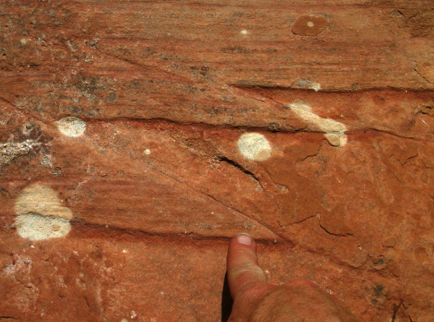
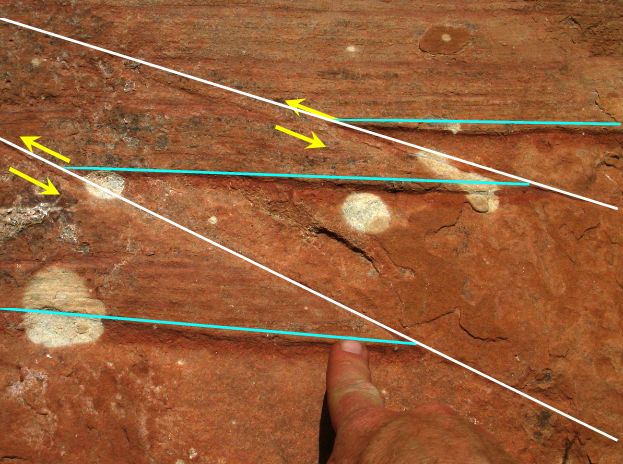
These photos show two small thrust faults, with one bed of sandstone thrust a few inches over another in each fault, and Dr. Alley’s index finger for scale, in a cliff below the Glen Canyon Dam in Arizona. The same principles apply to thrust faults, whether they are tiny or huge —push-together forces shove some rocks over other rocks along a break in the rocks. The rocks were squeezed from left and right, and the yellow arrows show the motion along the faults, which are indicated in white. The turquoise line segments were connected end-to-end as one straight, horizontal line before the rocks moved along the faults.
Virtual Field Trip: Blue Ridge Mountains
To see more on obduction zones, look at the Blue Ridge Mountains VTRIP. It has some pretty pictures, and then a little geologic background. There is another thrust fault, shown by yellow arrows, in the second-to-last picture.
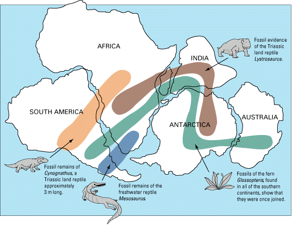
We saw that pull-apart forces occur at spreading ridges. And, if rocks can be pulled apart, they can be pushed together, with push-together forces at subduction zones, or other collision zones. Today, you can look from the Appalachians and from the east coast of South America across the quiet seafloor of the Atlantic, across the spreading center of the mid-Atlantic ridge, to the coastlines of Africa and Europe. The coastlines on either side of the Atlantic are nearly parallel to each other and the mid-Atlantic ridge—slide the new and old worlds back together again, and they fit like a jigsaw puzzle. You can put all the modern continents back together jigsaw puzzle style. This fact, and especially the wonderful fit across the Atlantic, has figured prominently in suggesting the idea of drifting continents to scientists and other observers almost since the first decent maps were available of the Atlantic coasts. More importantly, putting the continent shapes back together in jigsaw-puzzle style puts the “picture”—the geology—back together, as well, for events that happened while the continents were joined. For example, we will see in Module 7 that, if glaciers flow over rocks and then melt, scratches are left that show which way the glacier was flowing. These tracks from a long-gone glacier run out into the Atlantic from Africa, and then out of the Atlantic onto South America. But if you put the continents back together jigsaw-puzzle style, the tracks fit together to show the path of a single glacier from a time when the Atlantic Ocean did not exist. Many other such matches are seen, from the times after the proto-Atlantic Ocean closed and before the modern Atlantic Ocean opened.
The oldest rocks on the Atlantic seafloor are about 150 million years old, approximately the same age as sediments that were deposited in a Death-Valley-type setting in the Newark Basin of New Jersey and elsewhere along the U.S. East Coast. The modern situation of a spreading Atlantic began about then, splitting apart a supercontinent to form the Atlantic Ocean in the same way that Baja California is being split off to open the Gulf of California.
But the Appalachian Mountains are much older than that. A story begins to emerge of a cycle—older push-together forces led to the closing of a proto-Atlantic Ocean that produced the Appalachians. When the proto-Atlantic was closing, subduction-zone volcanoes formed and spread ash layers across the land, much as Crater Lake/Mt. Mazama and Mt. St. Helens did more recently. (Some of those ash layers can be found in many places, including the road cut along the Route 322 expressway just south of East College Avenue in the State College, PA area). Sometimes, the proto-Atlantic subduction zones formed offshore, formed volcanic island arcs, and then their volcanoes moved and collided with the North American continent.
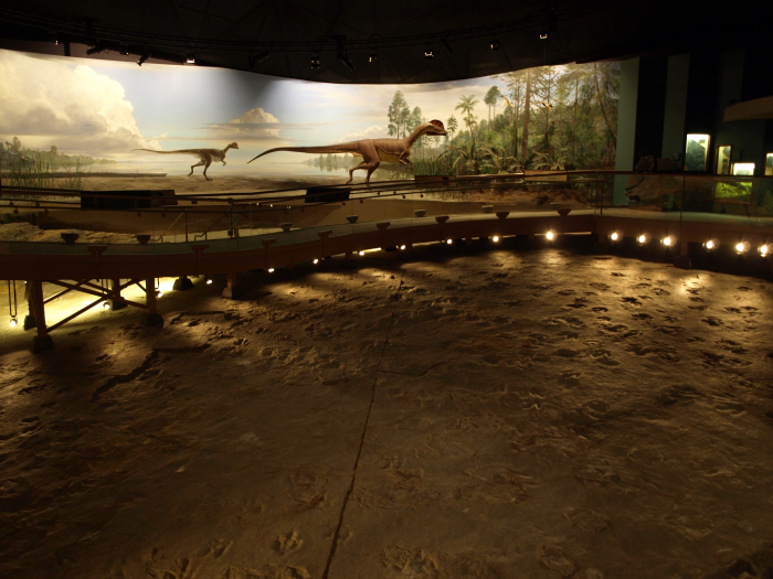
When the pushing stopped, the giant pile of the Appalachians, with deep, hot rocks beneath, began to fall apart in Death Valley style, and red sandstones and mudstones accumulated in Death Valley-style valleys along parts of the U.S. East Coast. Some of these have interesting fossils, such as the dinosaur tracks at Dinosaur State Park in Connecticut; the real tracks are shown in the picture with an artist’s rendition of how the landscape might have appeared. The drop in pressure deep in the earth as the Appalachians fell apart probably caused a convection cell in the deep mantle to rise right there, eventually forming the mid-Atlantic Ridge and the Atlantic Ocean.
Such a cycle, with subduction or continental collisions building mountain ranges that then spread Death-Valley style and eventually split to make ocean basins, has been played out many times over the history of the Earth. And the fun isn’t over yet; North and South America are cruising westward toward Australia and Asia, as the Atlantic widens and the Pacific narrows. Africa is still bumping into Europe and pushing up the Alps, and India has not yet grown weary of ramming Asia to raise the Himalayas. At fingernail-growth speed, the next 100 million years or so should lead to a lot of geological high drama, but the next 100 years won’t see a whole lot of change. The 1:15 minute silent animation below provides a good visualization. (The animation would be more accurate if it made the crust a little thicker in the collision at the end, but otherwise, it is quite good. The animation shows that after the ocean spread for a while, the sea floor near the continent became cold enough and thus dense enough to start a new subduction zone. That might happen on one or both sides of the Atlantic in the future.
Video: Geology: Wilson Cycle (1:15) This video is not narrated.
The key to most of this is that you can sink old, cold sea floor, but you can’t sink a continent. Island arcs and continents float on the mantle too well. So rather than going down the subduction zone with the oceanic lithosphere, an island arc or continent will ride across the subduction zone for a major collision. In such a collision, called obduction, layers of rock are bent into folds such as those near Penn State’s University Park campus, or broken into thrust faults such as those under the Blue Ridge and the Great Smokies. In the case of the Appalachians, the thrust faulting was very efficient, with older rocks sliding tens or hundreds of miles (or kilometers) over younger ones in some places.
To see drifting continents in the past and the future, see the video 240 million years ago to 250 million years in the future.
The Three Structural Styles
The Three Structural Styles
You have now seen, at least briefly, the three structural styles that are possible: pull-apart (Death Valley, spreading ridges); push-together (Crater Lake and Mt. St. Helens subduction, University Park and the Great Smokies obduction); and slide-past (the San Andreas Fault in California). Pull-apart behavior involves stretching of rocks until they break, forming pull-apart or gravity faults (after being pulled apart, gravity pulls one block down past the other). Pull-apart action occurs at the spreading centers, probably where the convection cells deeper in the mantle spread apart. Push-together behavior occurs at subduction and obduction zones, and produces squeeze-together folds and faults, with the faults also known as thrust faults. Slide-past boundaries, also called transform faults, occur where two large blocks of rock move past each other but not toward or away from each other. Slide-past motion produces earthquakes without mountain ranges.
Video: San Andreas Fault (3:16)
Dr. Richard B. Alley: Here's a picture of perhaps the most famous slide-past fault in the world, the San Andreas Fault at the Carrizo Plain in California. We're going to look at these slide-past faults, and we'll also look at what happens when one of them bends. So here's a map of it. And we're going to the Carrizo Plain National Monument, here. Notice the motion of the fault that's indicated. The fault is pretty easy to see if you look at a picture of the Carrizo Plain. There is the fault in yellow. The motion is shown in orange. You can see the motion in the geology. Here, for example, is Wallace Creek, coming in from the right. You might expect it to go straight, the way it once did, but what does it do? It's been deflected by the motion of the fault and it's carried up like that, and then leaks on out the other side. So the fault is moving. It can make earthquakes. People worry about that. But now, let's go back to the map and let's go down to the San Gabriel Mountains National Monument, and the big bend in the San Andreas Fault. So down here the fault is not straight, it's bent, and because of the bend, this motion leads to a pushing together across the San Gabriel Mountains, at the Big Bend. And so we're gonna now see what that does by this next picture, looking across Los Angeles towards the mountains and the National Monument, and there it is, there's Los Angeles. Behind them is the mountains. The push together across the Big Bend has led to stresses that have pushed up the mountains. There are earthquakes associated with this. This is from the 1994 Northridge Earthquake. It was on a thrust fault down in the Basin closer to Los Angeles, but it's related to the squeeze of the big bend. If we go back to our map, imagine for a moment a fault that went the other way. Now what would happen is this, this motion would be carrying this side down, this side up, and you would have pull-apart going on in here. And, in fact, there is a little bit of that going on. Over here there is a pull-apart Basin that has a salty lake in it called the Salton Sea. It is linked to this kind of horizontal motion. This one's from the interaction of a couple of faults, it's a little more complicated, but it is possible to have pull-apart with a bend one way or to have push-together with the bend the other way. And so what do we see? Slide-past faults can make earthquakes, like the San Andreas, but when they bend they may cause push-together that helps to make mountains, or they may cause pull-apart that helps to make basins.
Now, you might imagine that we have oversimplified just a little. There is no law that rocks must move directly toward each other (push-together), exactly parallel to each other (slide-past), or directly away from each other (pull-apart); sometimes you see an oblique motion with rocks approaching on a diagonal. Or the rocks may pull apart on a diagonal. And, a bend in a slide-past boundary may produce pull-apart or push-together features, depending on which way the bend goes relative to the motion, as shown in the video above. A large bend in the San Andreas Fault just north of Los Angeles gives push-together motion, with some impressive mountain ranges and dangerous earthquakes.
Mountain ranges correspond directly to the main boundary types. Fault-block mountains—the Sierra Nevada, the Wasatch Range, the flanks of the great rift valleys of Africa, and the mid-oceanic spreading ridges—form at pull-apart margins. The mountains are high because the rocks beneath them, in the mantle, have expanded vertically because they are the hot upwelling limbs of convection cells. Volcanic-arc mountain ranges form over subducting slabs, where some of the down going material melts and is erupted to form stratovolcanoes; smaller ranges (such as the Coast Ranges of the Pacific Northwest, including Olympic National Park) may form from the sediments scraped off the down going slab just above the trench. Continent-continent or continent/island-arc obduction collisions occur at push-together convergent boundaries as well, producing folded and thrust-faulted mountain ranges.
Why the Great Smokies Are Still So High
Why the Great Smokies Are Still So High
Remember that crustal rocks are the low-density “scum” that floats on the denser mantle. When obduction occurs, this crustal scum is crunched—it goes from long and thin to short and thick, in the same way, that the front end of a car is changed when it runs into a brick wall, or a carpet is changed if you shove the ends together and rumple it in the middle. Then, much like an iceberg floating in the water, a mountain range is a thick block of crust floating in the mantle, with most of the thickness of the mountain range projecting down and only a little bit sticking up.
Notice something else fascinating; when a mountain range is being eroded, the top is taken off, and rocks below bob up almost as high as before. Erosion continues to remove those almost-as-high rocks, allowing more rocks from below to rise. Pretty soon, the rocks at the surface have come from far down in the Earth, where temperatures and pressures are high. And as you might imagine, those rocks were changed by the high temperatures and pressures. The rocks around Penn State’s University Park campus have not been “pressure-cooked” much, but the rocks around Philadelphia have been - they tell the story of a great mountain range that fell apart, leaving the remnant that we know as the Appalachians. The rocks in Rocky Mountain National Park are like those in Philadelphia, in the sense that they once were deep in the Earth and now are at the surface. This is similar to how icebergs work. See the animation below about icebergs to learn more about how isostasy works.
With an iceberg, about 9/10 of the thickness is below the water and 1/10 above. As shown in the narrated diagram below, if you could instantly cut off the 1/10 that is above water, the iceberg would bob up to almost as high as before. A 100-foot-high berg would have 10 feet above the water and 90 feet below. Cut off the top 10 feet, and it is a 90-foot berg with 9 feet, or 1/10, above the water and 81 feet below. So, removing 10 feet from the top shortens the ice above the water by 1 foot and the ice below the water by 9 feet. With mountain ranges, the density contrast between crust and mantle is larger than that between ice and water—only about 6/7 of a mountain range projects down to form the root, and 1/7 projects up to form the range.
Video: Icebergs (3:02)
Dr. Richard B. Alley: Out in the ocean, there's a giant iceberg sitting out here. Big thing threatening the oil platforms floating around. And in the bottom of this very special iceberg, there is a really strange looking, googly-eyed space alien. And you have been given the task to go out there in your little boat sitting here in the water to get the space alien out.
Now, you're a good geoscience 10 student, and you know that all icebergs have about 1/10 above the surface, and they have about 9/10 below the surface. So you know immediately what to do. You take your gimongous chainsaw, and you chainsaw off the top of the iceberg and throw it away, because you know what this will cause is that the iceberg will come bobbing up, carrying the space alien with it.
And so after it gets done bouncing up and down for a little bit, you find that the iceberg is almost as tall as it was before. It still has, sitting way down in the bottom of it, the space alien that you're trying to get to. So there's a space alien down here. And it still has about 1/10 of its height above the surface and about 9/10 of its height below the surface.
But what you find is it's just a little bit shorter than it was, and it doesn't stick down quite as far as it did. Now you wump the top off again, and you keep wumping the top off, and you keep wumping the top off. And after a long time, you get down to a little iceberg that doesn't stick very far down.
Now it still is the same picture, that it has 1/10 above, and it has 9/10 below. And if you're not careful, you're sitting there admiring this lovely fact of science, and the space alien sticks out a giant tentacle, and it grabs your ship and throws it to the bottom of the sea. And so you'd better not do that.
However, there is a scientific piece to this. Suppose, instead of space aliens, that we wanted to talk about mountain ranges. Now, we know that mountain ranges stick up above the plains. But you might not have known that they also stick down.
They have a root in the same way that an iceberg has a root that it's sitting on. There's a slight difference in that about 1/7 of a mountain range is up and about 6/7 of a mountain range is down, way down. The rocks have been heated. They've been squeezed. There are all sorts of interesting things going on and new minerals being grown.
And at the surface, the streams are sitting here, busily trying to grind away the mountain range. As the streams grind away the mountain range, why, the deep stuff will come bobbing up towards the surface. And if you come much later and look at it, you'll find that the rocks have barely any mountains left.
There's still a little bit of root with 1/7 up and 6/7 down. But now what you'll find is that the rocks that had been cooked way down, and bent way down, are very near the surface. And you can go see them.
Still, if rivers or glaciers erode a mountain range (something we’ll study in modules 5, 6, and 7), some of the root is freed to float upward. Only by eroding the equivalent of 7 mountain ranges can you eliminate the mountain range entirely. So, the Appalachians, despite having been deeply eroded, are still high because they still have a root.
The idea that things on the surface of the Earth float in softer, denser material below is called isostasy, which means “equal standing”—each column of rocks on Earth has the same weight or standing. Lower-density columns then must be thicker to weigh as much as thinner, higher-density columns. The continents stand above the oceans because the silica-rich continental crust is lower in density than the silica-poor sea-floor crust. The mountain ranges stand above the plains because the thick, low-density roots of the mountains have displaced some of the high-density mantle that is found beneath the plains, or because the rocks beneath the mountains are especially hot and so low in density. Look back at the animation about icebergs to learn more about how isostasy works.
Put a big weight on a piece of crust (say, an ice sheet, or the Mississippi Delta, or a mountain range) and that piece of crust sinks, pushing up material around it in the same way that the surface of a waterbed sinks beneath your posterior when you sit down, while the surface is pushed up around you by the water that is shoved sideways. The rising and sinking of the land are slower than for a waterbed—thousands of years rather than seconds—because the hot, soft, deep mantle flows a lot slower than water does. But for a mountain range over 100 million years old, a few thousand years doesn’t mean much.
Still More Plate Tectonics: The Rocky Mountains
Still More Plate Tectonics: The Rocky Mountains
Mountain Building and Metamorphism
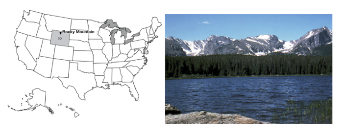
Rising high above Estes Park, Colorado, and almost within shouting distance of the population centers of Boulder and Denver, Rocky Mountain National Park is a natural destination for the crowds that throng to this mountain playground. Long’s Peak, at 14,256 feet (about 4300 m), dominates the south-central part of the park; the peak was first climbed in 1868, by a party that included John Wesley Powell, the man who later commanded the first boat passage of the Grand Canyon and then led the United States Geological Survey. Numerous peaks over 13,000 feet (4000 meters) in Rocky Mountain lure climbers.
Small and rapidly shrinking active glaciers still carve the mountains, and much greater glaciers of the past left the numerous tarn lakes, moraines, and other features that decorate the park. Trail Ridge Road surmounts the high tundra of the park, giving the visitor a first-hand look at periglacial processes and ecosystems (those of cold regions; more on this later). The Colorado River rises on the west slopes of the park, and lovely little trout streams such as the St. Vrain flow down the east slope. Bighorn sheep and elk attract traffic jams in Horseshoe Park.
Virtual Field Trip: Rocky Mountains
Join us as we go on a virtual tour of Rocky Mountain National Park.
Raising the Rockies
Raising the Rockies
It is a tad embarrassing to say that we don’t fully understand the geological history of the Rocky Mountains yet, including the history of Rocky Mountain National Park. The long history of mountain building, erosion, glaciation, etc., is well-known—we can tell the story. But most mountain ranges hug coasts or are formed as coasts disappear in an obduction collision when the ocean closes and obduction occurs, whereas the Front Range of the Rockies is as far as almost 1,000 miles (1600 km) from the coast, yet the Rockies are not the direct result of obduction.
The U.S. West is a complicated region (see the Optional Enrichment section for a little more on this). The continent has been approaching and overriding the East Pacific Rise spreading ridge, which is much like the mid-Atlantic Ridge but is no longer in the middle of an ocean. The San Andreas Fault formed as the East Pacific Rise reached the trench. Before these met, subduction had been occurring beneath the western USA from push-together motion, but with a little slide-past motion thrown in. After the meeting, the subduction stopped, so the push-together stopped, but the slide-past remained to make the San Andreas Fault. To the north of the San Andreas Fault, subduction is still active, forming the Cascades including Mt. Rainier and Mt. St. Helens.
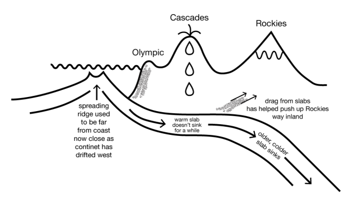
Long ago, the west-coast subduction zone started in the usual way, with the old, cold ocean floor going down into the deep mantle. But as the continent approached the spreading center, the down-going ocean floor became progressively younger, and thus warmer and more buoyant because not as much time had passed for it to cool after its volcanic origin. This warmer ocean floor didn’t “want” to go down, but it was still attached to the older, colder floor ahead of it that was going down. So, the ocean floor that went under the continent stayed high, rather than sinking, and rubbed along the bottom of the crustal rocks rather than plunging steeply into the mantle. The friction between this buoyant subducted ocean floor and the crust above, in turn, caused thrust-faulting and crustal thickening far inland (see the figure below). Because the western part of the country has been built up of many old rock bodies and sediment piles bulldozed from the Pacific, there are scars of many old faults and other geological features that have been reactivated by recent events, so mountains and valleys have formed along the old weaknesses in response to the new pushes.
As to exactly how this came to produce 14,000-foot (4300-m) peaks in the Rockies, geologists can tell the story, but it isn’t clear that any geologist could have predicted this story without seeing the rocks first. Science moves from explaining (easier) to predicting (harder), so we still have some work to do. (And we've oversimplified a bit here; see the Optional Enrichment for more.)
The video below provides additional information in support of the diagram above.
Video: The Rockies (1:57)
Dr. Richard B. Alley: We've been looking at how spreading ridges under the ocean make seafloor, which moves away from them and eventually gets old and cold and sinks down. And it will be sinking down beneath a continent, often, and it will scrape things off to make the Olympic. And then it will have a big volcanic range such as the Cascades, Mount Saint Helen's, and so on.
And they will be sitting there next to the ocean, which we can draw in. And coming up from below, there will be melt to make seafloor out here. And coming up from below there will be materials that erupt at the volcanoes like that.
Now, that works all fine, but what happens when there is a little bit of a swinging down of the slab? We know that the slab is moving away from the seafloor spreading ridge, as I show here. But the slab really does have a little of this swinging down, as well, in some cases. And the continent moves to catch up with it.
And so pretty soon, the continent is going to end up getting close to the spreading ridge. And the stuff going down is then not going to be cold. It's going to be getting warmer.
And when that happens, we have to erase this, because now the materials don't want to go down anymore. You'll get something that goes more like this, with it running right underneath the edge of the continent and staying high. And where it runs under the continent and stays high, you'll get a lot of rumpling, a lot of pushing happening in this way. And so then you might expect to see something that gets pushed up like this. And we're reasonably confident that that sort of push-up is what the Rockies are.
In a few cases, as in the west, where the San Andreas Fault is, in fact, the subduction zone has been pushed all the way out and has run over the spreading ridge. And, the subduction zone and the spreading ridge annihilated each other. And then you've got the San Andreas Fault.
The Rockies, like the Smokies, were formed by push-together stresses, and the high peaks float on a thick root. Erosion of the peaks has allowed the root to bob upward, so the rocks revealed at the surface include types that formed far down in the Earth and then were brought to the surface. This includes rocks such as granite that solidified from melted rock far below, and the changed—metamorphic—rocks we will discuss below. The bobbing up of the mountains tends to drag surrounding rocks upward. If you drive toward the Rocky Mountains in Colorado from the plains to the east, you can see these dragged-up rocks adjacent to the high peaks. See the narrated diagram for more background.
Video: Red Rocks (2:36)
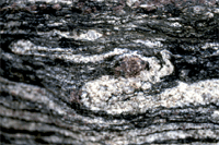
Dr. Richard B. Alley: We're going to learn some things about metamorphic rocks now. But we're going to start with my finger shoved up through a piece of paper. And when I shoved the finger up, it dragged the paper up along that curve you see indicated by the red arrow. We've been talking about mountain ranges formed by squeezing together, that gives you high peaks, floating on a thick root. And how once you get those peaks up there, erosion tends to take them off. But then the root comes bobbing back up to make the peaks almost as high as they were. You might think that if you had some layers of rock nearby that they would be dragged up along the rising mountains, and in fact they are. And you can see this in many places. One of the really good places to see it is along the front of the Rockies. So this is just outside of Denver, at a place called Red Rocks. The mountains are just off to the left of this picture, and they bobbed up like that. And you can see these dragged-up rocks that are so spectacular along there. You find this all along the front of the Rockies. This is down at Garden of the Gods near Colorado Springs. The dragged-up rocks are in the foreground and in the back is Pike's Peak. Pike's Peak here is granite that solidified way down in the earth, and it is surrounded in many places by metamorphic rocks. Now metamorphic rocks most commonly start out as mud, as a mud rock that's called shale. And if this is buried way deep in the earth, it is heated, it is squeezed, it gets chemically active fluids, it changes. By the way, that is the toe of my running shoe for scale, so you know how big it is. And when it changes, you may end up with either melted rock altogether, you get granites, or you can end up with metamorphic rocks. And here are some metamorphic rocks at the bottom of the Grand Canyon. You find things like this in the Smokies, the Rockies, and elsewhere. So it really is true - the mountains get high by being squeezed horizontally. They have deep roots. Erosion takes off the top. The bottom comes up. Sometimes you see where the next-door rocks were dragged up, and eventually, in the heart of the mountain range, you see something that once was very, very deep.
Cooking the Earth
Think about cooking. If you mix up a bunch of ingredients to make a cake batter, throw the mixture into a pan, and put it into a warm oven, the cake you obtain will not be very similar to the mixture you started with. Grill a steak or a meat substitute, and the original cow part or vegetable-based material will come out quite different. Marinate the steak or meat substitute before grilling, and more differences appear. It is common knowledge that a material that is stable in one environment will change if it is placed in a different environment. This is true of everything (and everyone!) on Earth.
The Earth has a great range of conditions. The inside of a mountain range is hotter, has higher pressure, and is less affected by acidic groundwaters than the surface. Materials that are stable at the Earth’s surface (such as the clays in a piece of shale) are not stable deep in a mountain range. The minerals change, grow, and produce new types even without melting. This process is called metamorphism. Metamorphism makes rocks that many people consider to be especially pretty (see the video on “Toothpaste Rocks” from the Grand Canyon), produces some wonderful gems, and contributes rock names that make good puns. (The Geoclub at Wisconsin liked puns and used a metamorphic rock, a volcanic rock, and a sedimentary rock in claiming that geologists are “gneiss, tuff, and a little wacke.”) You can read a little more about rocks and minerals in the Enrichment section.
Toothpaste Rocks: Grand Canyon National Park
Metamorphic rocks—those cooked and squeezed deep inside a mountain range—are often especially pretty. At the bottom of the Grand Canyon, you can see such rocks. They were formed long ago, and many miles down, and then reached the surface as erosion removed the mountains above and the deep roots of those mountains floated upward. Later, these rocks were buried again under sediments from oceans, rivers, and wind, and finally revealed to us as the Grand Canyon was carved by the Colorado River. Some people—including Dr. Alley—think that these rocks are so beautiful that they're worth the overnight hike into the canyon all by themselves!
Video: Toothpaste Rocks - Grand Canyon National Park (2:22)
[MUSIC PLAYING]
Dr. Richard B. Alley: This is the most glorious place. Just look at this place. We're sitting on these old rocks, these seriously old, 1.7 billion-year-old rocks.
Everything around us that's black didn't quite melt. Everything around us that's pink actually did. That was molten magma squirting into cracks. And the stuff that didn't melt was like toothpaste. It was so soft, because it was so hot, that it just flowed and crinkled and folded, and--
It's been bent, and one can follow any of these layers along. And you see that they wiggle, and they come around, and then they come out here and back. And so these rocks were really, really hot. They were almost up at the melting point.
And they were being squeezed. There was mountain building of some sort going on that caused them to have squeezing and to be pushed from here to there. And as they go, very often, you get something like this folding. If you take a phone book and squeeze it, it'll fold. And in the same way, when you squeeze these rocks, you end up folding them.
The other part that's interesting, here, is that we can see these beautiful things so very well because this stream has come over them. And it's eroded them, and it's polished them. And the surface that we're on is very smooth.
But this is the heart of the mountain. This is what it would look like if you could get down in a mountain range somewhere, down there about 5 or 10 miles. And that's what we're standing on.
Migmatite. M-I-G-M-A-T-I-T-E. It's not quite magma. It's migma. Mixed magma. And you'll see all of these awesome morphs and wiggles and the little things through here.
This melted. This didn't. This melted. This didn't.
Oh, this layer-- that's beautiful. These things have been really, really hot.
Where Tectonics Meet People: Tsunamis
Where Tectonics Meet People: Tsunamis
Tsunamis
We have been looking at the ways that rocks move around on Earth and make mountains and some of the ways that this mountain building can threaten humans. Volcanoes and earthquakes are sometimes truly dangerous and damaging. But it is worth remembering that, in the developed world, only a few percent of us die in “accidents,” and car crashes greatly dominate those deaths (so the great majority of us die of other things, such as heart disease, cancer, etc.). With good scientific warnings, good zoning codes, trained medical personnel, hospitals, and ambulances to take care of us, nature kills very few of us (something like 0.03% of deaths in the US in most years). (In the less-developed world, this is, sadly, less true.) For the developed world, things we do to ourselves (smoking, eating, drinking too much, not exercising enough) are far, far more destructive to health and life than anything the planet does to us.
But it is still wise to know about the dangers from the Earth—part of the reason so few of us die from natural disasters is that we are already doing wise things to avoid being killed by nature! Some of those wise things involve preparing for giant waves—tsunamis (and preparing for earthquakes, landslides, volcanoes, floods...). Tsunamis are not directly related to our National Parks in this module, but tsunamis are related to some of the processes that helped make the Great Smokies and the Rockies. Anything that makes earthquakes, volcanoes, or steep slopes in or near the sea might be involved in a tsunami. And tsunamis can be truly horrific. We’ll start discussing a long-ago tsunami from a hot-spot setting and then look at other tsunamis closer to us.
Anomalous deposits are found on the flanks of many of the Hawaiian Islands, including Lanai, Molokai, and Maui, to at least 1,600 feet (500 m) above sea level. These deposits are composed of broken-up, mixed-up, battered corals, other shells, and beach rocks. Corals are undersea creatures and surely don’t grow 1,600 feet above sea level. It is true that some corals grow just below sea level and later are raised above the water by mountain-building processes; however, these Hawaiian deposits occur on islands that are sinking as they slide off the “hill” made by the Hawaiian hot spot, and the deposits are geologically too young to have been raised so far by mountain-building processes. Clearly, something strange happened.
One of the deposits, in particular, is the same age as a nearby, giant underwater landslide, as nearly as the age can be measured. The Hawaiian volcanoes have rather gradual slopes above the water, where the hot, low-silica lavas spread out to make shield volcanoes. But when lava hits the water, the hot flow cools and freezes very quickly, and can make steep piles. When a slope is too steep, it can fail in a great landslide, perhaps when melted rock is moving up in the center of the island and shoving the sides out to make them steeper. Surveys by specially equipped research vessels using side-scanning sonar have shown where several such slides have slipped. Such landslides can be miles thick, tens of miles wide, and over 100 miles long.
If a chunk of rock miles thick and tens of miles wide suddenly starts moving, maybe at hundreds of miles per hour, it will shove a LOT of water out of the way. Where will the water go? The answer is that it will make a huge wave, or tsunami, that will race across the ocean, and up onto any land it encounters. Imagine a wave so huge that it would run far inland and reach heights of 1,600 feet above sea level. Fortunately, the highest deposits in Hawaii are from a tsunami about 110,000 years ago, long before people were living there. Although many such tsunami-generating landslides have occurred, they typically are spaced thousands of years apart or more. But we can’t guarantee that there won’t be another one. See the animation below for a worst-case scenario.
Video: Tsunami visualization (2:05)
Virtual Eye Narrator: The entire mountain swells, which means that the outer slopes get steeper. There are probably a succession of small earthquakes; and then maybe a big earthquake that shakes loose this very steep western flank of the volcano. Almost 1500 cubic kilometers of Earth and rock plummet into the sea. On impact, the land displaces a massive amount of water. The ocean rushes back to fill the giant gap. From this cataclysmic disturbance emerges the tsunami, heading directly for Honolulu. Estimated time to impact, 30 minutes. This is the direction that a big tsunami would come from, the Big Island. The wave first becomes visible as it stands and breaks on a shallow bank 40 km southeast of Honolulu. You'd see the sea rear up in front of you. It would be huge. It would rise up above you the size of a building, the size of a 10-story building. Surging Inland at up to 70 km per hour, the tsunami slams Honolulu. Because the tsunami's energy stretches down the ocean floor, this wave is not clean water, it's filled with sand coral, and rock. Water penetrates 16 km Inland before being sucked back out to sea in a lethal maelstrom of wreckage. It annihilates nearly everyone and everything in its path.
The word tsunami comes from two Japanese words, for harbor and wave, a sort of shorthand for a wave that devastates a harbor. Most tsunamis are generated by undersea earthquakes, but undersea landslides, volcanic eruptions, and even meteorite impacts in the water can generate tsunamis.
Tsunamis move rapidly across the deep ocean, with speeds of 300 to 500 miles per hour (480 to 800 kilometers per hour). In the deep ocean, the “bump” of water that is the wave of a big tsunami may be only a very few feet high but may extend well over 100 miles in the direction it is moving. Waves slow down as they enter shallower water, and the leading edge of a wave hits shallow water before the trailing edge. So, the leading edge slows as it nears the coast, the trailing edge that is still in deep water catches up, and the wave goes from being long and low to being squashed and high. Even so, the tsunami wave is usually not a towering wall of water, but a strong surge, something like the tide coming in but higher (hence the mistaken name “tidal wave”).
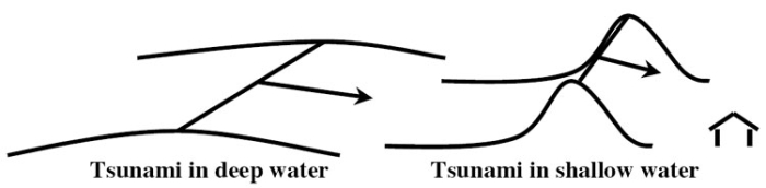
An especially nasty feature of a tsunami is that the water often goes out before it comes in. (Waves consist of troughs and crests, and while the crest arrives first in some places, the trough arrives first in other places.) The sudden retreat of water and exposure of the sea floor tempts people to walk out and look around. Then, the ocean returns faster than a person can run. The outcome is very unpleasant.
Video: NOAA Tsunami Animation (1:27) This video is not narrated.
Terrible tsunamis have occurred. The greatest loss of human life from a tsunami was probably the Indian Ocean tsunami of 2004, which was triggered by the second-largest earthquake ever recorded, and killed roughly 230,000 people. Second was the tsunami from the 1755 earthquake near Lisbon, Portugal that killed about 60,000 people, especially in Morocco, Portugal, and Spain. The massive 1883 explosion of the volcano Krakatau in Indonesia essentially destroyed the island, with tsunami waves observed as far away as England. Floods raced miles inland on Java and Sumatra, killing approximately 40,000 people. The volcanic eruption of the Greek island volcano Santorini in the 1600s BCE pushed a tsunami perhaps 300 feet (100 m) or higher across the coast of Crete and may have contributed to the eventual demise of the Minoan civilization there. Many commentators have suggested that this is the source of the myth of Atlantis. The great 1964 Alaska earthquake generated a deadly tsunami that killed 118 people, with deaths as far away as California. In 1958, an earthquake-caused landslide in Lituya Bay, Alaska, caused a tsunami that included a wave 50-100 feet high in the bay, which a father and son safely rode out in a boat. They watched in awe as the wave then ran 1,800 feet up an adjacent coast; five people were killed in the event. Many other destructive tsunamis have occurred.
There isn’t a whole lot that can be done to stop tsunamis, but the loss of life and property damage can be limited. Tsunami warning systems are functioning in many places and are being extended rapidly. When instruments (called seismometers) sense the shaking of the Earth from a large undersea earthquake, volcano, or other disturbance, the signals are analyzed rapidly to see if characteristics suggest that a tsunami is likely, and if so, communications are sent out to various agencies concerned with safety, and sirens or other warnings on beaches are activated to get people away from the coast before the tsunami arrives.
The Indian Ocean tsunami of 2004 seems to have been especially deadly in places where human activities had caused damage to the coral reefs and coastal vegetation that would have blunted the strength of the wave, so maintenance of such natural buffers along these and other coasts can help protect the people living nearby from any future tsunamis. Scientists can figure out where tsunamis are likely, how big and how frequent they are likely to be, and then zoning codes can be enforced so that people build in safe ways on safe land if they want to live in an area.
Virtual Field Trip: Tsunamis
Please join us on a virtual field trip of Tsunamis.
Optional: Want to see more?
Tsunami Visualizations
(An extensive collection of animations on this subject)
Mountain Uplift and Erosion
(An extensive collection of animations on this subject)
Optional Enrichment Article
Optional Enrichment Article
Raising the Rockies
As noted in the text, the geologic history of the US West is quite complex, with some big questions not yet answered, and more work to be done. The most widely accepted history, with the most scientific support, is sketched in the text and given in a bit more detail just below and in the Optional Rock Video Review, The Hanging Wall.
Much evidence indicates that before about 100 million years ago, the down-going rocks in the subduction zone in the west went down steeply, but after that time the rocks' angle reduced (so, the rocks continued to move horizontally, but with less downward motion). The Pacific seafloor that was sinking under what is now Seattle is called the Farallon Plate, and rather than going down somewhat smoothly into the deeper mantle, the Farallon began to move along just beneath the lithosphere of the North American plate. The text notes that the plate was slowly getting warmer over time and thus more buoyant because the ridge and trench were getting closer together, so the plate was having less and less time to cool off before it went down the subduction zone. Another reason, and perhaps a more important reason, may be that a huge volcanic outpouring on the sea floor more than 100 million years ago made a thick layer of not-very-dense rock, which began going down the subduction zone about 100 million years ago. Where smaller bumps on the sea floor are going down subduction zones today, as off Costa Rica, features like those seen in the US West are forming, so the bigger features of the West are easy to explain this way.
Anyway, friction between the top of this buoyant Farallon Plate and the rocks above it—the rocks that we see in the Rocky Mountains and elsewhere in the US West—began to squeeze, bend, and break those rocks above. The breaks are thrust faults, with older rocks thrust upward and over younger rocks to make the mountains. You will recall that the rocks above the fault are the “hanging wall”, which gives rise to the pun in the Rock Video.
Where a fault didn’t break all the way to the surface, it often raised the rocks above (think of lying on your back in bed under covers and then raising your knees—the cover draping over your knees represents the unbroken rocks). If the rocks were raised in a more-or-less circular pattern when viewed from above, we call the feature a dome; if shaped more like a US football when viewed from above, it may be called an arch, and a few other names are sometimes used. Such uplifts gave us the Black Hills of South Dakota (with Wind Cave National Park), the Waterpocket Fold of Capitol Reef National Park, the Kaibab Uplift that the Grand Canyon cuts through, the beautiful San Rafael Swell of central Utah, and many other features of the West. These events mostly happened soon after 100 million years ago, during what we now call the Sevier Orogeny, and somewhat more recently in the Laramide Orogeny—we see more faults from the Sevier and more uplifts from the Laramide.
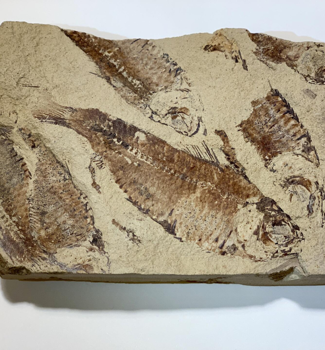
The squeezing and thrusting of mountains caused some layers to bend down while other layers bent up. One of the low places this caused held the lake in which the pink limestones were deposited that we now see at Bryce Canyon National Park and Cedar Breaks National Monument, and similar lakes gave us the Green River limestones that produce such fantastic fish fossils from farther north in Utah. Oil is found in the west in some of the rocks that were bent down, too.
The Farallon Plate probably eventually broke, and a new, “normal” subduction zone started up, feeding Mt. St. Helens and Mt. Rainier in the west. The Farallon Slab is now sinking beneath the eastern part of the US. As it sinks, it creates space into which hot rock flows slowly, and this may be helping “rejuvenate” the Appalachians, so the Great Smokies and other parts of the Appalachians are a bit higher than they would be otherwise because of processes traceable back to the Rockies and the Farallon. Why the Farallon “decided” to sink eventually may be because, as it ran into thick rocks beneath the west, either some of the low-density parts were peeled off so the higher-density ones could sink, or the low-density ones were shoved deep enough that the pressure changed the mineral structures, making denser minerals that can sink.
Anyway, there is still much to discover about the western US. But, to catch a light-hearted version of what we know, check out the tale of a geology student trying not to be hung on the Hanging Wall.
Video: Hangin' Wall (4:29)
[MUSIC PLAYING] PROFESSOR RICHARD ALLEY: (SINGING) I came out from the Eastlands, and so no one made a slip. I showed 'em my intentions with a Brunton on my hip. I came out to where the mountains, cliffs, and mesas tower tall, to read the planet's story written on the hanging wall, on the hanging wall.
[MUSIC PLAYING]
I was hungry, young, and foolish when I started on my quest. But with a hammer, and a field book, and a map that pointed west, I left behind the ridges that the rivers rounded small to learn the truth or perish here hung from the hanging wall, from the hanging wall.
100 million years ago beneath Pacific brine, the Farallon was sinking down subducting smooth and fine 'til the slab of thickened sea floor tried to squeeze through spaces small. And the squeeze is on the westlands that would make the hanging wall, make the hanging wall. Severe Sevier orogeny, a thin-skinned thrusting belt, as the friction of the buoyant, thickened ocean plate was felt. It broke the rocks and thrust from westward raising mountains tall. Older rocks thrust over young to make the hanging wall, make the hanging wall.
[MUSIC PLAYING]
As the thickened crust moved eastward and then turned to sink anew, the Laramide Orogeny raised domes and arches too. The Black Hills, Water Pocket, and the Kaibab as well, Wind Rivers and Uintas and the great San Rafael Swell, great San Rafael Swell.
From mountains rising in the west, a heavy load was shed, and now basal conglomerate records that river bed. But fining up and liming up soon gave us what it takes to wash the West's interior, Bryce and Green River Lakes, Bryce, Green River Lakes. But the spreading ridge, it hit the trench to make a slab window, a growing space that filled in with a hot, upwelling flow. The squeeze relaxed, the mountains spread, and though it may seem strange, new hanging walls dropped downward, normal faults, basin and range, normal faults, basin, and range.
Volcanoes leaked up some new faults, but in other outcrops clear. In the footwalls of young normal faults, old thrust faults now appear. I can read the mighty story and it leaves me feeling small. I lift the map another day safe from the hanging wall, from the hanging wall.
I'm older now and wiser as I head back from my trek. But I won't die with a hempen rope around a stretched-out neck. There's still more to learn tomorrow as it holds me in it's thrall. I'll be back to read what else is written on hanging wall, on the hanging wall. Hanging wall, hanging wall, I'll be back to read what else is written on the hanging wall.
Still more about plate tectonics and related topics
What happens when you "cook" a rock metamorphically depends on how hot it becomes, and what chemically active fluids are present, and the pressure and deviatoric stress. Both pressure and stress have units of force per area and represent a "push" on a material. Pressure is the part of the stress that is the same in all directions--it squeezes rocks or fluids to make them smaller but doesn't tend to change their shape. Deviatoric stress, sometimes just referred to as stress, is an extra push or pull in one or more directions, and does change the shape. Deviatoric stress has been involved in aligning the mineral grains of most metamorphic rocks into layers, or folia. Chemically active fluids—water, carbon dioxide, methane, etc.—can add or subtract chemicals, lower melting points, and dissolve and reprecipitate chemicals.
Materials that are stressed deviatorically can have one of three responses. The materials may bend and, when you release the stress, snap back (elastic deformation), they may bend permanently (plastic deformation or creep), or may break. We have already seen examples of all of these. Earthquakes are caused by the snap-back of rocks near faults following bending. Faults such as the San Andreas are the result of breakage, and folds such as those around University Park, or those in the rocks exposed in the heart of the Rocky Mountains, are the result of plastic deformation.
Whether a rock bends elastically or plastically or breaks, depends on the rock itself and on several other factors: heat (or more properly, how close a material is to melting), pressure, deviatoric stress, and even the chemically active fluids, acting over time. Elastic deformation is favored by low stresses, high pressures (to prevent breakage), and low temperatures (to prevent creep). Plastic deformation is favored by low stresses, high pressures (to prevent breakage), and high temperatures (to allow creep). Fracture is favored by high stresses and low pressures (to allow breakage), together with low temperatures (to prevent creep). Pressure matters in breakage because, to break a material, the two sides must be pulled apart, which increases the size of the material. When pressure is high, this is difficult to achieve. Fluids generally soften rocks and promote creep, although the details depend on the fluid and the rock involved. (“Fracking” to recover oil and gas from rock involves first pumping high-pressure fluids into holes to fracture the rocks, so while fluids generally soften rocks to promote creep, they don’t always do so). You will often see that the rocks in a region will have undergone both permanent folding and breakage, and may be bent and ready to snap back, with different modes of deformation more important in different places. Figuring this all out is fascinating, as well as useful (miners, well-drillers, and many others want to know what they'll hit in the rocks, whether the rocks are about to break, what kind of cracks the oil or gas or ores may be hiding in, and much more).
Melting and Freezing with Chemistry
If you take water and freeze it, you obtain ice that is made of the same stuff as the water. Melt the ice, and you have the water back. Melting and freezing without separating chemicals is easy to understand but is more an exception than the rule. If you take beer and start to freeze it slowly, the crystals that form will be almost pure water ice, although each crystal typically will start to grow on a small impurity particle in the beer. Filter the crystals out, and you will have cleaned the remaining beer a little, and you will have increased its alcohol content. Hire some advertising agents, and you have a “new” product to pitch: ice beer. (If you're underage, please substitute iced root beer. Freeze that, and you'll end up with a lot of ice and a little sugar water.)
In the world of rocks, things are even more complex than with (root) beer. Suppose you take a piece of granite (containing quartz, mica, potassium feldspar, and a sodium-rich sodium-calcium feldspar) and melt it by heating it hot enough to melt basalt. Suppose you then start to cool it. The first minerals to crystallize may be a little bit of olivine, and a calcium-rich sodium-calcium feldspar, minerals that were not in the original granite at all. Cool the melt a little more, and the olivine and remaining melt react to make pyroxene, while the feldspar and melt react to make more feldspar that is richer in sodium. Keep cooling, and eventually, you will grow crystals of the original sodium-rich feldspar and the mica, followed by the potassium feldspar and the quartz, regaining the original granite.
This ideal sequence may not be observed in many situations, but portions of it are well-known in laboratory experiments and in nature. In general, the first things to crystallize are poorer in silica, sodium, potassium, and aluminum, and richer in iron, magnesium, and calcium than the melt from which they grew. As the temperature drops, the early minerals react with the melt to make new minerals that are more like the original melt in composition. However, if the early minerals are removed from the melt, perhaps by settling to the bottom, they may be preserved, and exceptionally silica-rich rocks will be formed from the minerals that grow from the remaining melt. For more on the minerals, look at our "Sidebar" next.
Sidebar: Minerals and Rocks
If you throw a bunch of typical Earth chemicals into a pot, melt them, and cool them slowly, you will find that only certain things grow. You might, for example, find the mineral quartz (SiO2), the mineral pyroxene (FeSiO3), or the mineral olivine (Fe2SiO4). You will not find something midway between olivine and pyroxene; it doesn’t exist. Nature puts the chemicals together in certain ways, and only in certain ways. It is a little bit like building with Tinkertoys or Legos—there are only certain ways you can put the pieces together, which limits the things you can build.
Minerals are orderly—the same basic structure is repeated over and over and over (say, a silicon surrounded by four oxygens, each oxygen in contact with an iron that then contacts another oxygen that is one of four around another silicon, which is the structure of olivine). When minerals are allowed to grow freely, they assume certain shapes that look as if a gemstone cutter had shaped them. The faces on such crystals are controlled by the underlying order of the chemicals. The classification of minerals is based on their chemical composition. (Some chemical compositions can be put together in only a single mineral structure, but other chemical compositions can be put together in two or more different ways, each of which is a different mineral.)
Rocks are collections of minerals. You can find an all-olivine rock, or an all-pyroxene rock, a mostly-olivine/some-pyroxene rock, or any other possible combination. We, humans, have chosen to classify rocks based first on their origin, and then on other characteristics such as their grain size, their composition, or more details of their origin. The main subdivisions are igneous (rocks that formed from the cooling of melted rock, magma, or lava on the Earth's surface), sedimentary (rocks formed from pieces of pre-existing rocks, or from such pieces that dissolved in water and then crystallized from the water), and metamorphic (those formed from igneous, sedimentary, or older metamorphic rocks by the action of heat, pressure, stress, and chemically active fluids).
The classification of igneous rocks is next (we'll do igneous and then metamorphic and save the classification of sedimentary rocks for later in the semester). We distinguish coarse-grained rocks that cooled slowly from magma deep in the Earth, and fine-grained rocks that cooled rapidly from lava at the surface; the extreme case is obsidian, a glass that cooled too rapidly to allow crystals to grow. And, we distinguish rocks based on how much silica they contain. Low-silica rocks most commonly contain the minerals olivine, pyroxene, and calcium-aluminum-rich feldspars. High-silica types include quartz, potassium- and sodium-rich/aluminum-poor feldspars, and mica. Putting these together (grain size and composition) allows us to draw the following grid:
| Grain Size | Low Silica | Medium Silica | High Silica |
|---|---|---|---|
| Small Grains | Basalt | Andesite | Rhyolite |
| Large Grains | Gabbro | Diorite | Granite |
Of these, basalt dominates the sea floors, andesite dominates island arcs, and granite to diorite are common in the hearts of mountain ranges. Many other types occur, but these are the most important ones.
Side Bar: Metamorphic Rock Classification
The most common sedimentary rock is shale or mud rock, and the most common metamorphic rocks are formed from sedimentary rocks. For our purposes, then, we will just list the metamorphic rocks that are formed from shale. With increasing heat (or time), the crystals get bigger, and some new minerals are formed. The general trend is shale (essentially mud rock), slate (harder, clinks rather than thuds when you rap it, but with grains too small to see), schist (lots of micas, grains visible to the naked eye), and gneiss (minerals have separated into dark and light layers). All of these are foliated—they appear layered. The foliations in shale come from the sedimentation of small clay flakes. Those in slate, schist, and gneiss come from the alignment of mica grains that grow in the rock, in a direction controlled by the squeeze in the mountain range. Contact metamorphic rocks—those that form by being "cooked" where magma is forced into colder, preexisting rocks to form granite bodies or other igneous intrusions—don’t have the squeeze of mountain ranges and so aren’t foliated. But contact metamorphic rocks are heated, and often made wet by water that comes from the magma or by surface water that is driven to convect through spaces in the rocks by the heat of the magma. The most common mineral in many contact-metamorphic rock is amphibole, a water-bearing silicate with four silicons to eleven oxygens. The most common rock of this sort contains a lot of amphiboles and is called amphibolite.
So Why Did North America Run Over the Spreading Ridge in the Pacific?
Good question. We’re not sure. But we do know that mid-ocean ridges are high because they are hot. Plates will slide off high spots, heading toward low places. So, North and South America are being pushed westward because they are sliding off the mid-Atlantic spreading ridge. If the spreading center in the Pacific simply sat still for a long while (which it probably did, more-or-less), then eventually the Americas would get to it, which they seem to be doing now.
A Rocking Review
A Rocking Review
Peaceful Easy Obduction
The Eagles rock music group sang about the peaceful, easy feeling they got while going into the desert, but they didn’t tell us whether they planned to do a lot of geology on the way. Whatever; in this parody, you can get a peaceful, easy feeling about a whole mountain range, the beautiful Appalachians. The proto-Atlantic Ocean did close before re-opening as the modern Atlantic Ocean, acting like a very slow accordion. While the proto-Atlantic was closing, three "collisions" happened, raising mountains near the modern east coast of the US, and erosion of the mountains produced sand that now is the sandstone of the ridges of central Pennsylvania and other places along the Appalachians. The first two collisions—small obduction events—involved North America hitting island arcs containing explosive volcanoes formed at former subduction zones. The third collision was the major obduction event as the proto-Atlantic disappeared, with Africa and Europe meeting the Americas as the great supercontinent of Pangaea was assembled.
Geologists long ago decided that the place where subduction occurs is a "subduction zone” but have been slow to adopt an "obduction zone" for the place where obduction occurs. We just couldn't make the rhyme scheme work in our parody with "the mountain range formed where an obduction event happened", so we call it an obduction zone. No one is quite sure whether the mountains in our "obduction zone" were as high as the Himalayas, or how many glaciers eroded the top of our obduction zone, but the mountains probably were quite high (more or less the height of the Andes today) and at least some of the early Appalachians may have been glaciated. The diagrams in this rock video have been simplified a bit, to make it easier for you.
So, relax, get out your Irish flute, and let's go obducting.
Video: Peaceful Easy Obduction (5:02)
[MUSIC PLAYING] DR. RICHARD ALLEY: (SINGING) I like the way your folded mountains lay, waving smoothly across the land. I want to hike across your thrust faults today, with your ancient rocks on either hand. I get a peaceful, easy feeling, where so much history is shown, while I'm living and I'm loving in your old obduction zone.
Proto-Atlantic slowly closed long ago, Old World drawing near the New. Subduction zones fed many a volcano, island arcs eruptions blew. See their ashes in your roadcuts, while small collisions sent down sand. And the mighty obduction was drawing close at hand.
I found out a long time ago, continents cannot sink down. But in collisions, they will fold and break. So they make deep roots and a mountain crown. Your roots were heated, metamorphic, while glaciers carved the peaks you'd grown. The Himalaya became the Smokies of your old obduction zone.
Then as the rivers washed the heights away, rocks down deep bobbed up to light. So I can feel them on your ridges today, and hold them in your valleys tonight, because I get a peaceful, easy feeling, so many secrets ours alone, while I'm living and I'm loving in your old obduction zone.
[MUSIC PLAYING]
Module 4 Wrap-Up
Module 4 Wrap-Up
Review Module Requirements
You have reached the end of Module 4! Double-check the list of requirements on the Welcome to Module 4 page and the Course Calendar to be sure you have completed all the activities required for this module.
Comments or Questions?
If you have any questions, send an email via Canvas, to ALL the Teachers and TAs. To do this, add each teacher individually in the “To” line of your email. By adding all the teachers, the TAs will be included. Failure to email ALL the teachers may result in a delayed or missed response. For detailed directions on how to do this, see How to send an email in GEOSC 10 in the Important Information module.