Module 9: Deep Time: Stratigraphy and the Sedimentary Record
Welcome to Module 9
Welcome to Module 9
Deep Time: Stratigraphy and the Sedimentary Record
With apologies to the great detective Sherlock Holmes, here is a brief introduction to the science of geological history and multiple working hypotheses, together with some bad Sherlock Holmes jokes. If you don’t know anything about Sherlock Holmes, just note that scientists and detectives can learn what caused events in the past. One way we do this is through “multiple working hypotheses”. After you observe something, you generate as many hypotheses as you can about what produced the thing you observed, figure out what each of the hypotheses predicts about additional things you could observe, and make those observations to see which of your hypotheses comes closest to being correct.
"Holmes, did you realize that this chess board is exactly 12 inches long?" I asked, as we sat across the table in our Baker Street lodgings.
"Come, Watson. The game is a foot," he replied. "We must explain the Giant Splat of Sue Matra's birthday."
"The Giant Splat? Holmes, I know that Sue Matra is a friend of your brother Mycroft, but how came she to have a giant splat on her birthday?"
"Sue returned home from her job as a scientist measuring the air speed of swallows carrying coconuts and discovered a splat on the floor. Here is a brief diagram of the situation."
Holmes rapidly sketched the following:
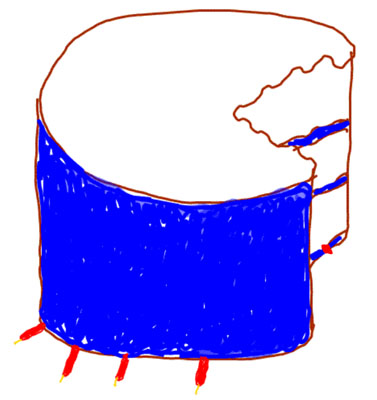
"This takes the cake," I commented sweetly, after studying the diagram.
"No," he replied, "The cake was left on Sue's floor."
"Holmes," I said, "You know that my medical training exposed me to the scientific method and that in my military experience, I conducted forensic investigations, learning what people died of. I was even exposed to geology and paleontology during my studies at the college. Your science of detection shares much with forensic medicine, and with the fields of geology and paleontology. Something has happened, and you try to determine what."
"Indeed, Watson, I am aware that you are among those few individuals who have been trained to reason from effects to causes, so unusual in a world full of people who reason only from causes to effects."
"But it is more than that, Holmes. When faced with an effect, we quickly try to think of all possible causes that are consistent with the available data and with our other knowledge about the world—call these 'multiple working hypotheses'. Then, we see what each of them predicts that we might discover or measure—each possible hypothesis is a possible cause, and we reason to its effects in the same way that other people reason from causes to effects. But we go further, and we make those measurements or observations that will identify the effects of each of our likely causes, using the results to eliminate some of the hypotheses. For example, if we postulate that a horse stomped on the cake to make the giant splat, then we expect the mark of a horseshoe in the cake."
"Even if the horse missed, the shaking of the ground might have caused the cake to fall. Close counts in horseshoes and hand grenades, as you know."
I ignored his attempted witticism, and said, "Holmes, allow me to send a few telegrams to test some hypotheses, and we will soon have the answers."
An hour later, I was ready to explain the giant splat to Holmes. "Sue Matra is married to a diligent and helpful husband, who is also an amateur cook. He confirms that he was baking a birthday cake for Sue, and made it in three layers, putting down a layer of cake, then icing, cake, icing, cake, icing. Then, he put candles in, and carefully carried the cake across the study toward a table. Unfortunately, the couple owns a large and boisterous retrieving dog, which jumped up and took a large bite out of the cake."
"The curious incident of the dog in the daytime," Holmes muttered.
"Yes," I said, "the dog did much in the daytime. You will notice that your highly accurate sketch shows that the dog's bite has severed one candle, and that the candle was shoved through the icing, so the order of events is clear. The actions of the dog so surprised the husband that he dropped the cake, which was unbalanced by the dog anyway. Given the height from which it dropped, and the rotation imparted by the dog, the cake flipped halfway over and splatted to the floor. The husband, distraught, and worried lest the suddenly sweetened canine should have an accident on the floor, took the beast for a walk, and during this interval, Sue returned home and discovered the splat."
"And how," asked Holmes, "did you determine that the dog bite occurred before the splat."
"If the splat occurred first and the dog then bit the splatted cake, the bite would not run smoothly through the whole thickness of cake, or else the dog's teeth would have scarred the floor or become stuck in the wood, yet the bite through the cake runs smoothly the whole way."
"Well," said Holmes, "I hope they have some good old H2O to clean up the mess."
"Elementary, Holmes," I replied, "elementary."
Could you have explained Sue's splat? If so, you understand some of the secrets of being a geologist. If not, then stick with us, and you should have it figured out by the end of the module.
Video: The Cake (3:31)
It's the weekend, and you're baking a cake for the game for the big game. And so you put down a layer of cake like this. And then it's gotta be for the Penn State game. So then you're going to put in a little blue icing, so it's more enjoyable. And you're going to make another layer cake on top of that, still sitting there. Boy, you're a good baker. It's really very impressive.
And we'll put some more Penn State blue icing in the middle. And then you put down one more layer of cake to make the top of the thing. And wow, this is getting to be fairly serious when all is said and done. And then you're going to ice the top of that, and wow, isn't that beautiful?
And then you want to put some candles on. It's going to be a Wisconsin game, and Wisconsin's going to get burned. So you better put on some Wisconsin red candles, and they have a little wick sitting out the top of them like that. And then you're carrying the cake across the floor and your big dog comes up and takes a gimungous bite out of your cake, which doesn't necessarily make you entirely happy. And so now your cake is going to look something more like this with this big hole out of it. And the hole goes all the way down, something like that.
Oh dear, what a mess the dog made out of the cake. And you're really very, very unhappy about what your dog did to it because you were carrying the cake while this happened, and you happen to know that if you're carrying the cake while it happens that you may lose your grip, and the cake turns upside-down, which is now a real mess, and the candles gets scrunched, and so they're no longer sticking down the way they're supposed to be. They're actually sort of sticking off to the side the way they get bent over.
Now, if you were to see this, if you were to find this cake on the floor, you would have absolutely no trouble telling what happened, and the sequence of events in which they happened. In the same way, a geologist faced with something such as a rock viewed edge on that has some mud cracks in it like this, there's a crack, says oh, this rock is right-side up, it has not been turned over because we know that when mud cracks, that the cracks go down in the rock, not up.
In the same sense, if the geologist was faced with some sort of a footprint, and let's make a dinosaur footprint here if you would like to. Do, de-do, de-do. Here's the big footprint. OK. And the footprint is stuck down in the rock, something like that. And so you can see this is how it might have happened somehow. And that's not the world's finest footprint drawing, but you get the idea what we're trying to do. That has been shoved down into a rock so there's a big hole here where the footprint was made.
If you were to happen to find that footprint, and you're going to have to find that footprint as being upside-down, as we can make it very easily with the foot vertically, you wouldn't know that. And so geologists do that. They can put things in order in the same way you that could look a that squished cake and put it in order.
Learning Objectives
-
Understand that sedimentary rocks are produced from sediments by well-understood processes.
-
Explain how characteristics of sediments and sedimentary rocks, and the fossils they contain, reveal the conditions under which they formed.
-
Be able to interpret sediments and sedimentary rocks to put them in geological order.
-
Explain how putting sedimentary rocks in order puts their fossil types in order, showing gradual changes over long periods of time.
What to do for Module 9?
You will have one week to complete Module 9. See the course calendar in Canvas for specific due dates.
Questions?
If you have any questions, send an email via Canvas, to ALL the Teachers and TAs. To do this, add each teacher individually in the “To” line of your email. By adding all the teachers, the TAs will be included. Failure to email ALL the teachers may result in a delayed or missed response. For detailed directions on how to do this, see How to send an email in GEOSC 10 in the Important Information module.

This course is offered as part of the Repository of Open and Affordable Materials at Penn State. You are welcome to use and reuse materials that appear on this site (other than those copyrighted by others) subject to the licensing agreement linked to the bottom of this and every page. Students registered for this Penn State course gain access to assignments and instructor feedback and earn academic credit. Information about registering for this course is available from the Office of the University Registrar.
Main Topics: Module 9
Overview of the main topics you will encounter in Module
Nice Bryce: Stories in Sediment
- We saw earlier that weathering changes large rocks into small pieces and salts.
- And we saw that after being transported, these small pieces and salts are deposited as sediment.
- Sediment, then, is slowly changed to sedimentary rock.
- Transformation is NOT magic, but happens because:
- Hard water deposits cement grains together;
- Squeezing from the weight of more sediment compacts, shoving grains closer together;
- Recrystallization, as new minerals grow, creates interlocking grains.
Classy classification
- We generally classify sedimentary rocks as either clastic (made of clasts- another name for pieces) or precipitates (made of materials precipitated from dissolved salts, such as rock salt or Death Valley borax).
- Limestone might be called both clastic and precipitated because it is often made of shells that are clasts, but shells are made of materials that creatures precipitated from water.
- We generally subclassify non-limestone clastic rocks by the size of the clasts:
- Clay (tiny) makes claystone, also called shale;
- Silt (small) makes siltstone;
- Sand (bigger) makes sandstone;
- Cobbles (still bigger) make cobblestones, and boulders (even bigger) make boulderstones; both are often called conglomerates.
Environment is Evident
- Clues in the rock tell the environment in which the sediment was deposited. For example:
- Sand dunes and lizard tracks indicate a desert
- Quiet-water muds and fish fossils indicate a lake
- Corals and shells indicate a reef in the ocean
- Many studies were required to learn the rock types that different environments produce, but now this is well-known.
May I Take Your Order?
- Something must exist before it can be moved or cut; a clastic rock is younger (that is, formed more recently) than the clasts it is made of, and a fault is younger than the rocks that it cuts.
- Sediment layers initially are nearly horizontal (mass wasting flattens steep clastic layers).
- Layers on top are younger than those below (called the Principle of Superposition).
- After being hardened by hard-water deposits, etc., layers may be tipped up or turned over; however, the rocks contain many "up" indicators that tell us which way was right-side up when the sediment was deposited, so we can learn whether it was turned over.
Getting Into "Up" Indicators
- Mud cracks, footprints, and raindrop imprints go down into the mud.
- Tops of slightly slanting sand-dune layers are eroded by wind.
- Shells on a beach are typically flipped into the stable hollow-side-down position.
- Bubbles rise toward the tops of lava flows.
Nothing Succeeds Like Succession
- Using these rules, we can put rocks in order from oldest to youngest.
- Remarkably, this puts fossils in order, so the more similar in age, the more similar in type—we call this the "Law" of Faunal Succession.
- Gives geologic time scale:
- Cenozoic=New Life, Age of Mammals
- Mesozoic=Middle Life, Age of Dinosaurs
- Paleozoic=Old Life, Age of Shellfish
- Precambrian=really old, Age of Algae
Bryce Canyon National Park
Bryce Canyon National Park
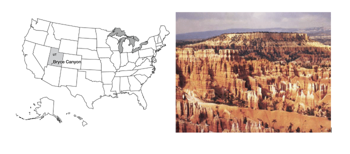
Bryce Canyon is a fairyland. Pillars, spires, and minarets, seemingly fragile and toy-like when viewed from the rim, tower far above the hiker who descends into the “canyon,” which is a bowl carved out of the edge of a plateau. The morning sun, bouncing off the pink and pastel walls, casts a rosy glow on everything and everyone in the canyon. Gnarled trees cling to high slopes, their root structure exposed by erosion but somehow holding and nourishing the twisted branches. The old settler Ebenezer Bryce called the scenery of this tributary of the Paria River “a hell of a place to lose a cow,” but almost everyone who followed him has had a kinder assessment.
The main pink rocks of Bryce are a mixture of limestones, shales, and some coarser sandstones and conglomerates, deposited in a lake or a series of lakes, and together are known as the Claron Formation or the Bryce Limestone. (Geologists studying regions have found it useful to give specific names to recognizable bodies of rock, with the names taken from geographic locations. Because the criterion for a new name is the ability to recognize a unit in the field, some careful observers like to subdivide, and others like to lump, so there is often slight disagreement as to which name is most appropriate.) These Bryce rocks are from the early part of the Cenozoic, roughly 40 million years ago. The rocks record a generally wet time shortly following the uplift of the land from a shallow seaway, and before continued uplift led to the high plateaus of today, and climate change dried the surroundings to the dry climate now at Bryce.
Some of this story is told in the rocks of Bryce. The rest is told nearby. Northeast of Bryce in central Utah, the rocks record the gradual transition from undersea to terrestrial. The growth and erosion of mountains to the west are marked by the appearance and then disappearance of coarse braided-stream deposits. These were replaced by slower streams, then by lakes, then another pulse of river sediments, and then the great Green River lakes that spread from Bryce to Wyoming and that record a wet, warm time in the west.
Geologists love to tell stories like this one. The seas came in, the seas went out, the mountains rose, and the mountains were eroded. Such stories are useful because they often include chapters such as “The oil formed here and migrated there, and was trapped in those rocks, and we can drill into it this way and get rich." (Or, the stories may involve gold, or lithium, or rare earth elements, or clean water, or other things we need). Such stories tell us much about the stability of the Earth’s climate. And the stories are interesting to many people. But how do you read such stories, and gain confidence in them? One way to find out is to major in Geosciences and spend the next three years learning to do so professionally—in case you’re interested, talk to us! But if you’re excited about the great career prospects in your current major of theatre or philosophy or whatever else you are studying, at least read over the next few sections and you’ll get a brief sketch of geological techniques and what they tell us.
We saw at the Badlands that weather attacks and breaks down rocks, and we saw at the Tetons, in Canyonlands, and elsewhere, how the loose pieces are transported. The processes of weathering and erosion produce new minerals from old, produce small pieces from big ones, produce dissolved salts, and move these around on the surface of the Earth. Eventually, these materials end up somewhere. The pieces that are derived from older rocks and the deposited we call sediment. Sediment may be deposited on the bottom of a sea, on the flood plain of a river, or at the end of a glacier. Sediment may stay for a while and then be moved on. If it stays for too long, it may be hardened.
There is no magic in making rock from sediment, nor is there an abrupt line separating the two. Many processes slowly transform loose pieces into pieces stuck together. If you don’t believe that loose pieces get stuck together, go to an old house and try to remove some piece of plumbing without using a big wrench, or try to get pieces off an old bicycle without a big wrench. If you don’t have the time, trust us—people make big wrenches for a good reason! Nature does cause changes that bond things together in many cases.
The weight of additional material deposited on top of the sediment layer will squeeze it, forcing grains together and pushing water out. The resulting material is harder than what was there before. Continued squeezing and heating as sediment is buried (remember that the Mississippi Delta is many miles thick) produce rock from this sediment and may eventually change these sedimentary rocks to metamorphic rocks. The clays in sediment change into different clays and then into other things as the cooking proceeds (just as flour and water and yeast make cookies in the oven), and as the crystals of the new minerals grow, they tend to wrap around each other and get “woven” together in an interlocking mass, so they are hard to separate.
Groundwater circulating through sediments will dissolve minerals in some places and precipitate them in others, in response to subtle changes in temperature, pressure, or chemistry. We saw that there is dissolved rock in Spring Creek water, and in all other waters. If you have “hard” water, of the sort that causes people to buy water softeners, that means the water has a lot of dissolved rock and especially dissolved limestone. The white deposit that builds up on drinking glasses in houses with hard water is not soap scum but rock, very similar to stalactites in a cave. A lot of the sticking-together of plumbing pieces is linked to minerals precipitated from hard water. What happens in your house can happen in nature, where the precipitate serves as a cement that binds particles together. This cementation, together with the compaction from squeezing and the recrystallization from heating and changing clays and other minerals, slowly turns loose sediment into sedimentary rock. Sometimes, rocks are made entirely of hard-water deposits—stalactites are an example, but so are the salt deposits containing borax and other materials left in the bottom of Death Valley when the water that runs down from the nearby mountains quickly evaporates. Rocks made entirely of precipitate are also called sedimentary rocks.
Take a Tour of Bryce Canyon National Park
Want to see more?
Here is another optional tour you might also want to take! (No, this won't be on the quiz!)
Bryce Canyon National Park
(Provided by USGS)
Classification of Sedimentary Rocks
Classification of Sedimentary Rocks
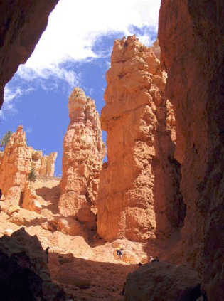
Our classification of sedimentary rocks is a bit of a hodge-podge. We first consider whether a rock is clastic (made from pieces or clasts of older rocks) or chemically precipitated (deposited from chemicals dissolved in water). This subdivision is not always satisfactory—a sea shell is a chemical precipitate because the animal pulled the material in its shell from the water, but a limestone made up of sea shells might be called clastic because the sea shells are chunks. Usually, people consider limestones and evaporites (rocks left by the evaporation of water containing salts) to be chemical precipitates, and all others to be clastics.
Clastics are classified further based primarily on grain size. The very smallest particles of clay make claystone, also called shale. Slightly coarser pieces are silt and make siltstone. Coarser still is sand, which makes sandstone. Going to still-bigger clasts, cobbles, and boulders produce cobblestone and boulder-stone, but we also call both of these conglomerates.
Conglomerate within a Conglomerate: Sevier Fault near Bryce Canyon National Park
Geologists read rocks, and the stories are fascinating--historical novels full of intrigue. In this next GeoClip, Dave Janesko and Dr. Alley perch high up in Red Canyon just west of Bryce and read one of those stories of deep time.
A conglomerate is a sedimentary rock in which many of the clasts are bigger than sand. Dave and Dr. Alley are looking at a conglomerate that includes many different clast types, including one that is itself a finer-grained conglomerate. The clasts in that conglomerate-within-a-conglomerate include several types of sedimentary rocks, including sandstones that are themselves made from older pieces.
Video: Conglomerates, Sevier Fault, Dixie National Forest (3:05)
Um, maybe. I can kind of break it out.
No, that's a conglomerate, isn't it?
Yeah. It is. Look at that, babe. That's the conglomerate we were looking for. Just look at that! Isn't that a beauty?
It is.
A conglomerate in a conglomerate. What do you make of the class in the little one?
It looks like sandstone and limestone to me.
Deep time. Deep time!
Very deep.
We got deep time! This is just beautiful.
A conglomerate classed in a conglomerate?
A conglomerate, you have to have sand grains glued together to make sandstone, broken and rolled to round them off, because this is rounded. And you have to have an ocean or a lake that has things living in it, precipitating calcium carbonate to make a limestone, broken loose and rounded off. And then those have to get together in a beach or in a stream channel. They have to be deposited with sand around them, then they have to be cemented together with hard water deposits. Then that has to be broken out, rolled in a stream and rounded, put together with all these other rocks coming from every which way. All of those then have to be glued together with hard water deposits. And then we have to get from the stream or the lake or whatever it was that was making these, up here in the middle of the desert on a cliff. And it's all in that one rock right there. And there's really no other way to explain that rock.
In geology, we often meet people who tell us that we do not know what we're talking about, that the world looks like it is very, very young, that there's nothing in the world older than written history. We never tell those people that they're wrong, that they're false, that they've been led astray. But we can tell these people, it looks old, that the scientific interpretation, the best way to look at these rocks, is that they tell of vast, deep time. So when one looks at a rock like this one that has little tiny remnants of old rocks glued together into a rock which is bounced around in the stream and rounded, that then is glued in with a whole bunch of other rocks into another rock that has been bounced around in a stream and rounded, that is sitting here glued with a bunch of these things on a cliff in the desert-- it is very hard to imagine how this could be something that is only 6,000 years old. And so all we do in science is, what can we observe? What can we test? And what we can observe, what we can test says, really, really old.
Reading Sedimentary Rocks
Reading Sedimentary Rocks
We learn about the past through sediment. Archaeologists dig up the garbage dumps and houses of past people to learn how they lived. Historians root through the intellectual sediment of people to learn what they have done. Sedimentary rocks, in the same way, tell the history of the surface of the Earth.
A typical sedimentary rock contains all sorts of clues as to how it came to be. The clast size or grain size is a measure of the energy of transport—tiny clay particles will not settle out of a swift mountain stream, so a fine-grained deposit indicates slow or no currents. Grain shape tells more—an angular clast has not been transported far in water or wind, because during transport sharp corners are knocked off and the clast becomes rounded. Sorting also tells something—wind and water sort sediments by size, but landslides and glacier ice do not, so the sand grains on a beach are all approximately the same size, but a landslide leaves a deposit that ranges from minuscule clay-sized particles up to house-sized boulders and, sadly, pieces of real houses.
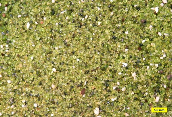
Composition provides clues—olivine is a mineral that is changed rapidly by chemical weathering and occurs primarily in low-silica igneous rocks such as sea-floor basalts, so if you find olivine grains in a sandstone, you know both that the sand was derived from such rocks, and that the sand was not transported very far in a wet environment because the olivine was not broken down. Even surface textures have information—the striations and polish of a glacier-transported rock look very different from the sand-blasted appearance of a quartz grain in a sand dune.
The sizes and shapes of deposits give further information. There are several ways to tell which way a current of wind or water was moving when it deposited a particular rock. For example, with sand dunes, the wind carries sand up a gradual slope and then dumps the sand over the top where it avalanches down and forms a steeper slope. When we find the gentle and steeper slope in the rock, we can tell which way the wind was blowing. Sand ripples and bars deposited by flowing water have similar indicators. A sand body deposited by a stream is often long and skinny in the direction the stream was flowing. A “fossil” sandy beach may be long and skinny like a stream deposit, but the current directions caused by waves will be pointing more-or-less across a beach but along a stream, so there is not much danger of confusing one type of deposit for another.
The list of indicators is very long. When mud dries out, it cracks to form mud cracks, as discussed in the Geomation and shown in the picture below. Such features are easily recognized in rocks and indicate occasional drying. Raindrops that spatter down on rocks leave little pock marks that are readily recognized if they are turned to stone and preserved.
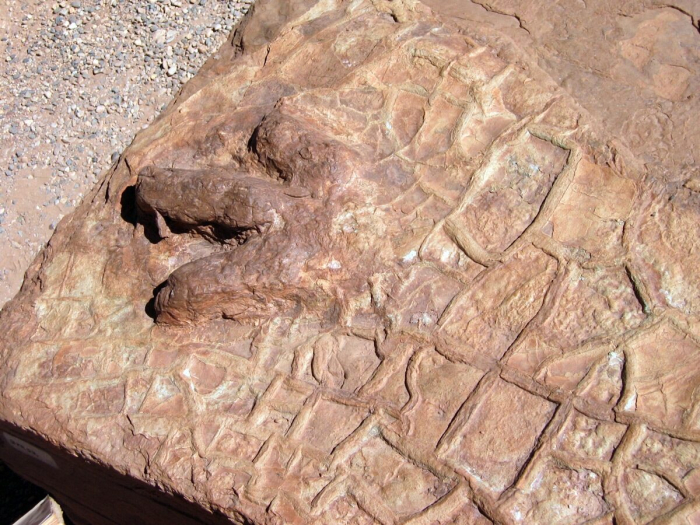
Added to this, we have the advantage of fossils. Tree trunks in growth position indicate a non-desert deposit on land—trees are replaced by cactus in desert environments, and by seaweed underwater. Coral skeletons indicate a reef in the ocean. Oysters grow in the ocean, as discussed in the Geomation just below.
ADD GEOMATION HERE
With such a wealth of information, we certainly should be able to read much of the story of the past. All that is required is that: 1) we study the rocks carefully; 2) we know what sorts of sediments are produced in what sorts of environments today; and 3) we make the common-sense assumption of “uniformitarianism”, that the present is the key to the past.
Suppose you go out today and observe that streams flow downhill and carry rock and mud from the hills to the sea. You dig around in a lot of different streams and find that they have sorted sedimentary beds, occasional fish fossils, and current-direction indicators pointing more-or-less the same way in many different sand bars, with sand bars of certain shapes and sizes and other characteristics that you can measure in many streams. You talk to people, read history books, and learn that streams have been flowing downhill and carrying rock and mud from the hills to the sea for a long time. You find a place where earlier people had diverted a stream into a canal, and you dig up the old stream bed, and find that it looks just like modern stream beds. You find still older deposits that look exactly like modern stream beds, and you find deposits in which the sand has been cemented by hard-water deposits to make sandstone, but everything else looks just like modern stream beds.
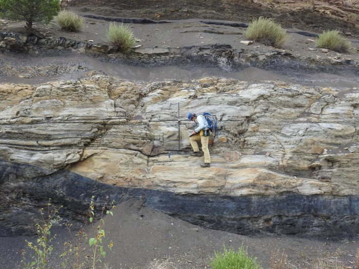
The reasonable person would say that these “fossil” cemented-to-stone stream beds are indeed old stream beds. Of course, we cannot prove that they are. Perhaps space aliens made the world the year before you were born in such a way that it looks like there were old streams, and the aliens invented all the history books and fake memories of old people. Calvin (of the Calvin and Hobbes comic strip) once told Susie that their class was having a substitute teacher because “our REAL teacher rocketed back to Saturn to report to her superiors. They’re trying to subvert us little kids with subliminal messages in our textbooks, telling us to turn in our parents when the Saturnians attack. Earth will be rendered helpless! I’m too smart for ‘em, though! I don’t read my assignments!” (To which Susie replied, “I think one of us has been eating too much paste in art class.”) Maybe Calvin is right. And maybe the Geology-of-National-Parks professors are Saturnian aliens, too! The textbook author, Dr. Alley, has really strange-looking hair where it hasn’t fallen out, and acts a bit peculiarly, you know.
However, despite his occasional interest in the topic, Calvin had not quite mastered geologic thought. Geologists take the common-sense approach: if it looks like a duck and walks like a duck, and quacks like a duck, is genetically identical to type specimens of ducks, has a bone structure as observed in x-ray examination that matches known duck bone structure, mates with other ducks and produces duck offspring, etc., we call it a duck. If it looks like a stream deposit in size, shape, arrangement, location, grain size, sedimentary structures, fossils, etc., we call it a stream deposit. We learn from the present—what streams do, what they make, where they occur—and then we use that knowledge as the key to interpreting the past.
Learning accurately from the present is not easy. By working hard in one or two advanced courses, an adept student can learn to distinguish most of the main deposits—streams versus lakes versus beaches, for example. Many geologists spend their whole lives learning what stream deposits look like, how they form, etc., while others spend their lives working on beaches, lakes, or glaciers.
When lots of these experts agree that the limestones of Bryce and its surroundings were deposited in a shallow lake and adjacent streams and mud flats, you should know that the rock type (limestone, but with differences in chemistry and texture from limestones forming in oceans), the fossils (algae, fish fossils, alligator bones, bird tracks), the structures (mud cracks, raindrop imprints), etc., have been considered carefully in telling the story. We can’t rule out Calvin’s Saturnians, but a more down-to-earth explanation is more convincing.
Arches National Park
Arches National Park
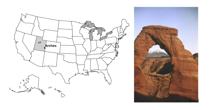
Arches National Park is just outside of Moab, Utah, almost within shouting distance of Canyonlands. Arches National Park has the largest concentration of natural stone arches in the world, with dozens of major arches, numerous other holes, and many more interesting rock features. The longest natural arch in the USAis there, Landscape Arch, spanning about 300 feet (almost 100 meters). Several rockfalls have occurred from Landscape Arch since European settlers arrived, reducing the arch to a thickness of only 11 feet (3 m) in its thinnest part. The trail under the arch has been closed; the Park Service knows that eventually more rocks, and the whole arch, will fall, and the rangers do not wish to be involved in extracting compacted humans from beneath the remnants of what used to be the USA’s longest arch.
The arches are all eroded in sandstone, especially the mid-Mesozoic (deposited during the time of dinosaurs) Entrada Sandstone, which includes both marine and wind-blown sands. Arch formation started with the deposition of thick beds of salt in the Arches area. Sediments including the Entrada sands were deposited on top of the salt, and cemented by hard-water deposits to make sandstone. When the weight of those sediments became large enough, the salt began to flow, squeezed from places where thicker sediments caused higher pressure on the salt, to places where thinner sediments gave lower pressure, like ketchup in a fast-food packet squeezed from one place to another. However, the foil wrapping of a fast-food packet is fairly flexible, but the Entrada sandstone was not, so as the salt moved, the tough sandstone broke, forming cracks called joints. The most common joints formed by this motion are parallel, nearly vertically oriented, and a few yards (or meters) apart. Weathering processes attacked the rocks along these joints, which were slowly widened to leave vertical slabs of rock called fins.
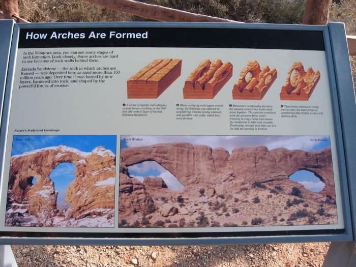
Some weathering and erosion processes are more effective near the ground than high up. For example, you will see huge steel bolts sunk into the rock of some road cuts just above the highway to keep the weight of the rock above from popping slabs of rock loose that might blast into the road and kill people; such rock-bursts also occur in quarries if actions are not taken to avoid them. When such slabs of rock break from a cliff or fin or fall, they often leave a curved or arch-like top, because it is easier to break off a curve than a square-cornered piece. This process is among those that contribute to the arch formation, breaking through the fins to make beautiful stone arches.
Stratigraphy
Stratigraphy
The earlier text says that the Entrada Sandstone is from near the middle of a time we call the Mesozoic, an Era of geologic history, and for Bryce, our text told you that Bryce Limestone is from early in the Cenozoic Era of geologic time. You have not been asked to learn these terms yet (but you will be, so you might want to lodge them in your brain now). The Mesozoic is older than the Cenozoic, so the Entrada is older than the Bryce. How do we tell which layers are older or younger?
Putting rocks in order is an enjoyable puzzle requiring the logic used in sudoku or crossword puzzles. You rely on a few general principles that boil down to common sense, plus a lot of puzzling, looking, and thinking. Start with “What’s on top”? As we saw with Hurricane Katrina in New Orleans, the layer of mud that settles out of floodwaters is deposited on top of the mud, grass, floor tiles, and grand pianos of the floodplain. Naturally, the mud from the next year's flood is deposited on top of the mud from this year (nature doesn’t clean off the grand piano). In ordinary sedimentary rocks, the youngest rocks are on top and the oldest are on the bottom. We call this the Principle of Superposition.
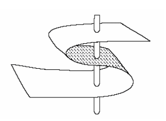
Note that this applies to ordinary rocks. There are cases in which rocks are turned upside down. Take a sheet of paper on your desk, put your fingers on opposite sides, and squeeze your fingers and the ends of the piece of paper towards each other (see the figure above). The paper will buckle into a fold. If you can get your fingers close together, the fold may “fall over”. A vertical hole through your paper would now go through the top of the page and out the bottom, then through the bottom of the page and out the top, before finally going through the top and then the bottom—going from top to bottom, the paper is right-side up, then upside-down, then right-side up (look at the figure again).
Fortunately, many “up” indicators in rocks tell you which way was up when the rock was formed. Animal tracks and raindrop imprints are made down into mud, not up. If you find a track pressed up into the roof of a cave, it is reasonable to suppose that the track originally went down but then has been turned over, so it is now upside-down. (Bats can hang from the ceiling, but dinosaurs did not walk upside-down on cave ceilings!) Mud cracks get narrower going down and disappear at the bottom, not the top. Curved clam shells are usually flipped by currents into the stable, hollow-side-down configuration, rather than the rocking, hollow-side-up configuration. Bubbles in lava flow rise to the top where they are trapped just beneath the quick-cooled upper surface; the bubbles do not sink down to the bottom. (We saw a little of this with the dinosaur track and mud cracks in the picture on the Bryce page, and you will meet more of this in the Rockin' Review of this chapter and also in Exercise 4. So if you are having trouble visualizing any of it, stay tuned for more.) Hence, you can learn whether the rocks have been turned upside-down or not.
In clastic sedimentary rocks, the clasts must be older than the rock. So a conglomerate containing pieces of granite and other things tells of the formation of granite from melted older rock, followed by physical erosion to break the granite into pieces, followed by transport to mix the granite pieces with chunks of other rocks, followed by deposition of the chunks followed by hard-water cementation to make the conglomerate rock. A conglomerate containing pieces of sandstone from a beach tells of two cycles—make the sand from older rocks (perhaps from the breakdown of granite by chemical weathering), followed by transport of the sand to a beach, followed by cementation of the sand with hard-water deposits to make sandstone, followed by physical weathering of the sandstone to make sandstone chunks, followed by transport of the chunks and mixing with others and deposition and cementation to make the conglomerate. In the video with Dave Janesko earlier in this module, a conglomerate contained a clast of an earlier conglomerate that contained clasts of still earlier sedimentary rocks. If a fault has split a granite clast in a conglomerate, and moved one side relative to the other so that the pieces no longer match, the fault must be younger than the conglomerate—something must exist before you can break it. If a layer of sandstone is standing on edge then it must have been deposited, hardened, and then tilted—because of mass-movement processes, layers are nearly horizontal when deposited (not exactly, but pretty close); if you tip a mud layer up on end before it has hardened, it spreads into a new, nearly horizontal layer.
Below is a photograph of an outcrop near I-70 in the near-desert conditions of central Utah (shown on the left), and a sketch of the outcrop (shown on the right). The rocks at the bottom were deposited on a sea coast—they contain marine fossils and other markers of the sea and are mostly sandstone and shale. But they are standing on edge and truncated at the top. Developed on the top of them is a soil, and on top of that are lake deposits with flamingo bones, fish fossils, and alligator bones.
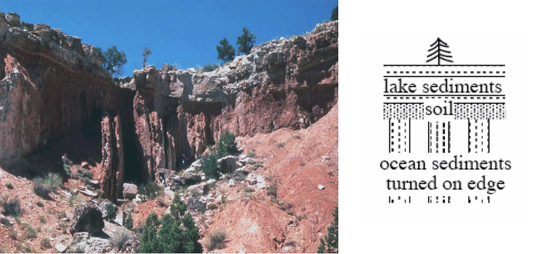
The story of this outcrop includes:
- Some history to produce sand and mud and deliver them to the sea, where they were deposited and then hardened;
- A mountain-building episode to turn the rocks up on edge;
- Erosion to truncate the rocks, together with weathering to create the soil;
- Growth of a lake, with sediment accumulation in the lake;
- Drying or draining of the lake; and
- Erosion revealing the cross-section of the deposits that you see.
You can postulate many other things—Dr. Alley is just lying about the rocks; or, the space aliens put the rocks there; or, a giant tornado blew the rocks there one afternoon; or…. We humans are very inventive, and can always come up with a new idea. But when you follow out the implications of these other stories, some fundamental problem always comes up, whereas the story of the rocks being deposited and hardened and tipped on end and eroded and so on works just fine, and makes predictions that are borne out over and over. Hence, the “geological” or “scientific” interpretation is the sensible one.
Notice that the erosion surfaces [events 3 and 6 in the list above] represent time gaps in the sedimentary sequence; the rocks at this site do not have a record of the environment during the time erosion was occurring—you have to go to where rocks were being deposited to learn that. A time gap in a sedimentary sequence, whether from actual erosion or just lack of deposition, is called an “unconformity”. Most of the land experiences erosion most of the time—the mud in the Mississippi is eroded from the lands upstream, and most of us most of the time do not have to worry about mud being deposited on our grand pianos or carpets. But some sediments are deposited somewhere on land most of the time, and sediments are deposited almost everywhere almost all the time under the sea, allowing a fairly complete story to be told.
Fossils and Relative Time: The Law of Faunal Succession
Fossils and Relative Time: The Law of Faunal Succession
The text above explains how geologists can put rocks in time order from oldest to youngest. The job may be quite difficult, because some outcrops are covered by soil, water, or other rocks, because offsets on faults may be so large that rocks on opposite sides can’t be matched back up easily (remember the bear in Cade's Cove way back in the Great Smoky Mountains), etc. But the job can be done, tested, and found to be correct.
When this job is done, a remarkable result emerges. Many rocks contain fossils, and different rocks contain different fossils. Arranging the rocks in order reveals that the fossils also are arranged in order. Rocks of similar age from similar environments have similar fossils; rocks with a greater age difference also have a greater difference in their fossils. The younger a fossil is, the more it resembles things living today. This scientific result, that fossils succeed one another in a definite and recognizable order, is called the Law of Faunal Succession. “Law” here is not something passed in Congress; a scientific “law” such as this one is a successful summary of an immense number of different observations, and works very well in explaining and predicting many different things in many places and times.
The Law of Faunal Succession was developed in England by a 17th-century canal engineer/geologist named William Smith. He faced practical problems; digging in some rocks is easier than in others, some rocks hold canal water better than others, etc. If he crossed a river into a region where all the rocks were buried beneath soil and thus difficult to study, he wanted to know whether the rocks under that soil were the ones he wanted to build in, or whether the ones he wanted were younger or older, higher or lower, in the pile of rocks. Sometimes, a few fossils would be evident in a streambed or elsewhere. (He even checked on fossils that local farmers were using as weights for balances to weigh cheese!). He found that the fossils made his job easier by providing shortcuts for putting things in order.
Much later, faunal succession figured in the development of our understanding of biological evolution. But, remember that the Law of Faunal Succession is like so much good science—a practical idea that gives useful results and helps humans do things successfully.
The Geologic Time Scale
| Era | Period | Age since end of period(Years) |
|---|---|---|
| Cenozoic = New Life (Age of Mammals) | Quaternary, Tertiary | 0 (present time) |
| Mesozoic = Middle Life (Age of Dinosaurs) | Cretaceous, Jurassic, Triassic | 65 million years ago |
| Paleozoic = Old Life (Age of Shellfish) | Permian, Pennsylvanian, Mississippian, Devonian, Silurian, Ordovician, Cambrian | 225 million years ago |
| Precambrian = Before Cambrian (Age of Algae) | None Listed | 570 million years ago |
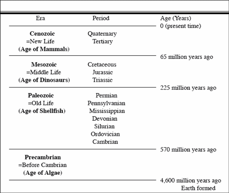
Geologists learned to put rocks and fossils in order long before calendar-year ages could be assigned accurately (how many years old is that?). Lacking accurate year counts, the early geologists agreed on a “shorthand” for describing ages. Time is divided into big chunks, called “eras,” which are divided into smaller chunks, or “periods,” and on into still smaller chunks. The big chunks (which you would be wise to know) are, from youngest to oldest, the Cenozoic (= new life), the Mesozoic (= middle life), and the Paleozoic (= old life).
The oldest period in the Paleozoic is called the Cambrian, and the rocks older than it are called the Precambrian. As the Precambrian includes most of the history of the Earth, more and more workers are using “-zoic” terms for pieces of it (see the Enrichment). The periods are mostly named for places where the rocks are well-exposed and where they were studied by early geologists, such as the Cambrian for Cambria (also known as Wales, a region to the west of England in the United Kingdom), Devonian for Devonshire in southwestern England, and the Pennsylvanian for Pennsylvania (Europeans usually lump the Mississippian and Pennsylvanian together and call that lump the Carboniferous, but the USA has such wonderful deposits of this age that we divide the Carboniferous to allow better time resolution). The youngest two periods are the Paleogene (“old generation”) and Neogene (“new generation”). In older reference works, you may see the Paleogene and the first part of the Neogene referred to as the Tertiary, with the more-recent part of the Neogene called the Quaternary; science progresses, but old books and old web sites often are not updated.
Life appeared early in the Precambrian, and multicelled organisms were present in the Precambrian. The Cambrian began with a great diversification of organisms with shells. Fossils older than the Cambrian are relatively rare because soft body parts usually are not fossilized; when shells appeared, they accumulated to make limestone layers, so fossils “suddenly” (over a few million years) became common. (But thanks to a lot of work, many fossils are known from the Precambrian now!). The Paleozoic and the Mesozoic ended with mass extinctions that probably killed a majority of organisms on Earth (we’ll return to this soon). The mass extinction at the end of the Mesozoic was caused by a meteorite impact. The mass extinction at the end of the Paleozoic was caused by global warming and chemical changes linked to a vast outpouring of carbon dioxide and other materials from the largest known flood basalt event in geological history.
Take a Tour of Arches National Park
GeoMations and GeoClips
All of the geomations/geoclips except these two were moved to content pages. Is there a place in the Module 9 content where you would recommend we place these two? I noticed we don't mention Capital Reef National Park in this Module.
Oysters! - Capitol Reef National Park
Rocks reveal how and where they were formed. Clues to the history of rock come from how it is put together, whether the pieces are big or little, sorted or mixed, angular or rounded, and so much more. Fossils also provide clues. Here, Dr. Alley and the CAUSE class are out in the desert at Capitol Reef National Park, but they are also in a shallow seaway from long ago. See why.
So we've been driving around the West, pointing at rocks-- there's a rock-- and saying, this is a sand dune. This is a lake. This is an ocean. But we haven't spent a lot of effort on, why do we say one is a sand dune, and one is a lake, and one is an ocean? Now in the case of the sand dune, when we looked at it, it was all sand. There were no little pieces, there were no big pieces, it was all intermediate size sand pieces. They had these structures that one sees in modern sand dunes. If you found anything that looked like a fossil, it was little reptile tracks. And so they had all the characteristics that you see in a modern sand dune.
Now here, we're in rocks that are very different. The rocks behind us are sort of washing away and they're making mud that washes down around our feet. And there's a number of characteristics of these, the layers are different, how big the grains are in them is different, sort of everything about them is different. And we can say these were rocks that were underwater. And we can go through the whole list of reasons why we can say they're underwater, but there's one very easy one. If we look down at our feet, and we look around at what's washing out of these rocks, what we find is oysters. And one can be very confident that if you find rocks full of oysters, you're not in the middle of the desert.
Mud Cracks - Capitol Reef National Park
Rocks occasionally are turned upside-down, but nature tells us when that happens. Mud cracks can show us that; they are wide at the top, narrow, and then end at the bottom. Fill mud cracks with another layer of sand or mud, and the cracks are "fossilized," to tell us which way was up when the rocks were deposited. Here, visit Capitol Reef with Dr. Anandakrishnan to see mud cracks, with a brief look at some right-side-up ones from the Grand Canyon.
[MUSIC PLAYING]
Look at this picture. You've got all these cracks developed over here. Imagine a second flood coming through here, a relatively gentle flood, water slowly flowing in here, a new layer of silt and sand and shales and clays. What's going to happen? All of that new material is going to filter down into these cracks and it's going to solidify in there as the water evaporates out of it.
So now 100 million years goes by. And we come along and we cut this open and we look at this layer and we look at these, and you'll see mud cracks. And we'll be able to tell that that layer of rock was oriented this way, because these mud cracks all start wide at the top and get narrow going downwards. And it quite often happens that these strata of rock, because of the incredible forces of nature of plates coming together, will take these layers and just flap them over upside-down. And we come along and we look at them, and you can't tell which way is up, which way is down until you find one of these mud cracks.
And then, even if the layer's upside-down, then you'll have these mud cracks teepeeing upwards. And you'll say, whoa-ho, this thing must've been flopped over and turned over upside-down. And it's the same processes-- I'm doing a Richard here. It's the same processes that produce these mud cracks, will fill them in, and then maybe after 100 million years, they'll get fossilized, turned into a hard clay layer, and then turned upside-down. But we'll still be able to tell what we call the stratigraphic relationship, the time relationship, which is older, which is younger, because clearly this is older than whatever would lay on top of it.
[MUSIC PLAYING]
Deep Time GeoClips (optional)
Deep Time GeoClips (optional)
During three weeks in May 2004, two hardy Penn State geoscientists traveled through 12 stunning National Parks of the southwestern United States with 13 great students. The trip was sponsored by CAUSE (Collaborative Active Undergraduate Student Experience), an annual course offered by the College of Earth and Mineral Sciences. Professor Richard Alley and Sridhar Anandakrishnan led the expedition. CAUSE 2004 was an extension of his course, "Geology of National Parks," and allowed students to interact with and learn from the rocks and landscapes of Arizona, Utah, and Colorado. In the following videos, Alley explains the concept of deep time, how it tells the history of our planet, and how it affects our lives.
Richard Alley, Ph.D., is Evan Pugh professor of geosciences in the College of Earth and Mineral Sciences, rba6@psu.edu.
—Emily Rowlands
What is Deep Time?
Deep Time and Beliefs
Deep Time and Climate Change
Deep Time and You, Part 1
Deep Time and You, Part 2
Optional Enrichment Article
Optional Enrichment Article
The Cenozoic, Mesozoic, and Paleozoic Eras are lumped together into the Phanerozoic Eon; “Phanerozoic” is from Greek roots meaning that life showed itself. The Phanerozoic started with the fairly sudden (over a few million years) appearances of common shells, which greatly “improved” the fossil record. You have to look hard to find the remains of a jellyfish in a rock, but with shells, the remains are the rock. Going back in time before the Phanerozoic are the Proterozoic (earlier life), the Archean or Archeozoic (beginning life; different people prefer to use the different words, Archean or Archeozoic), and the Hadean (like Hades; hellish).
The Hadean, from about 4.55 or 4.6 billion years to about 3.8 billion years ago, probably experienced such huge meteorite impacts that they vaporized the whole ocean and some rocks as well. Life would have had great difficulty surviving such catastrophes.
Life was present by the beginning of the Archean, about 3.8 billion years ago. The central regions of the continents had formed by the end of the Archean, about 2.5 billion years ago. Oxygen remained scarce or absent in the atmosphere and ocean, and carbon dioxide helped keep the world warm under the young sun that was not as bright as today.
In the Proterozoic, oxygen from cyanobacteria and other microbes “rusted” the oceans. Iron rusts with oxygen, but in the oxygen-poor world of the Archean, iron dissolved and washed into the ocean rather than rusting. As oxygen was released by photosynthesis, the iron was rusted and fell to the bottom to form the great banded iron formations that we mine today in Minnesota, Australia, and elsewhere.
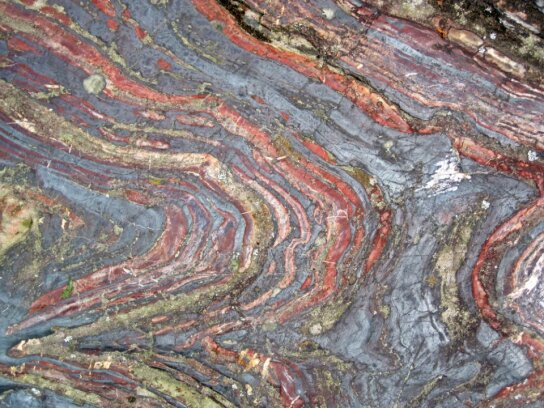
Oxygen then increased in the atmosphere. At first, oxygen was a poison to many living things because it is so highly chemically reactive. However, oxygen proved to be highly valuable as life figured out how to use the “new” chemical, allowing the development of larger organisms. Oxygen also shields all organisms from damaging ultraviolet rays by giving rise to protective ozone in the stratosphere. As oxygen rose in the atmosphere it removed other gases from the atmosphere by combining with gases there that were stable without oxygen. Some of those were strong greenhouse gases. Back then, the sun was not as bright as it is now, and warm temperatures were maintained by an atmosphere with more greenhouse gases than today. Carbon dioxide probably was still the most important, but others including methane probably contributed more than they do today. Removal of the methane and perhaps other complex greenhouse gases may have caused the “snowball Earth” events that nearly froze the planet.
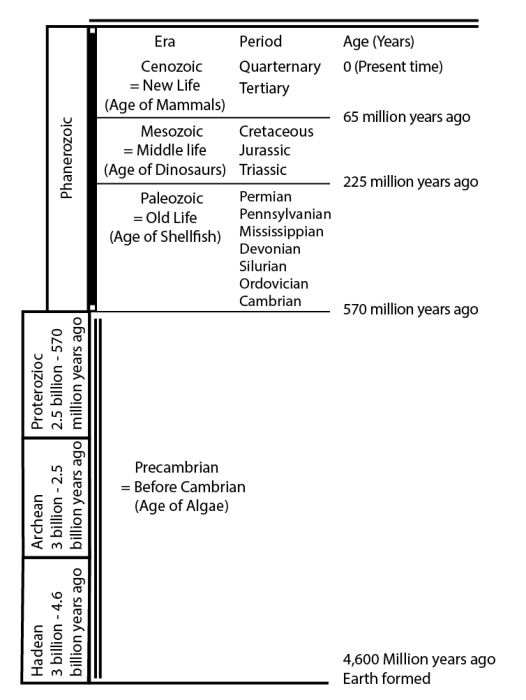
| Era | Period | Age (Years) |
|---|---|---|
| Cenozoic = New Life (age of mammals) |
Quaternary Tertiary |
0 (present time) |
|
Mesozoic = Middle Life |
Cretaceous |
65 million years ago |
|
Paleozoic = Old Life |
Permian |
225 million years ago |
| Era/Period | Age |
|---|---|
| Proterozoic | 2.5 billion - 570 million years ago |
| Archean | 3 billion - 2.5 billion years ago |
| Hadean | 3 billion - 4.6 billion years ago |
Want to see more?
What do beauty, saving money at Las Vegas, religion, oil exploration, emerging new diseases, and the planet’s recovery from global warming have in common? All in some way involve deep time, the immense age of the Earth. Eric Spielvogel filmed a discussion of these and other issues with Dr. Alley, for a special “time” issue of Research! Penn State. The Deep Time film clips on the previous page will give you something to think about, and may even help with the course. Enjoy! (No, these won't be on the quiz either!)
Sedimentation Models
(An extensive collection of animations on this subject)
Sequence Stratigraphy
(An extensive collection of animations on this subject)
A Rocking Review
A Rocking Review
Here's another look at learning which way is "up" when a rock layer is deposited. Dance on down with the dinosaur in this parody of Neil Sedaka's "Breaking Up Is Hard To Do".
Video: Down-Doo-Bee-Doo (3:19)
PRESENTER: If all that dancing has your head spinning so fast that you can't tell up from down, then this next song is just what you need. It was Neil Sedaka who said it first, "down, doo-bee-doo-down-down."
(SINGING) Footprints sink down, doo-bee-doo-down-down. Mudcracks grow down, doo-bee-doo-down-down. Raindrops imprint down, doo-bee-doo-down-down. They tell us which started up.
Don't let confusion rule your mind if footprints in the ceiling you find. 'Though mountain building turns it all around, the dinos always put their feet down. When sand falls behind a dune, a big gust blows the top off soon. And when the old dune sits beneath the new, the cut end started up. It's true!
They say that reading rocks is hard to do. Don't believe it. We know it's not true. No mountain building turns rocks over or on end. We know this occurred because the footprints started down, my friend.
Bubbles rise up, doo-bee-doo-up-up. Cross-bed cut-ends up, doo-bee-doo-up-up. Shells rocker-sided up, doo-bee-doo-up-up. They tell which way started down.
Take a look at a lava flow. Crust forms on top while it's soft below. The bubbles rise, but they can't get out. Lots of big ones near top, no doubt.
If cross-bed cut-ends don't point up or clamshell pieces make a loving cup, don't be alarmed, and don't wear a frown. The rock is just turned upside down. For history, you must know which came last, which came first in the distant past. Geologists can put 'em in a all in a row, 'cause the dinosaurs all put their feet down we know.
Footprints sink down, doo-bee-doo-down-down. Mudcracks grow down, doo-bee-doo-down-down. Raindrops imprint down, doo-bee-doo-down-down. They tell us which way started up.
Module 9 Wrap-Up
Module 9 Wrap-Up
Review Module Requirements
You have reached the end of Module 9! Double-check the list of requirements on the Welcome to Module 9 page and the Course Calendar to be sure you have completed all the activities required for this module.
Reminder
Exercise #4 is due and Exercise #5 opens this week. See the Course Calendar for specific due dates.
Supplemental Materials
Following are some supplementary materials for Module 9. While you are not required to review these, you may find them interesting and helpful in preparing for the quiz!
- Website: Arches National Park
- Website: Bryce Canyon National Park
Comments or Questions?
If you have any questions, send an email via Canvas, to ALL the Teachers and TAs. To do this, add each teacher individually in the “To” line of your email. By adding all the teachers, the TAs will be included. Failure to email ALL the teachers may result in a delayed or missed response. For detailed directions on how to do this, see How to send an email in GEOSC 10 in the Important Information module.