Prioritize...
At the completion of this section, you should be able to list and describe the three precipitation factors that affect radar reflectivity, and use them to interpret radar images. You should be able to explain why hail causes very large reflectivity values while snow tends to be under measured. You should also be able to explain the difference between "base reflectivity" and "composite reflectivity."
Read...
Now that you know how a radar works, we need to discuss how to properly interpret the returned radar signal. As with any remote sensing tool, we have to understand what factors influence the amount of radiation that is received by the instrument. As you recall, radar works via transmitted and returned microwave energy. The radar transmits a burst of microwaves and when this energy strikes an object, the energy is scattered in all directions. Some of that scattered energy returns to the radar and this returned energy is then converted to reflectivity (in dBZ). Ultimately, the intensity of the return echo (and therefore, reflectivity) depends on three main factors inside a volume of air probed by the radar "beam":
- the size of the targets
- the number of targets
- the composition of the targets (raindrops, snowflakes, ice pellets, etc.)
Allow me to elaborate a bit on each of these factors impacting radar reflectivity. For starters, the size of the precipitation targets always matters. The larger the targets (raindrops, snowflakes, etc.,) the higher the reflectivity. By way of example, consider that raindrops, by virtue of their larger size, have a much higher radar reflectivity than drizzle drops (the tiny drops of water that appear to be more of a mist than rain). Secondly, the power returning from a sample volume of air with a large number of raindrops is greater than the power returning from an equal sample volume containing fewer raindrops (assuming, of course, that both sample volumes have the same sized drops). The saying that "there's power in numbers" certainly applies to radar imagery!
To see how the size and number of targets impact reflectivity, consider this example. Many thunderstorms often show high reflectivity on radar images, with passionate colors like deep reds marking areas within the storm with a large number of sizable raindrops. A large number of sizable raindrops falling from a cumulonimbus cloud also leads to high rainfall rates at the ground typically. Thus, high radar reflectivities are usually associated with heavy rain.
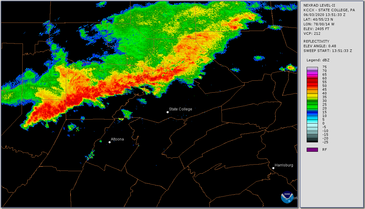
The radar image above shows a line of strong thunderstorms (called a "squall line") approaching State College, Pennsylvania from the northwest, with radar reflectivity exceeding 55 dBZ in some areas. Such high reflectivities are typically associated with very heavy rainfall, but inferring specific rainfall rates from radar images can be tricky business. A given reflectivity can translate to different rainfall rates, depending on, for example, whether there are a lot of small drops versus fewer large drops.
The presence of large hail in thunderstorms can really complicate the issue of inferring rainfall rates from radar reflectivity even more. Typically, radar reflectivity from a thunderstorm is greatest in the middle levels of the storm because large hailstones have started to melt as they fall earthward into air with temperatures greater than 0 degrees Celsius (the melting point of ice). Covered with a film of melt-water, these large hailstones look like giant raindrops to the radar and can have reflectivity values higher than 70 dBZ. The bottom line is that higher reflectivity usually corresponds to higher rainfall rates, but the connection is not always neat and tidy.
Okay, lets move on to the final controller of radar reflectivity -- composition. The intensity of the return signal from raindrops is approximately five times greater than the return from snowflakes that have comparable sizes. Snowflakes have inherently low reflectivity compared to raindrops, so it's easy to underestimate the area coverage and intensity of snowstorms if you're unaware of this fact. It might be snowing quite heavily, yet radar reflectivity from the heavy snow might be less than from a nearby area of rain (even if the rainfall isn't as heavy) because the return signal from raindrops is more intense.
There's another way that moderate to heavy snow falling within the range of the radar can be camouflaged. Indeed, precipitating stratiform clouds are often shallow (not very tall), which means that the radar beam will sometimes overshoot snow-bearing clouds located relatively far away from the radar site. To see what I mean, check out the short video (1:40) below.
Click here for a transcript of the video.
PRESENTER: Let’s look at an example of how radar imagery can sometimes be misleading when snow is falling. This is a reflectivity image from the radar located in Cleveland, Ohio, and from this image, it might be tempting to think that heavy snow might be limited to here east of Cleveland where reflectivities are around 35 dBZ. At greater distances from the radar, reflectivity decreases to less than 10 dBZ at places like Toledo and Findlay.
But, because the precipitating stratiform clouds that produce snow are often shallow, the radar beam, which is increasing in elevation as it gets farther from the radar site, can sometimes overshoot snow-bearing clouds partially or entirely when they are located relatively far from the radar site. In other words, the radar scans the very tops of snow bearing clouds, where there are relatively few precipitation targets, or it misses them entirely, leading to either low reflectivity or no reflectivity at all.
Our radar image was from 12Z, and the meteogram from Findlay, Ohio showed that 12Z fell during a period of heavy snow in Findlay. So, it was snowing heavily at the time of our radar image.
Yet, our radar image showed reflectivity of less than 10 dBZ at Findlay. Findlay is located about 100 miles from the radar’s location in Cleveland, so it was far enough away that the radar beam was mostly overshooting the snow-bearing clouds, leading to conditions at the ground – heavy snow – that didn’t match our expectations from radar reflectivity.
The fact that radar sometimes overshoots snow-bearing clouds can really challenge forecasters (sometimes with deadly consequences), as this short segment from Penn State's Weather World program illustrates (check it out if you're interested). To further complicate interpreting radar images, I point out that partially melted snowflakes present a completely different problem to weather forecasters during winter. When snowflakes melt, they melt at their edges first. With water distributed along the edges of the "arms" of melting flakes, partially melted snowflakes appear like large raindrops to the radar. Thus, partially melted snowflakes have unexpectedly high reflectivity. For much the same reason, wet or melting ice pellets (sleet) also have a relatively high reflectivity.
Therefore, during winter, radar images sometimes show a blob of high reflectivity embedded in an area of generally lower reflectivity. Often, this renegade echo of high reflectivity is partially melted snow or sleet, and it's a good idea to check surface observations to see whether the relatively intense echo is indeed partially melted snow or sleet, or an area of moderate to heavy rain. For example, check out this band of high reflectivity just south of St. Louis, Missouri. Nearby Scott Air Force Base in Belleville, Illinois ("BLV" on the map) was in the midst of this band, and at the time of the radar image the Belleville meteogram showed a rather unusual current weather symbol, representing "snow pellets" (partially melted snowflakes that have refrozen). The bottom line is that forecasters must be careful interpreting radar images when snow might be falling.
Base Versus Composite Reflectivity
For a powerful thunderstorm that erupts fairly close to the radar, a scan at 0.5 degrees would likely intercept the storm below the level where the most intense reflectivity occurs. Such a single, shallow scan falls way short of painting a proper picture of the storm's potential. As a routine counter-measure, the radar tilts upward at increasingly large angles of elevation, scanning the entire thunderstorm like a diagnostic, full-body MRI.
The radar can tilt upward to angles of elevation as large as 19.5 degrees, as indicated in the figure below, which shows the elevation scans in a common "general surveillance" radar mode. But, the series of elevation scans shown below isn't the only option that National Weather Service NEXRAD units have; they are programmed with multiple scanning strategies to give forecasters the most useful data depending on the weather situation. A complete scan like the one shown below takes about 6 minutes, which means that under normal circumstances, forecasters must wait about 6 minutes to get a look at the newest radar scan at each elevation. But, during severe weather, forecasters desire more frequent low-elevation scans to better see what's happening in the lower parts of thunderstorms. So, the radar can be switched into "SAILS" mode, which causes the radar to interrupt its scanning progression to give more low-level scans, providing forecasters with more frequent updates on the lowest elevation scan.
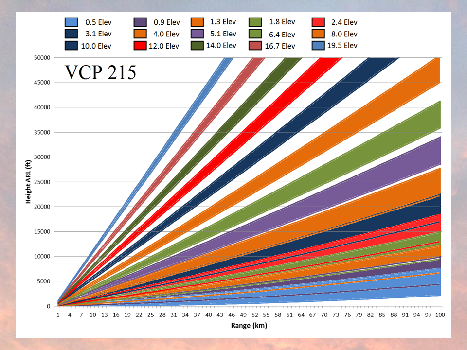
On the image above showing how the radar can tilt upward at increasingly large angles, the numbers at the top represent the standard angles included as part of the general surveillance scan. Also note the colorful "beams," which represent the approximate width and length of the radar scan as a function of distance from the radar site. Again, note how wide the "beam" becomes at great distances from the radar.
Meteorologists describe the radar reflectivity derived from a single scan as base reflectivity, and the most common base reflectivity corresponds to the scanning angle of 0.5 degrees. The National Weather Service also provides images of composite reflectivity, which represents the highest reflectivity gleaned from all of the individual scan angles.
To see how one scan angle can have a higher reflectivity than another, consider the case of a severe thunderstorm. The storm's updraft, which is a fast, rising current of moist air that sustains the thunderstorm, is usually strong enough (25 meters per second or faster) to suspend a large amount of rain (and hail) aloft. Meteorologists call the suspension of precipitation high in a thunderstorm precipitation loading. At this stage of the storm, the reflectivity high in the cumulonimbus cloud is much greater than the reflectivity lower in the cloud. So, a radar image created from composite reflectivity will likely display the higher dBZ level (more intense colors) than a radar image of base reflectivity. Eventually, of course, the rain intensity at lower altitudes (and the surface) will increase as rain and hail fall from the cloud (this will occur once the updraft can no longer support the weight of suspended water and ice).
For example, check out the image below. This graphic shows radar reflectivity plots of a garden-variety thunderstorm at four different scan angles. First, note that the core radar reflectivity on the upper-right panel (scan angle of 1.5 degrees) was higher than the core base reflectivity at 0.5 degrees (upper-left panel). Comparing the two images, we conclude that the heaviest precipitation was higher up in the thunderstorm at this time.
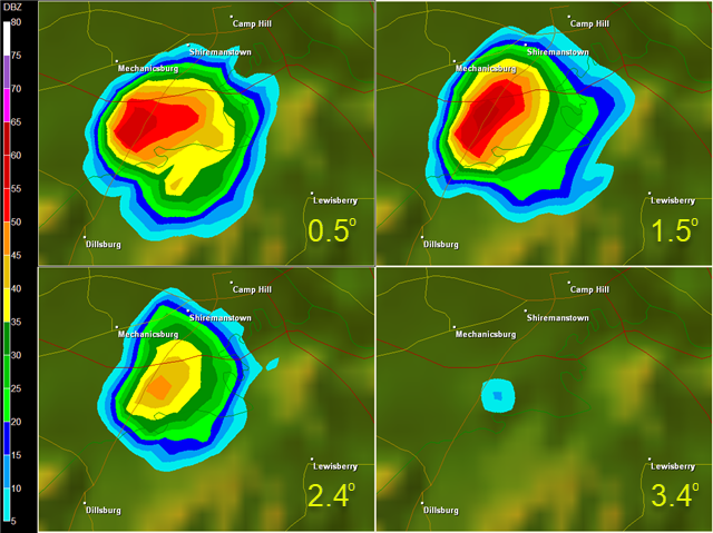
Note that the radar reflectivity markedly decreased at a scan angle of 2.4 degrees (lower-left panel). When the scan angle was set to 3.4 degrees (lower-right panel), the reflectivity all but vanished, indicating that there weren't many precipitation particles near the top of the storm.
Here's one last example of how composite reflectivity can be higher than base reflectivity. On August 30, 2023, Hurricane Idalia made landfall in northern Florida. The 1206Z composite reflectivity (on the left below) generally shows larger areas of 35 dBZ or more (yellows, oranges, and reds) compared to the corresponding base reflectivity image on the right. Furthermore, the base reflectivity image showed an area with no reflectivity within the storm's circulation southeast of the radar site, while composite reflectivity was as high as 20 to 30 dBZ in the same area (which the radar had detected during a higher elevation scan).
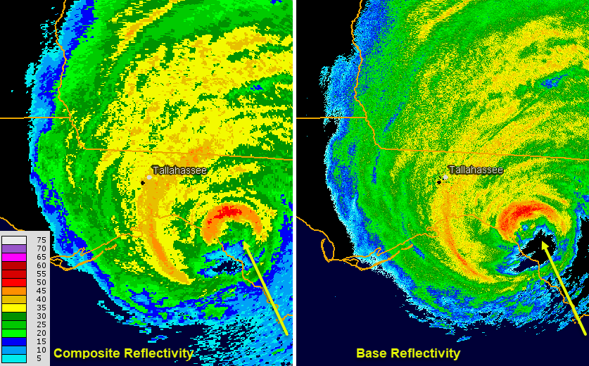
Composite reflectivity may not be representative of current precipitation rates at the ground, but it can show the potential if the precipitation causing the highest reflectivity (often well up into the cloud) can fall to the surface.You might think that this discussion is probably too much "inside baseball," but composite reflectivity is the mode of choice on regional or national mosaics that you frequently see on the Web, in mobile apps, and on television. So, the bottom line is to make sure that you know which type of radar product you are looking at before performing any kind of analysis.
Now you know the basics of interpreting radar imagery, and we're just about ready to wrap-up our lesson. Before you finish up, however, test your knowledge of basic concepts from this section in the Quiz Yourself section below. You may also be interested in the Explore Further section below, where you can find out more about some common radar products (precipitation-type images and satellite-radar composites) that you'll commonly encounter on television and online.
Quiz Yourself...
Feeling confident in your basic knowledge of radar interpretation? Take this quiz to see how you do. You'll need to apply these concepts on various assignments.
Explore Further...
Commonly, regional or national radar mosaics visually distinguish areas of rain from snow and mixed precipitation (any combination of snow, sleet, freezing rain, and/or rain) using different color keys. Note that rain, mixed precipitation, and snow each has its own color key in the regional radar mosaic below. While the exact methods for creating such images vary, they all start with radar reflectivity and often incorporate other radar products along with surface temperature and other lower tropospheric observations to give a "best guess" of precipitation type.
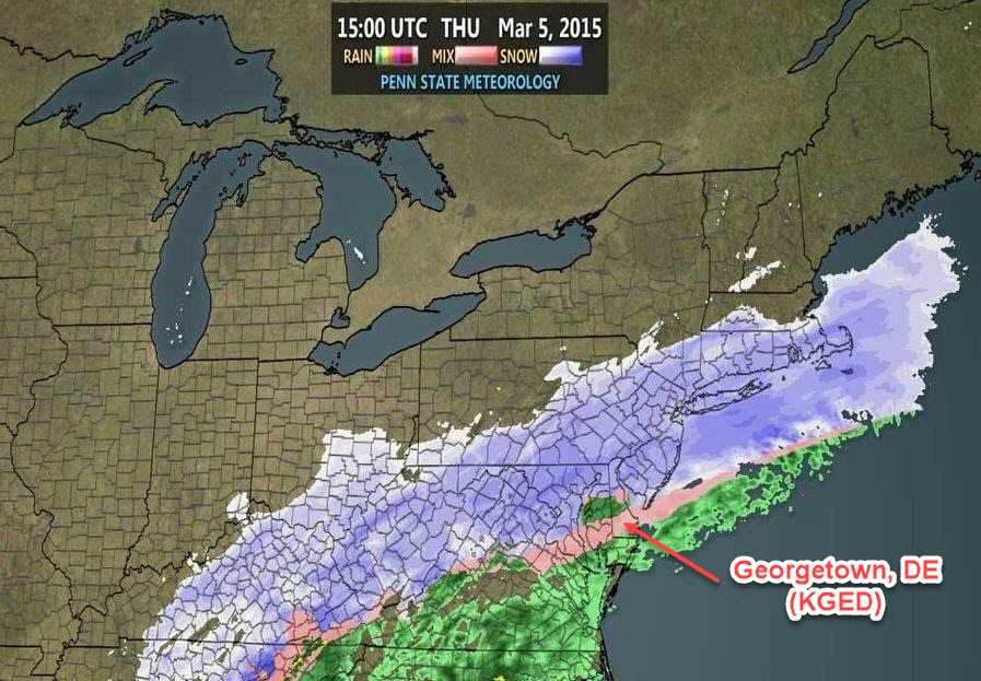
The methods used to formulate this "best guess" for precipitation type aren't perfect, and not surprisingly sometimes the actual observed weather doesn't match the precipitation type shown on the radar image. For example, I've marked Georgetown, Delaware on the map, located within the pink stripe on the radar image, indicating that mixed precipitation was falling. But, the surface observations tell a different story. The Georgetown meteogram shows that light rain was falling at 15Z (the time of the radar image above).
Another common product is a satellite-radar composite, or "sat-rad image" (see image below). For the record, sat-rad images are superimpositions of radar imagery onto satellite images. Before using or interpreting this type of image, make sure that you're aware of a few key things. First, the satellite and radar data come from two completely different sources, even though that might not be obvious from the "look" of the image. As you know, WSR-88D radars are located on the ground (not aboard geostationary satellites), which has some major implications for data coverage.
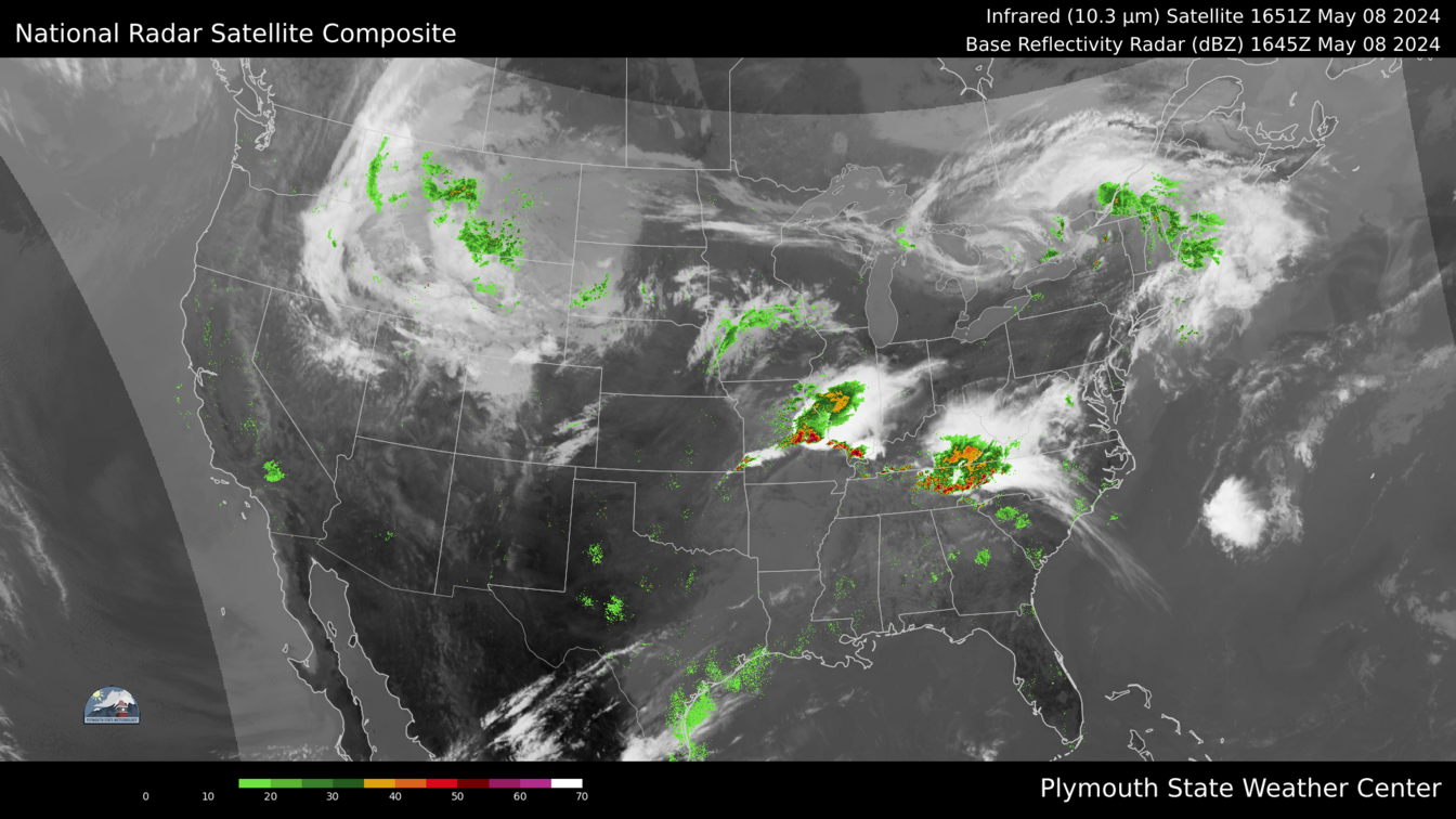
Recall the range of the national array of WSR-88D radars? It does not extend very far out into the oceans nor very far north into Canada nor very far south into Mexico. Thus, to a novice user, sat-rad images can give the impression that some clouds are not producing precipitation when they really are. For example, note the area of clouds an precipitation over New England. According to this radar mosaic, the radar echoes ended very close to the New England Coast. Was it raining farther offshore? We can't tell from this image alone because anything farther away was beyond the range of U.S. radars, but this close-up sat-rad loop of the Northeast shows radar echoes suddenly disapearing offshore at seemingly circular boundaries in some cases -- a clear sign that the radar echoes weren't telling the full story because of the limited range of land-based radar.
These images can really be misleading to someone who's not fully aware of what they show, so make sure to use them with care!