Prioritize...
Upon finishing this page, you should also be able to interpret the "H*Wind" analysis product and identify the various sources of observations that are used to create a particular analysis. You should also be able to identify the Stepped Frequency Microwave Radiometer as an active or passive remote sensor, and explain its capabilities.
Read...
The Air Force Hurricane Hunters don't have the "market cornered" on hurricane hunting. Indeed, the Hurricane Research Division(link is external) (HRD), under the auspice of the Atlantic Oceanographic and Meteorological Laboratory(link is external) (AOML), routinely flies specially equipped aircraft into hurricanes and other tropical weather systems in a concerted effort to advance the scientific understanding of the tropics and, in the process, improve weather forecasts. HRD has a long and storied history(link is external) in the pursuit of excellence in hurricane research.
The NOAA Hurricane-Hunter research fleet (see below), which consists of two WP-3D turboprops (sometimes referred to as "NOAA P-3s") and the Gulfstream IV-SP jet, is under the administrative umbrella of the NOAA's Aircraft Operations Center(link is external).

One of the primary responsibilities of the Gulfstream-IV jet is to deploy dropwindsondes in the environment around and ahead of hurricanes. Often flying at altitudes as high as 45,000 feet, dropwindsondes released by the Gulfstream-IV jet can assess the winds that steer these storms. For example, as Hurricane Isabel approached the East Coast on September 16, 2003, the Gulfstream-IV jet departed MacDill Air Force Base in Florida and proceeded to deploy 23 dropsondes around the hurricane, as this synoptic-surveillance flight plan indicates. If you're interested, you can read more about the capabilities and specifications of this aircraft(link is external) at the Aircraft Operations Center's Web site.
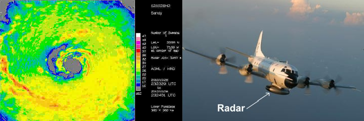
The Gulfstream-IV jet also has two radars (one on the nose, and a Doppler radar on the tail), but the weather instrumentation aboard each NOAA WP-3D actually includes three radars(link is external) (one on the nose, one on the lower fuselage, and a Doppler radar on the tail). In addition to giving insight into the precipitation occurring in the storm, recall from previous courses that Doppler radars have the capability of detecting wind velocities, which helps meteorologists observe the storm's wind field. For example, check out the winds detected by Hurricane-Hunter Doppler radar at an altitude of 500 meters within Hurricane Sandy (in meters per second) at 2351Z on October 28, 2012. The station models plotted on the image represent observations collected by dropwindsondes.

Keep in mind that the range of the ground-based system of radars along the East Coast of the United States (and the Caribbean Islands) is limited and only captures hurricanes that are relatively close to land, making radar images from NOAA P-3's (like the one shown above) indispensable as operational forecasting and research tools. Furthermore, data from these airborne Doppler radars are now being assimilated into the operational forecasting models. In case you want to look at past hurricanes and tropical storms, the Hurricane Research Division provides an archive of their radar data(link is external), but note that radar data is not available for every storm. You can check out more on the capabilities and specifications of the NOAA P-3(link is external), if you would like. And, if you're into history, this very readable paper published in the Bulletin of the American Meteorological Society discusses the history of the aircraft and the roles that they've played in researching tropical cyclones.
H*Wind Analyses
Recall that when tropical storms and hurricanes are active in the Atlantic and eastern Pacific basins, the National Hurricane Center routinely issues Forecast Advisories, which include the maximum radii from a storm's center of 34-knot, 50-knot, and 64-knot winds. As an example, look at this Forecast Advisory for Hurricane Isabel issued at 03Z on September 14, 2003. Take note of the wind radii just below the maximum sustained wind (in bold below):
ZCZC MIATCMAT3 ALL
TTAA00 KNHC DDHHMM
HURRICANE ISABEL FORECAST/ADVISORY NUMBER 32
NWS TPC/NATIONAL HURRICANE CENTER MIAMI FL AL132003
0300Z SUN SEP 14 2003

HURRICANE CENTER LOCATED NEAR 23.0N 63.7W AT 14/0300Z
POSITION ACCURATE WITHIN 15 NM

PRESENT MOVEMENT TOWARD THE WEST-NORTHWEST OR 295 DEGREES AT 10 KT

ESTIMATED MINIMUM CENTRAL PRESSURE 932 MB
EYE DIAMETER 40 NM
MAX SUSTAINED WINDS 140 KT WITH GUSTS TO 170 KT.
64 KT....... 75NE 60SE 60SW 75NW.
50 KT.......100NE 90SE 90SW 100NW.
34 KT.......175NE 175SE 175SW 150NW.
12 FT SEAS..325NE 325SE 275SW 300NW.
WINDS AND SEAS VARY GREATLY IN EACH QUADRANT. RADII IN NAUTICAL
MILES ARE THE LARGEST RADII EXPECTED ANYWHERE IN THAT QUADRANT.
The numbers and letters to the right of each wind threshold indicate the maximum radii from the storm's center in the four compass quadrants. For example, sustained surface winds of 34 knots (minimum tropical-storm strength) extended 175 nautical miles from the center of Hurricane Isabel into the northeast, southeast and southwest quadrants, but the radius of winds with minimum tropical-storm strength extended 150 nautical miles into the northwest quadrant of Isabel.
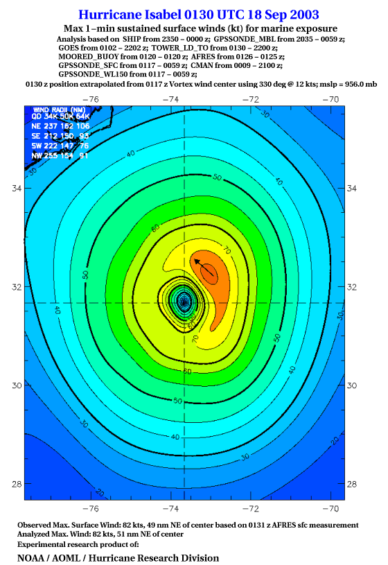
Historically, the wind radii on the Forecast Advisories from the National Hurricane Center were rather subjective because forecasters made their own interpretations of data from reconnaissance aircraft and available surface observations (for example, a forecaster may have multiplied maximum flight-level winds by a subjective value based on his own experience). This subjective approach obviously had drawbacks because it could provide some inconsistent results. However, since 1993, experimental wind fields, called "H*Wind Analyses" (like the one shown below), have helped to bridge the gap between subjective and objective analyses.

While these analyses are not freely available to the public in real-time (more on that in the Explore Further section below), they are used by various public and private agencies involved in risk management and mitigation. How are these analyses created? In a nutshell, data from a potpourri of in-situ and remote sources are collected and then processed to conform to a height of ten meters (about 33 feet), giving forecasters one of the most complete looks at a hurricane's wind field available.
If you peruse the text at the top of the H*Wind analysis of Hurricane Isabel at 0130Z on September 18, 2003 (above), you'll see that wind observations from a ship, a moored buoy, GPS dropwindsondes, GOES-12 (more on estimating winds from satellite later), a C-MAN station, an offshore NAVY tower and Air-Force reconnaissance went into the creation of this analysis. For this "AFRES" observation, maximum flight-level winds were extrapolated to the sea surface. The fact that data from a C-MAN station was included is a hint that Isabel was close to the U.S. coast at this time, as this visible satellite image from around the same time as the H*Wind analysis indicates.
At the bottom of the image of the wind field around Hurricane Isabel, note that the analysis quantifies the maximum observed sustained winds at 0130Z and pinpoints the location of the wind max relative to the center of the storm (82 knots, 49 nautical miles northeast of Isabel's center). This location differs only slightly from objective H*Wind analysis technique (82 knots, 51 nautical miles northeast of the center). By the way, the arrow indicates the direction of the maximum winds.
The Stepped Frequency Microwave Radiometer (SFMR)
Only four days earlier, Hurricane Isabel had packed a much bigger wallop as noted by the maximum wind speed of 125 knots listed below the H*Wind analysis at 0130Z on September 14, 2003. I point this out because, if you look closely, something called an "SFMR" observed the maximum wind speed about 19 nautical miles northeast of Isabel's center. SFMR stands for Stepped Frequency Microwave Radiometer, a passive remote sensor mounted on reconnaissance aircraft (both the NOAA and U.S. Air Force reconnaissance aircraft are equipped with SFMR units).
The SFMR is a powerful tool, and I think it's important for you to have a little background about how it works. The underlying principle that the SFMR employs is that the bulk radiative properties of a substance depend on the "nature" of the substance (size, shape, exposed surface area, etc.). By changing the nature of a substance, its radiative behavior changes, too.
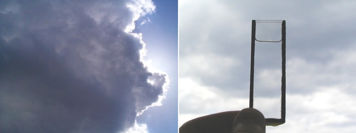
For example, check out the side-by-side images below to see how changing the nature of liquid water can alter the transmission and scattering of visible light. The container on the right is one millimeter thick, so along the path to your eye, visible light has to travel through approximately one millimeter of "bulk water." Most of the visible light is transmitted right through the water, making it transparent. The cumulus congestus shown below on the left, however, is largely composed of tiny water drops about 10 microns in diameter (and there are billions and billions of them). Believe it or not, the total cloud-water content along your line of sight is roughly a measley one millimeter (the same amount as in the container on the right). Yet, the cloud blocks out most of the sunlight because the tiny spherical droplets back-scatter visible light a great deal more than the container of bulk water.

Therefore, when it comes to scattering and transmission, collections of tiny liquid drops cause visible light to behave much differently than it does when encountering the same amount of bulk water. Likewise, the nature of a substance can impact the emission of radiation and changes in emission serve as the basis for the SFMR's ability to detect surface wind speeds. You may not realize it, but the sea emits some natural microwave radiation (everything does, actually), but these emissions from the sea are not very large. In microwave-cooking terms, for example, you couldn't cook anything using the microwave radiation emitted by the ocean, but I assure you that natural microwave emissions from the sea are detectable by airborne radiometers like the SFMR.

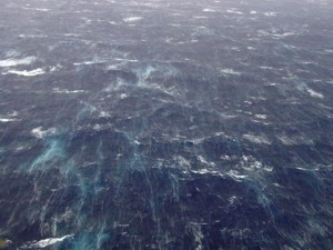
A relatively smooth ocean (winds are relatively light) emits a certain amount of microwave radiation. But, winds blowing over the ocean change the nature of the surface (and thus, its radiative properties). As wind speed increases, patches and streaks of sea foam (essentially, bubbles) start to cover the ocean surface, and it turns out that these patches and streaks of sea foam emit more microwave energy than a smooth, "foamless" sea. The bottom line here is that the SFMR can infer surface wind speeds by detecting increases in microwave emissions from a foamy sea. And, the coverage of sea foam is a function of wind speed (the faster the wind speed, the foamier the sea).
Of course, it's raining to beat the band outside of the eye of a hurricane (particularly in the eyewall), and raindrops certainly would attenuate microwave emissions from the sea (by "attenuate", I mean that raindrops absorb microwave energy from the sea and thus limit the intensity of the energy reaching the SMFR). But the SFMR measures microwave emissions at six different frequencies between 4.6 and 7.2 Gigahertz (hence, the term "stepped frequency"). At any rate, scientists account for the absorption and scattering properties by raindrops at each frequency. By "stepping" through each frequency, scientists can correct for the attenuation of microwave emissions by rain. In the process of correcting for this attenuation, the rainfall-rate can be recovered, yielding bonus data from the SFMR.
For the record, the following SFMR observations are available:
- peak surface wind (in knots) averaged over ten seconds of measurements
- the rain rate (in millimeters per hour) derived over the same ten seconds
- quality-control "flags" that give weather forecasts an indication of the accuracy of these data
As you've already learned, Hurricane Hunters use the SFMR readings for Items H and L of the Vortex Data Message (estimated maximum surface winds inside the tropical cyclone), but the complete set of SFMR observations are transmitted in code. If you're interested in learning more about the complete coded observations and how to translate them in real-time, check out the Explore Further section below. Otherwise, we're ready to move on from the realm of in-situ and remote sensing from aircraft reconnaissance to remote sensing from satellites. After all, over remote seas aircraft reconnaissance is not feasible, so we need to explore some other techniques that forecasters use to remotely observe tropical cyclones. Read on.
Explore Further...
Key Data Resource
If you would like to check out H*Wind analyses for past storms, an archive(link is external) of those produced at HRD through 2013 is available online (archive access requires registration, but it's free). Analyses for current storms are only available for paying subscribers(link is external), but occasionally do become open to the public via social media(link is external).
Decoding Flight-Level and SFMR Observations
SFMR observations are part of the High Density Observations (HDOB) messages from aircraft reconnaissance. HDOB messages represent observations averaged over 30-second intervals along the flight path, and are sent every 30 seconds to two minutes, at the operator's discretion. If you'd like to see the most recent HDOB messages (or search through an archive), check out NHC's aircraft reconnaissance page(link is external). To learn all the details for decoding HDOBs, check out this guide for decoding HDOB messages(link is external). I'll rely on your scientific curiosity to learn the nuts and bolts of HDOBs, but, to get you started, I'll decode one line of an HDOB message from Hurricane Ike(link is external) in September 2008 (underlined in red, below). The data in the last four groupings to the right represent SFMR observations and quality-control "flags" for the entire HDOB (including SFMR data), which I'll address in my last four bullet points (below the HDOB message).
Referring to the table above, here's how to decode the data underlined in red. From left to right, starting with 191930,
- The aircraft took this group of measurements in the 30 seconds after 1919Z
- The aircraft took this group of measurements at Latitude 21 degrees 18 minutes North
- The aircraft took this group of measurements at Longitude 69 degrees 22 minutes West
- Aircraft static pressure: 732.3 mb
- Geopotential height: 2452 meters
- Extrapolated surface pressure: 969.6 mb
- Air temperature: 14.8 degrees Celsius (30-second average)
- Dew point: 14.8 degrees Celsius (30-second average)
- Wind direction and wind speed: 300 degrees at 101 knots (30-second average)
- Peak flight-level wind speed averaged over 10 seconds during the observation period: 104 knots
- Peak surface wind speed (as measured by the Stepped Frequency Microwave Radiometer) averaged over 10 seconds during the observational period: 100 knots.
- SFMR-derived rain rate, in millimeters per hour, measured over the same ten seconds when the peak SMFR surface wind speed occurred: 12 millimeters per hour
- Quality-control flags: 00 (the zeroes indicate that data are reliable; if you see digits other than zeroes in the last group, make sure to assess which data has been specifically flagged using the HDOB decoding guide(link is external)).