Prioritize...
The main purpose of this page is to help you become familiar with the primary forecast products available from professional forecasters at the National Hurricane Center and Central Pacific Hurricane Center so that you can keep tabs on tropical cyclones in the Atlantic, Eastern, and Central Pacific Basins.
Read...
With a wide array of model data available online, it's easy for newer forecasters to get lost in a sea of forecast data. Not to worry, though! Professional tropical forecasters around the globe are constantly watching over the tropics, and issuing forecast products when tropical cyclones form. These products from RSMCs like the National Hurricane Center (NHC) in Miami, Florida, are a great help as you track current tropical cyclones. In addition, they also allow you to virtually shadow professional forecasters to get a sense for how they're thinking about a particular forecast. Indeed, professional forecasters can be an invaluable knowledge resource, even if you don't have "personal connections" to any of them.
In general, tropical forecasters have access to numerous types of observations (some of which you'll learn about later), as well as the same suite of models we've covered. That's a lot of information to manage! The solution? The Automated Tropical Cyclone Forecasting system (ATCF) was developed to streamline the forecasting of tropical cyclones at operational forecasting centers run by the U.S. Department of Defense (like JTWC) and the National Weather Service (like NHC). All of the data are organized in files called "decks" which become the data sources for many graphics used by professional forecasters (many of which are available online). If you're interested in reading more about the various "decks", the Tropical Cyclone Guidance Project provides a brief discussion of these ATCF files in their description of real-time guidance.

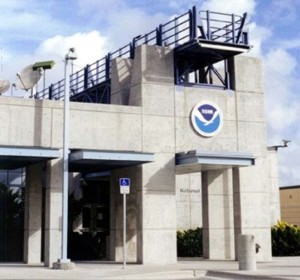
Professional forecasters at NHC process and analyze the available data to develop forecast products in line with their mission statement, which is to "save lives, mitigate property loss, and improve economic efficiency by issuing the best watches, warnings, forecasts, and analyses of hazardous tropical weather, and by increasing understanding of these hazards." From its headquarters on the campus of Florida International University, NHC has responsibilities covering 24 countries in the Americas and the Caribbean Islands, as well as maritime interests in the North Atlantic Ocean, Gulf of Mexico, Caribbean Sea, and Eastern Pacific (north of the Equator).
Even when no active tropical cyclones are present within their jurisdiction during hurricane season (June 1 - November 30 for the Atlantic Basin, May 15 - November 30 for the Eastern Pacific), forecasters at NHC are still watching for areas of potential development, which you can follow with their daily tropical weather discussions (Atlantic Discussion; Eastern Pacific Discussion). However, when a tropical cyclone forms within their jurisdiction, that's when NHC's Web page becomes more active with an abundance of compelling information and images. I won't cover all of NHC's tropical cyclone forecasting products in this section, but I do want to briefly cover the major products so that you know what's available and you can seek professional guidance when tropical cyclones are active in the Atlantic or Eastern Pacific. For the sake of simplicity, I'll separate NHC's products into text products and graphical products. For the record, the same set of products is also available from the Central Pacific Hurricane Center (CPHC) in Honolulu when storms enter their domain.
NHC Text Forecast Products
For a comprehensive overview of all of NHC's text products, you can check out NHC's text products description page. For brevity's sake, I'm only going to highlight and summarize three of the most commonly encountered text products:
- Public Advisories are issued by NHC every six hours (03Z, 09Z, 15Z, 21Z) once a tropical cyclone forms, and are meant to do just what their name implies - advise the public of a tropical cyclone's current status and potential impacts. Check out this sample public advisory for Hurricane Sandy issued at 11 A.M. EDT on October 29, 2012. Note that the critical current facts about the storm (location, maximum sustained winds, central pressure, and current movement) are listed right at the top of the advisory. Following the current status of the storm are sections discussing watches and warnings, a brief outlook, and impacts. When a tropical cyclone threatens land, NHC quickens the pace, issuing public advisories as frequently as every two or three hours depending on the situation.
- Forecast Advisories are a bit more technical than public advisories (see the corresponding forecast advisory for Hurricane Sandy as an example). They're issued by NHC on the same schedule as public advisories, and include much of the same critical information as the public advisories. In addition, forecast advisories also include an estimate for the diameter of the eye in nautical miles, and maximum distances that tropical-storm-force winds (34 knots), storm-force winds (50 knots) and hurricane-force winds (64 knots) extend from the storm's center ("wind radii"). For maritime interests, forecast advisories routinely include distances that waves at least 12-feet high extend from the storm's center ("12-foot wave height radii"). If you need help deciphering a forecast advisory, NHC provides a handy online guide that you can reference (it's very helpful for decoding the forecast information). An added feature of the forecasts beyond 72 hours is that they offer a statement about previous errors in forecasting the storm's track and intensity.
- Forecast Discussions are also issued on the same six-hour schedule as public advisories, and allow you to eavesdrop on how NHC forecasters are thinking about a storm behind the scenes. Given the valuable experience of NHC forecasters, reading forecast discussions can be a tremendous way to learn about forecasting tropical cyclones. Regularly, forecast discussions contain comments on interesting storm features, forecasters' concerns about their current estimate of storm position or strength, model uncertainty and performance, explanations of the decisions forecasters have made, and more. Sometimes, forecasters even liken what they see in certain storms to past storms (an example of "analog forecasting"). The corresponding forecast discussion for Hurricane Sandy shows that forecasters were thinking about Sandy's status as a tropical cyclone as it headed toward landfall (toward the bottom of the discussion).
NHC Graphical Forecast Products
In addition to text forecast products, NHC also issues a number of graphical forecast products, some of which you may already be familiar with because they're so commonly seen on television weathercasts or online. First is NHC's forecast cone of uncertainty. The track forecasts produced by NHC (or any other forecasting outlet, for that matter) aren't perfect, so only providing a single solution would inevitably be fraught with error (check out the average errors for NHC 24, 48, 72, 96, and 120-hour track forecasts). While NHC's track forecasts continue to steadily improve, even three-day forecasts average almost 100 nautical miles of error. Thus, forecast cones of uncertainty, such as the one for Hurricane Irma at 5 A.M. EDT on September 7, 2017 (below), help reflect that the path of the center of the storm is uncertain.

The position of Irma's center at the time the graphic was issued is marked by the black "X." The series of black dots indicate the successive predicted positions of Irma's center (they're just a plot of the coordinates from the forecast advisory). The letters within each dot indicate Irma's predicted intensity at each forecast time ("H" = Hurricane; "M" = Major Hurricane). The white shaded area reflects the cone of uncertainty through Day 3, while the cone for Days 4 and 5 is marked by the white-stippled area. Note how the cone of uncertainty widens with time, reflecting the growing uncertainty as forecast lead time increases.
The width of the cone is based on NHC's historical forecast errors for the previous five years, so the actual width of the cone changes a bit every year. NHC data suggest that the five-day path of a tropical cyclone's center will remain entirely within the five-day forecast cone approximately 60-70% of the time. It should be noted, however, that hurricanes are not "points". They are storms with horizontal breadth. As a result, tropical-storm and hurricane conditions may occur outside the cone, even if the center of the storm remains within the forecast cone of uncertainty. To help make that point, NHC includes a depiction of the current wind extent around the center of the storm (brown and orange shading show the extent of hurricane and tropical-storm force winds, respectively).
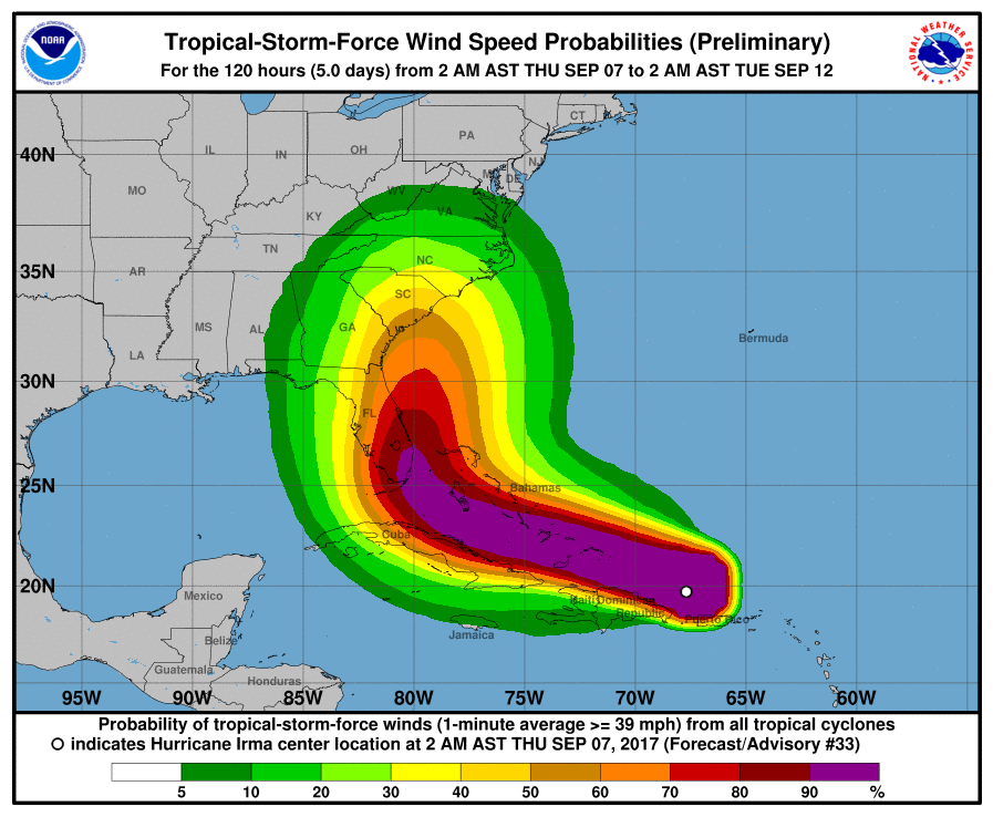
Tropical cyclone intensity forecasts can also be quite uncertain, as suggested by this plot the average error for NHC 24, 48, 72, 96, and 120-hour forecasts. Improvements in intensity forecasting have generally been more modest (suggesting that much work remains to be done toward improving intensity forecasts), and have been most notable for four and five day forecasts. Given the challenges associated with intensity forecasting, NHC produces some probabilistic forecast graphics for tropical cyclone intensity. In an effort to produce products that are simple to comprehend and focus on potential impacts, NHC created graphics showing probabilities of wind speeds reaching or exceeding 34 knots (tropical-storm force), 50 knots (storm force), and 64 knots (hurricane force) within a five day period. The image below represents the probabilities that sustained wind speeds would exceed 34 knots (tropical storm-force) from 2 A.M. (EDT) on September 7 to 2 A.M. (EDT) on September 12, 2017.

Note that sustained tropical-storm force winds were nearly certain across parts of south Florida during this period. Given that Irma was still a far from Florida, however, tropical-storm force winds weren't a sure thing farther north. The probabilities of hurricane force winds in south Florida were lower during this time period (no better than a 50/50 chance in any given location) because of the uncertainties in the storm's future intensity and track, as well as the fact that hurricane-force winds occur over a much smaller area of the storm. If you'd like to see where tropical storm and hurricane-force winds actually ended up occurring from Irma, check out the "Wind History" product in the Explore Further section below.
Of course, timing the arrival of windy conditions with a landfalling tropical cyclone is important, too. For all practical purposes, most preparations need to be completed before tropical-storm force winds arrive in a given location, so NHC also issues products showing the most likely arrival time, as well as the "earliest reasonable" arrival time of tropical-storm force winds ("earliest reasonable" is defined as the time at which there's only a 1 in 10 chance that they'll arrive earlier). For Hurricane Irma, on the morning of Thursday September 7, 2017, NHC predicted that tropical-storm force winds were most likely to arrive in Florida on Saturday evening, but they could arrive as early as Saturday morning.
Other Useful Products
In addition to the forecast products outlined above, I want you to be aware of a few other aspects of NHC's page. First, their site includes links to a wide variety of satellite imagery from across the globe (some making use of techniques we'll cover later), including some "Floater Imagery." These satellite "floaters" provide a "storm-centric" perspective that follows the storm along in time. They're a great way to get a close-up view of a storm as it moves through the tropics.
After each hurricane season ends, NHC also posts a "Tropical Cyclone Report" for each storm in the Atlantic and Eastern Pacific. These reports contain a wealth of information about the storm, including its origins and history, relevant meteorological statistics, casualty and damage statistics, and a discussion / critique of how the storm was handled by forecasters as it happened. NHC even occasionally makes changes to a storm's intensity in their post analysis if they believe that a more thorough analysis revealed that mistakes were made in real time. The final estimates are contained in a table of "Best Track" data in the report.
That wraps up our look at the forecasting products from NHC. This wasn't a thorough treatment by any means, though. For now, I just wanted you to get a feel for the commonly-used products that are available. NHC produces some other products that we'll cover later. In the meantime if you're interested in NHC and its history, or want to see a few other operational products, I encourage you to check out the Explore Further section below.
Explore Further...
Products from other agencies
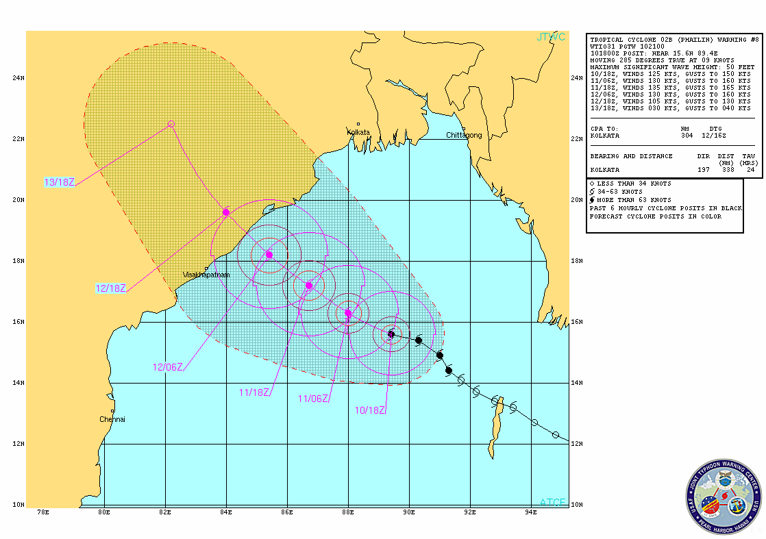
Other forecasting agencies around the globe also produce their own versions of some of the NHC forecasting products you learned about on this page. Each RMSC's products have their own unique features, but you can usually find their equivalents to public advisories, forecast discussions, and forecast cones of uncertainty. The Joint Typhoon Warning Center, for example, issues forecast cones of uncertainty that look like the one below for Severe Cyclonic Storm Phailin from 18Z on October 10, 2013.

This cone looks a bit different from those issued by NHC, and indeed, there are some differences in interpretation. The black tropical storm and typhoon symbols represent prevous storm positions, while the pink symbols represent official forecast positions. The concentric rings around the official forecast positions represent the predicted radii for 34-knot, 50-knot, and 64-knot winds. Meanwhile, the hatched area of uncertainty is defined by the 34-knot wind radius plus JTWC's historical forecast error. On the right of the image is a listing of the storm's current location and motion, as well as forecast positions and intensities. If you would like to know more about these graphics, you can check out the complete guide. JTWC also issues "prognostic reasoning" discussions twice a day for active storms (their version of a "forecast discussion"), which give you deeper insights into what's going on with each storm and why forecasters settled on specific forecast details. JTWC produces other advisories, alerts, and warnings, too. If you'd like to learn more and see the issuance schedule, check out JTWC's product guide.
NHC's "Wind History" Product
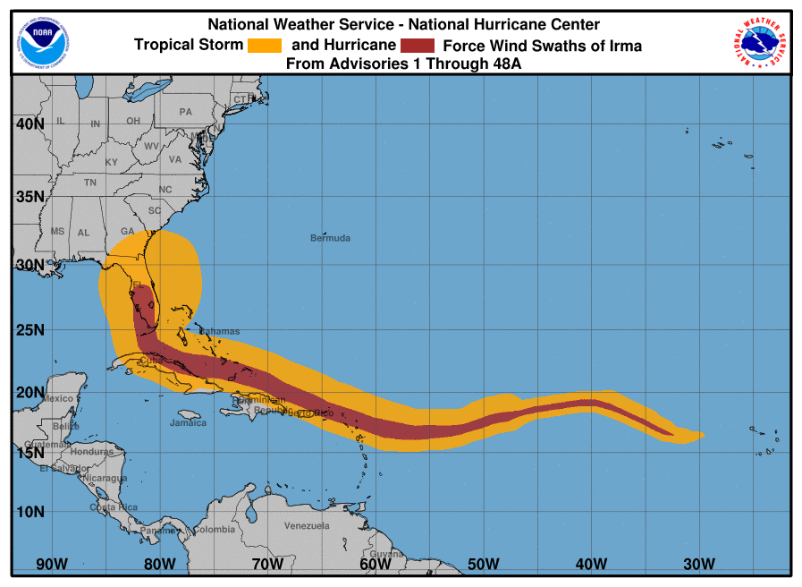
If you quickly glance at the image below, it might remind you of a forecast cone of uncertainty, but it's not a forecast at all! Actually, it's a history that documents the winds during the life of Hurricane Irma in 2017 (based on wind radii from official advisories issued by NHC). In this case, the cumulative winds span from the time NHC christened Irma as a tropical storm until NHC downgraded the storm after landfall. For an ongoing tropical cyclone, these graphics of cumulative winds will display tropical storm- and / or hurricane-force winds (in orange and red, respectively) right up to, and including, the most recent NHC advisory. By the way, if this specific product reminds you of a "cone", please keep in mind that the map background is a Mercator projection, so there's the standard distortion at higher latitudes (areas of tropical storm- and hurricane-force winds naturally appear larger with increasing latitude, even though the size of storm may not be increasing).

For History Buffs
The National Hurricane Center is co-located with the National Weather Service-Miami / South Florida forecast office, which has a long and storied history that you may enjoy reading. Today, NHC is comprised of several units, including the Tropical Analysis and Forecasting Branch (TAFB), and the Technology and Science Branch (TSB). That's right, NHC's responsibilities aren't just limited to operational forecasting when tropical cyclones threaten! To find out more, check out the overview of NHC's structure.