Prioritize...
Upon completion of this section, you should be able to identify the basins across the globe that typically produce tropical cyclones and interpret the meaning of tropical cyclone classifications (such as tropical depression, tropical storm, etc.). Although you will not be specifically tested on the various naming conventions used in basins around the world, you should leave this page with a basic idea of the various naming schemes because it will give you context for the various case studies that we will discuss throughout the course, and help you track tropical cyclones globally.
Read...
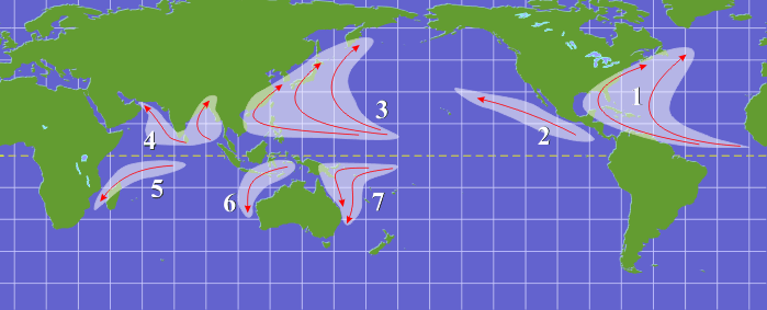
Up to this point, you've seen the generic phrase "tropical cyclone" used to describe the low-pressure systems that form over warm tropical seas. However, as you're about to find out, naming and classifying tropical cyclones is somewhat complicated. Before we get into how tropical cyclones are named, let's look at the areas where tropical cyclones tend to form. Do they form just anywhere in the tropics? Not really. As you can see from the image below, the breeding grounds and regions where tropical cyclones typically track can be boiled down to seven areas:
- Atlantic Basin (the northern Atlantic Ocean, the Gulf of Mexico, and the Caribbean Sea)
- Northeast Pacific Basin (from Mexico to the International Dateline)
- Northwest Pacific Basin (from the International Dateline to Asia, including the South China Sea)
- North Indian Basin (includes the Bay of Bengal and the Arabian Sea)
- Southwest Indian Basin (from Africa to about 100 degrees east longitude)
- Southeast Indian/Australian Basin (100 degrees east longitude to 142 degrees east longitude)
- Australian/Southwest Pacific Basin (142 degrees longitude to about 120 degrees west longitude

Of these seven areas, the Northwest Pacific and Northeast Pacific basins tend to be the busiest, as this frequency plot for tropical cyclones suggests. It shows the average number of occurrences (from 1972 to 2001) that the center of a tropical cyclone occupied an area with dimensions of one degree latitude by one degree longitude (based on each storm's best track). The dark red color indicates the highest average of such occurrences and thus marks the core of these breeding basins for tropical cyclones. Meanwhile, some areas in the tropics are nearly entirely free of tropical cyclones. While tropical cyclones can form outside of the seven areas listed above, it happens relatively infrequently. For example, the southern Atlantic Ocean (south of the equator) is rarely home to tropical cyclones.
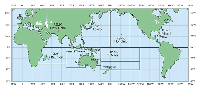
With tropical cyclones in any basin possibly impacting multiple countries, how do forecasters keep tabs on all of them? The World Meteorology Organization created a branch called the Tropical Cyclone Programme (TCP) to ensure that all countries bordering and within each basin are adequately prepared for the threat posed by tropical cyclones. To accomplish this goal, the TCP's primary responsibility is to establish a nationally and regionally coordinated network of forecasting centers. To define areas of responsibility, they partitioned the tropical-cyclone basins and assigned Regional Climate Centers (RCCs), which issue the official forecasts and advisories for their respective basins (see figure below). If you wish, you can check out the WMO Web Page that lists the links to the Tropical Cyclone RCCs where you can access all the current RCC advisories.
Although each RCC is responsible for issuing the official forecasts and advisories for their jurisdiction, there can be multiple cities which issue warnings for various countries under the umbrella of a single RCC. For example, the official advisories and forecasts for the Atlantic Basin come from: the National Hurricane Center in Miami, but the Canadian Hurricane Centre in Dartmouth, Nova Scotia issues warnings when tropical cyclones threaten Canada, using the National Hurricane Center's products as their basis. Keep in mind that Atlantic hurricanes and tropical storms moving northward along the East Coast can pose a significant threat to the Canadian Maritimes (the provinces of New Foundland, Nova Scotia, New Brunswick, and Prince Edward Island).

In addition to the Regional Specialized Meteorological Centers and Tropical Cyclone Warning Centers on the map above, the Joint Typhoon Warning Center (JTWC) is an additional warning center and serves as a joint effort between the United States Navy and Air Force. JTWC was founded in 1959 in Guam, but has since moved to Pearl Harbor, Hawaii. While JTWC does not issue official public forecasts, they keep tabs on tropical cyclones globally for U.S. Department of Defense interests.
Now that we know who's keeping track of tropical cyclones around the globe, we can delve into how they keep track of them. That's where things can get a bit complicated because standards differ across the globe. For starters, forecasters often have their eyes on clusters of showers and thunderstorms across the tropics (often called "tropical disturbances"). Tropical disturbances do not have closed circulations and are not formally tropical cyclones; however, by convention in the U.S., tropical disturbances that have the potential to develop into tropical cyclones are dubbed "invests." Each invest is tagged with a number from 90-99 along with a capital letter, which corresponds to the tropical basin where it's located (see the table below for the letters that correspond to each basin). Forecasters start with the number 90 and sequentially progress to 99, and then start over again at 90. So, for example, Invest 99L in the Atlantic Basin would be followed by Invest 90L, and so on.
If the tropical disturbance with organized convection develops a closed cyclonic circulation in its surface wind field, it becomes a tropical depression as long as its maximum sustained wind speeds are less than 34 knots (39 miles per hour). Note that different definitions of "sustained" (as described in the link) can lead to different storm classifications in different basins. Tropical depressions are formally considered tropical cyclones, and at this point The Joint Typhoon Warning Center, Central Pacific Hurricane Center, and the National Hurricane Center routinely assign a new number to go along with the letter referring to the basin of origin. For each season in each basin, the digits start at "01" and then increase by one for each successive depression that forms. Since the capital letter refers to the basin of origin, the letters are not changed if tropical cyclones cross 140 or 180 degrees longitude. I should note, however, that depressions in the Atlantic Basin are an exception. When a depression is classified in the Atlantic, the National Hurricane Center simply refers to it by its number ("One", "Two", etc.) and the letter "L" gets dropped from the designation.
| Letter | Basin |
|---|---|
| L | North Atlantic |
| W | Western North Pacific (west of 180°) |
| C | Central North Pacific (140 to 180°W) |
| E | Eastern North Pacific (east of 140°W) |
| A | Arabian Sea |
| B | Bay of Bengal |
| S | South Indian Ocean (west of 135°E) |
| P | South Pacific Ocean (east of 135°E) |
Once a tropical cyclone reaches sustained wind speeds of at least 34 knots (39 miles per hour), it becomes a tropical storm and receives a name (more on the naming of tropical cyclones in a bit). Tropical cyclones retain their tropical storm status as long as their maximum sustained winds remain between 34 knots and 63 knots. Once a tropical cyclone reaches maximum sustained winds of at least 64 knots (74 miles per hour), it loses its "tropical storm" label, and earns the classification of hurricane, typhoon, severe cyclonic storm, tropical cyclone or severe tropical cyclone, depending on the basin in which the storm is located (see the table below for what words are used in each basin. At times, I may generically refer to "hurricanes" in the text, but keep in mind that such references also include strong tropical cyclones that go by various labels in basins around the world.
| Word | Basin(s) |
|---|---|
| Hurricane | Atlantic, Northeast Pacific, South Pacific (east of 160ºE) |
| Typhoon | Northwest Pacific |
| Tropical Cyclone | Southwest Indian (west of 90ºE) |
| Severe Tropical Cyclone | Southeast Indian (east of 90ºE) |
| Severe Cyclonic Storm | North Indian |
Of course, all "strong" tropical cyclones (hurricanes, typhoons, etc.) are not created equal. Some are much more intense than others. In the Atlantic and Northeast Pacific basins, forecasters use the Saffir-Simpson Hurricane Wind Scale to further classify a given hurricane. Hurricanes classified as "Cat 3", "Cat 4" or "Cat 5" (all hurricanes with maximum sustained winds of at least 96 knots, or 111 mph) qualify as major hurricanes. Although major hurricanes make-up only 21% of the hurricanes that hit the United States, these fierce storms account for over 83% of all the damage from landfalling hurricanes. For the record, Australian forecasters, rank tropical cyclones a bit differently.
Other basins also have different descriptors for extremely intense tropical cyclones. In the Northwest Pacific Basin, for example, the particularly descriptive classification of "super typhoon" is used once a typhoon's maximum sustained wind speed reaches at least 130 knots (more than twice the minimum typhoon wind speed). For some interesting tidbits on some memorable super typhoons, check out the Explore Further section below. In the North Indian Ocean, meanwhile, severe tropical cyclones that attain maximum sustained winds of at least 130 knots graduate to super cyclonic storm.
The Name Game
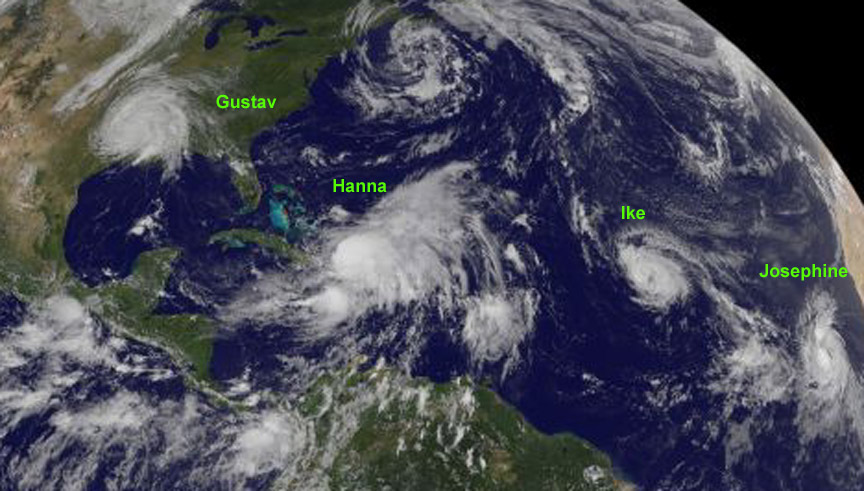
There's a checkerboard history behind the naming of tropical cyclones in the various basins around the world. If you're interested in the history of naming tropical cyclones, I encourage you to check out the corresponding section within Explore Further below. The reason why tropical cyclones get named, however, is pretty straightforward. The practice of naming tropical cyclones ensures clear, unambiguous communication between forecasters and the general public when forecasts, watches, and warnings are issued. At any given time across the globe (or even within a single tropical basin) there can be multiple tropical cyclones present at any one time. For example, the satellite image from September 2, 2008 (below) shows a whopping four named storms present in the Atlantic Basin!

Without the practice of naming tropical storms, deciphering forecasts with four active storms in the basin could have been a real mess -- sifting through coordinates or other technical descriptions of a storm's location. In the end, using names is much simpler for the general public, so let's get to the (not so simple) business of how storms are named. In the Atlantic and eastern Pacific, the World Meteorological Organization and National Weather Service (NWS) have used lists of alternating male and female names in alphabetical order to christen storms since 1979 (check out the lists currently in use if you wish).
I should point out that any year that the alphabetical list of male and female names is not long enough to accommodate all the named storms in a season, the National Hurricane Center turns to a supplemental list of names; however, prior to 2021, the standard was to use letters of the Greek Alphabet (Alpha, Beta, Gamma, Delta, etc.) to name storms once the original list of names had been exhausted. Use of the Greek Alphabet to name storms only occurred twice (2005 and 2020).
For Central Pacific storms, the Central Pacific Hurricane Center uses its own list of names of Hawaiian origin. Because not many tropical cyclones form in the Central Pacific, they don't restart the list from the beginning each year, and instead they just keep using the same list until all the names have been used. When they reach the end of one list, they simply begin with the first name on the next list.
Meanwhile, in the northwest Pacific Basin, since the year 2000, the World Meteorological Organization has used names which are, for the most part, not male or female names. Instead, most names on the list refer to flowers, animals, birds, trees, or even foods, etc. Others are simply descriptive adjectives. Each name on the list is contributed by a participating nation within the basin. The names are not used in alphabetical order like in the Atlantic and eastern Pacific, however. Instead, the contributing nations are listed in alphabetical order and this ranking determines the order that the names are assigned.
It's important to note, however, that the established lists from the World Meteorological Organization are not universally used for storms in the northwest Pacific. The Philippine Atmospheric, Geophysical and Astronomical Services Administration (PAGASA) assigns Filipino words as storm names when storms threaten the Philippines so that locals can easily remember them and communicate about the storm. For example, in November 2013 Super Typhoon Haiyan made landfall in the Philippines as one of the strongest tropical cyclones on record at the time of landfall. But, in the Philippines, Haiyan (which is from the Chinese for "petrel" -- a type of seabird) was known as "Yolanda." So, be aware that you may come across two names for some storms in the northwest Pacific Basin.
Finally, in the North Indian Ocean, tropical cyclones weren't named from a traditional list until 2004. Prior to that year, conventions for identifying storms and keeping historical records were somewhat awkward (more in Explore Further). With regard to name selection, eight countries belonging to the WMO Tropical Cyclone panel for the North Indian basin contributed eight names each, which were tabulated into eight columns. In each column, one name from each country appeared, with the names listed in the order determined by the alphabetized contributing nations (the same convention as in the Northwest Pacific basin). You can see the lists of names for tropical cyclones in the North Indian Ocean and all other tropical basins (including basins not covered in-depth here) on the World Meteorological Organization's page of tropical cyclone names.
An average of approximately 80 strong tropical cyclones form each year worldwide -- a small number compared to the hundreds and hundreds of cyclones that parade across the middle and high latitudes each year. Yet, the attention that meteorologists focus on tropical cyclones sometimes seems disproportionately great. That's because strong tropical cyclones can cause staggering losses of life and property. Next up, we'll compare tropical cyclones with mid-latitude cyclones. Not surprisingly, there's a world of difference between them!
Explore Further...
Some Memorable Super Typhoons
The northwest Pacific basin is home to some of the most impressive tropical cyclones in the entire world, and the term used to classify extremely strong tropical cyclones in the basin -- "super typhoon" is very appropriate. In November 2013, Super Typhoon Haiyan made landfall in the Philippines with estimated maximum sustained winds of 195 miles per hour and an estimated central pressure of 895 millibars. Even though Haiyan may have been the most intense tropical cyclone on record at landfall, it's not the most intense tropical cyclone in recorded history (in terms of lowest sea-level pressures, anyway). That honor goes to Super Typhoon Tip (1979). The lowest sea-level pressure ever recorded on Earth occurred in Super Typhoon Tip -- 870 millibars. Tip spent 48 consecutive hours as a super typhoon, which was a record at the time. That record, however, has since been smashed by two super typhoons that occurred simultaneously!
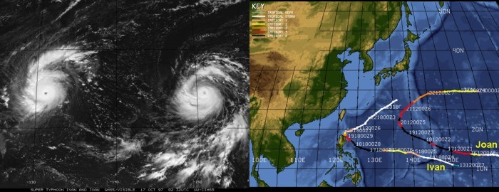
In 1997, there were two super typhoons in the northwest Pacific basin at the same time, Ivan and Joan (see image below). Ivan's maximum sustained winds reached approximately 160 miles per hour on October 18, 1997, and Joan's top winds approached 180 miles per hour (also on the 18th). Both Joan and Ivan smashed Tip's endurance record as a super typhoon, with Joan lasting more than 100 consecutive hours as a super typhoon and Ivan completing more than 60 straight hours as a super typhoon. In modern times, there have never been two simultaneous super typhoons with such great, sustained intensity.

For History Buffs
Above, I summarized the current methods for naming tropical cyclones in most of the major tropical basins, but conventions have changed over the years. Indeed, each basin has its own unique history of naming tropical cyclones. In the Atlantic, the earliest practice of naming Atlantic hurricanes goes back a few hundred years to the West Indies. Indeed, islanders named hurricanes after saints (when hurricanes arrived on a saint's day, locals christened the storm with the name of that saint). For example, fierce Hurricane Santa Ana struck Puerto Rico on July 26, 1825, and Hurricane San Felipe (the first) and Hurricane San Felipe (the second) hit Puerto Rico on September 13, 1876 and September 13, 1928, respectively.
During World War II, US Army Air Corps forecasters informally named Pacific storms after their girlfriends or wives (who probably wouldn't have been happy if they had known). That apparently started the ball rolling in the United States. From 1950 to 1952, meteorologists named tropical cyclones in the North Atlantic Ocean according to the phonetic alphabet (Able, Baker, Charlie, etc.). Then, in 1953, the U.S. Weather Bureau switched the list to female names. In 1979, the World Meteorological Organization and the National Weather Service (NWS) amended their lists to also include male names.
Elsewhere around the globe, an Australian forecaster named Clement Wragge began to name tropical cyclones after politicians he disliked just before the start of the nineteenth century. Forecasters in the Australian and South Pacific regions (east of longitude 90 degrees East, and south of the equator) formally started to christen tropical storms with female names in 1964. They beat the United States to the punch and began to use both male and female names in the mid 1970's.
Prior to the current convention in the northwest Pacific, JTWC forecasters started to use female names for tropical cyclones in 1945. In tandem with the 1979 change in the United States, forecasters amended their lists to include male names, but they abandoned that practice on January 1, 2000 when they switched to the current convention of using words that are typically not male or female names.
Finally, above I mentioned that conventions for naming storms and keeping historical records were somewhat awkward in the North Indian basin before 2004. Before storms were named from a list, in real-time, forecasters simply used the two-digit / letter label that the cyclone received once it attained tropical-depression strength (for example, "Tropical Cyclone 02A" for the second tropical cyclone of the year in the Arabian Sea). Keeping historical records got a bit complicated because forecasters used an identification code composed of an Arabian Sea / Bay of Bengal indicator, the last two digits of the year and a two-digit number that designated the order of occurrence of the storm during that year. For example, a storm with the coded ID, BOB 9903, was the third tropical cyclone of 1999, and it formed in the Bay of Bengal (BOB). Records now include the name of the storm, but most storm reports you'll see from this basin will reflect past and present conventions. For example, the very first storm named from a list in the basin was "Onil" on October 1, 2004. It was frequently referred to in statements as "Tropical Cyclone Onil (03A)".