Prioritize...
When you've finished this page, you should be able to discuss the difference between the Lagrangian time scale and the duration of a weather feature. You should also be able to apply your knowledge of mid-latitude weather features from previous courses to compare their time scales and durations. Finally, you should be able to make generalizations connecting the size scale of a feature to its duration.
Read...
Now that you have a good handle on where the mesoscale fits into the range of spatial scales, it's time to shift gears and talk about time scales. To launch our discussion, let's cover a couple of definitions:
- The Lagrangian time scale (or "time scale" for short) of a weather system, is the amount of time it takes for an air parcel to move through the entire system. The word, "Lagrangian," means that we follow an air parcel on its trek through the weather system.
- The duration of a weather system refers to its lifetime -- how long the feature itself lasts.
To understand the difference between the time scale of a weather system and its duration, I'll use a supercell thunderstorm as an example. Recall that supercell thunderstorms possess a persistent, rotating updraft that sometimes (although not always) produces a tornado. The duration of most supercells is, as a general rule, between one and four hours, which means that most supercells "live" for one to four hours, before they dissipate. I should note, however, that long-lived supercells can last as long as eight hours.
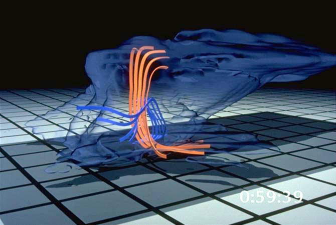
Now, what about the time scale of a typical supercell? For starters, check out this nifty computer simulation of a tornadic supercell showing the motions of various streams of air that flow through the storm. It's clear from the animation that individual air parcels flow all the way through a supercell during its lifetime. The peach-colored ribbons indicate the paths that air parcels took through the updraft of an idealized supercell. Relative to the moving storm, air parcels enter the storm near the ground, rise, and then get whisked downstream by westerly winds near the top of the storm. The trip through the updraft usually lasts about 20 minutes, which serves as a fairly good approximation for the Lagrangian time scale of a supercell. In case you're wondering, the blue ribbons follow the paths of air parcels entering the rear of the storm and ultimately sinking toward the ground.

The bottom line here is that the time scale of a weather feature might be a lot different from its duration. Think back to some mid-latitude weather features that you studied previously. A jet streak, for example, moves along in the flow at 300 mb at 30 to 50 knots, on average, during the winter. But, individual air parcels are moving much faster, and they accelerate right through the jet streak. In other words, a jet streak's duration is much longer than its Lagrangian time scale.
We can apply similar thoughts to shortwave troughs. The troughs themselves move along in the synoptic-scale flow, but individual air parcels move right through the shortwave (causing divergence downstream, if you recall). So, because the shortwave lasts much longer than the amount of time it takes for a parcel to travel through it, the duration of a shortwave trough is longer than its Lagrangian time scale.
Most of the references that you'll run across will typically categorize weather systems by their spatial scales and their duration (not their Lagrangian time scales). But, I like to make a clear distinction here because we'll talk a lot this semester about how air parcels move relative to the parent weather systems.
Still, there's a general relationship between the size scale of a weather feature and its duration. The duration of a dust devil (photograph courtesy of David DiBiase), a microscale rapidly rotating wind that is made visible by the dust, dirt or debris it picks up, is typically on the order of a few minutes or shorter. Under optimum conditions, dust devils can last as long as a few tens of minutes, but such "long-lived" dust devils are rare. On the other hand, keeping in mind that the duration of a supercell thunderstorm (a meso-γ or meso-β feature) is typically one to four hours, you should now get the impression that, as the spatial scales of weather features decrease, so do their duration.
To confirm your impression, check out the schematic below; it displays the spatial scales (horizontal axis) and duration (vertical axis) of selected weather features. Pay close attention to relationship between spatial scale and duration. As a general rule (with a few exceptions), the smaller the spatial scale, the shorter the duration.

Given the relatively short duration and small spatial scale of mesoscale phenomena, forecasters require computer models that are higher resolution and incorporate hourly observations so as to more accurately model rapidly evolving weather patterns. We'll investigate in the next section.