Motivate...
In the previous lesson, we covered many tools that mesoscale forecasters have at their disposal, but I saved the discussion of perhaps the most important tool -- an understanding of the big-picture weather pattern -- for its own lesson. Indeed, mesoscale forecasters must first study the big picture at the surface and aloft in order to make sound forecasts for mesoscale weather. In this lesson, we'll build on the fundamental concepts you learned in your previous studies so that you can better assess the synoptic-scale weather pattern and its potential impact on mesoscale weather.
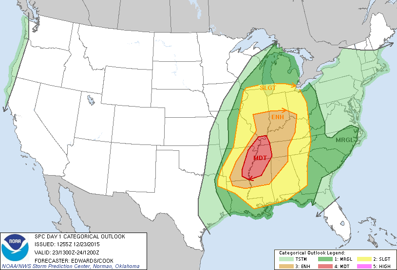
For any outbreak of severe weather, it's the primary responsibility of the Storm Prediction Center to alert local forecasters and officials. Long before issuing individual severe-thunderstorm or tornado watch boxes, SPC regularly issues "Convective Outlooks" that highlight areas where thunderstorms and severe weather may pose risks. For example, take a look at the Day 1 Convective Outlook issued at 13Z on December 23, 2015, which covers the time period from 13Z on December 23, through 12Z on December 24.

For the period from 13Z on December 23 through 12Z on December 24, the forecasters at SPC had highlighted portions of the Lower Mississippi Valley as having a "moderate" risk for severe weather (a four on a scale from one to five). Surrounding this region of "moderate" risk were areas of "enhanced" risk, slight risk and "marginal" risk. What do these categories mean? For the formal definitions, I suggest you go straight to the source -- SPC's convective outlook descriptions, for a better understanding of the risk categories (marginal, slight, enhanced, moderate, and high). For the record, these outlooks also outline regions having at least a 10 percent chance of "non-severe" thunderstorms.
The SPC Day 1 Convective Outlook is issued several times a day. In addition to these "categorical" outlooks, SPC also issues probabilistic outlooks for large hail, damaging winds, and tornadoes (here are the outlooks for large hail, damaging winds, and tornadoes from December 23, 2015).
SPC's forecast for December 23 was very good, as you can tell from this overlay of severe weather reports on the 13Z Day 1 Convective Outlook. How were forecasters at SPC able to highlight areas where severe weather would likely occur hours or days before thunderstorms actually formed? In this particular case, SPC began highlighting December 23 as a day with possible severe weather as early as December 20 (check out the Day 4 Convective outlook from December 20). The answer to this question is simple: forecasters thoroughly analyzed the "big picture" (synoptic-scale weather pattern) in order to identify areas where severe thunderstorms could be favored.
For a better understanding of what I mean, consider the fact that each convective outlook comes with a discussion that elaborates on the scientific rationale for predicting severe thunderstorms (here's the discussion for December 23, 2015). While some of the discussion may be undecipherable to you right now, notice that most of the content of this discussion focuses on the synoptic-scale weather pattern. Indeed, the discussion references a long-wave trough, shortwave trough, surface low-pressure system, a cold front, a stationary front, and a warm front. Those are all features you learned about in your previous studies! Tracking these features, along with an understanding of how they can impact mesoscale weather, were the keys to a successful convective outlook.
The discussion also mentions vertical wind shear and something called "CAPE," which we really haven't discussed in detail yet. These are key variables for mesoscale forecasters, and we'll tackle them early in this lesson so that you can understand how they're tied to the synoptic-scale weather pattern. From there, we'll take a tour of the troposphere (from the surface to 300 mb), reviewing some key materials from your previous studies, and discussing how weather features throughout the troposphere impact forecasts for thunderstorms.
The bottom line for Lesson 3 is that you can't become a good mesoscale forecaster until you know how to competently assess the big picture and to use the background synoptic-scale pattern to identify regions at risk for severe thunderstorms. Let's get started!