Glacier National Park
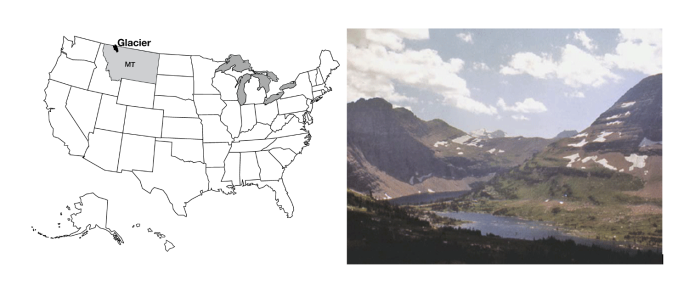
Glacier National Park is the southern part of the Glacier-Waterton Lakes International Peace Park, extending north-south across the Canadian-U.S. border and east-west across the great Front Range of the Rockies. Glacier is home to wolves and grizzly bears, mountain goats balanced on cliffs, moose munching on water plants, and beautiful flowers such as beargrass and avalanche lilies. Going-to-the-Sun Road winds past Going-to-the-Sun Mountain, among the best-named features of the park system. The Garden Wall is a knife-edge ridge left as glaciers gnawed into the backbone of the continent from the east and the west, and in many places is the continental divide. Long, narrow lakes lie along the valleys, which sometimes host lines of lakes strung like beads on the string of the connecting river. (Such glacier-carved strings of lakes are called paternoster lakes, after a resemblance to the beads of a Catholic rosary.)
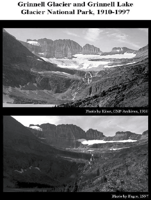
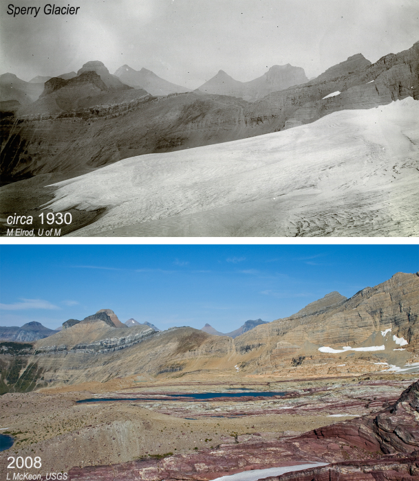
Glacier National Park had roughly 80 active glaciers in 1850, dropping to perhaps 25 in 2022. There is a little uncertainty related to exactly how big and active a mass of ice must be, to be called a glacier. Many of the former glaciers may be essentially dead now, as human-caused warming melts many away (see the changes shown by the older and more recent photos below; again, we will come back later to how we know that the changes are human-caused). Glacier National Park is now more noted for the tracks of past glaciers than for the activity of present ones. But, we suspect that “Ex-Glacier National Park” would not have made the Great Northern Railway happy when they were promoting tourism in Glacier National Park (via the Great Northern Railway, of course). When the last glacier has melted away, perhaps within a few decades, there are no plans to change the park's name.
Evidence of Ice Ages
Today, permanent ice covers about one-tenth of the land on Earth, mostly in Antarctica and Greenland, with a little ice in mountainous regions. We saw at Yosemite that glacier erosion and deposition produce features that differ from those produced by mass movement, rivers, wind, or coasts. Geologically recent examples of those features, produced by glaciers, from roughly 20,000 years ago, are spread across almost one-third of the modern land surface—in places such as Wisconsin, northern Pennsylvania, Yosemite, and Glacier National Parks, and many others, the mark of the ice is unmistakable. The 10,000 lakes of Minnesota, the Great Lakes, the gentle moraines of Illinois, and many more features reveal a glacially-dominated landscape. Such features in Europe first motivated the hypothesis that ice ages have occurred.
This ice-age hypothesis makes many predictions, which allow testing. In times before modern geology, the glacial deposits were called “drift” because they were thought to have drifted into place in icebergs during Noah’s flood. Other people have suggested that the deposits were splashed into position by a giant meteorite that hit Hudson Bay, and other hypotheses have been advanced. But, the ice-age hypothesis makes predictions that differ from the Noah’s-flood hypothesis or the meteorite hypothesis in many ways, and the ice-age predictions are confirmed beautifully, while the others failed. (The biggest difference is that icebergs and meteorites do not make features that even vaguely resemble those actually observed, but let’s look at other differences.)
If huge ice existed, its great weight must have pushed down the land beneath—recall that the deep rocks are hot and soft, with a “water-bed” cover of stiffer rocks on top. If the ice age peaked only about 20,000 years ago, the slow flow of the soft, deep rocks should mean that the land where the ice once sat would still be rising after the melting, while the land around the former ice would be sinking as the soft, deep rocks return to their pre-ice-age positions. The global flood hypothesis and the meteorite hypothesis do not predict such a bulls-eye pattern of rising and sinking centered on the regions with features known to be made by glaciers today—the flood would have spread evenly across the land, and would not have concentrated its weight in one place. The sudden blast of the meteorite would not have left its weight long enough to push the slow-flowing deep rocks far. Measurements by GPS and other techniques show just the pattern expected from the ice-age hypothesis, a pattern not predicted and not explained by the other hypotheses. (We will show you some of the evidence for this, and for the flooded river valleys described just below, when we visit Acadia in our discussion of coasts in Module 8.)
The water for huge ice sheets would have been supplied by ocean evaporation, with the water getting stuck in the ice rather than returning rapidly to the sea in streams. Hence, if ice ages occurred recently, there should be evidence of lower sea levels when the ice was big. No such prediction comes from the meteorite or big-flood hypotheses (the meteorite might have made a wave but otherwise would not have affected sea level; the big flood would have raised sea level). Again, the ice-age prediction is borne out by the evidence, and the predictions of the other hypotheses are wrong. For example, some corals grow only in shallow waters with much sunlight. Dead samples of such corals from about 20,000 years ago can be found where they grew, down the sides of islands and now under more than 300 feet of ocean water. Other evidence also points to lower sea level in the recent past—geologic evidence shows that the Chesapeake Bay, for example, is a river valley drowned by rising ocean waters.