Prioritize...
After completing this section, you should be able to discuss the local, regional, and global effects (via teleconnections) of El Niño and La Niña, including changes to the Walker Circulation and patterns of precipitation over the equatorial Pacific, and changes to the subtropical jet stream. However, you need not memorize specific global teleconnections for any particular season or area.
Read...
Even though a seemingly slight warming or cooling of water temperatures in the equatorial Pacific might not seem like a big deal, the impacts of El Niño and La Niña can be dramatic on a global scale. To summarize the impacts of El Niño and La Niña, I'm going to start with local impacts and we'll work our way up through regional impacts and global impacts. In many ways, since El Niño and La Niña are opposites, their impacts are opposite, but that's not always the case!
Local Impacts
I'll start with a direct, local impact of the warmer waters of El Niño. El Niño negatively impacts the living organisms within the marine ecosystem in the eastern equatorial Pacific. Under normal conditions, the nitracline, an underwater boundary that separates cold, deep water with relatively high concentrations of nitrates from shallower water with lower concentrations, lies at a relatively shallow depth. For the record, nitrates serve as nutrients that plants, such as phytoplankton(link is external) (the base of the ocean's food chain), require for photosynthesis and growth.
With a shallow nitracline, nutrient-rich waters are often brought to the sea surface off the west coast of South America, where they fertilize blooms of phytoplankton that sustain a bounty of fishes. In turn, fish serve as the base of the food chain for seabirds and higher-order mammals that populate the rich and diverse ecosystem in the Galapagos Islands. But, with the onset of El Niño, the nitracline descends deeper below the ocean surface (as warmer-than-normal waters collect near the surface). The end result is that there are notably less nutrients available near the ocean surface, causing a decline in phytoplankton which causes fish to die (or migrate to areas with more nutrients). These negative effects can ripple through the entire food chain in this region of the world. Moreover, El Niño has serious economic impacts on the Peruvian anchovy industry, which eventually translates to higher anchovy prices around the world. But, the impacts of El Niño go beyond sea life (and the price of pizza toppings), because of interactions between the atmosphere and ocean.
Regional Impacts
The "normal" state of the Pacific, with warm water piled up in the western side of the basin near Indonesia impacts vertical motions of air in the atmosphere. The warm waters in the western Pacific Ocean encourage convection over Indonesia (by warming and moistening overlying air, favoring positively buoyant air parcels), while cooler waters in the east-central Pacific tend to suppress convection. As a result, there is a weak but persistent circulation over the equatorial Pacific called the Walker Circulation, which bears the name of Sir Gilbert Walker who, in 1923, was the first to propose this zonal pattern of convection over Indonesia and a tendency for gently sinking air over the eastern equatorial Pacific. The warmth of the overlying air columns in the western Pacific also leads to relatively low density of air columns and lower sea-level pressures in the western Pacific compared to sea-level pressures farther east.
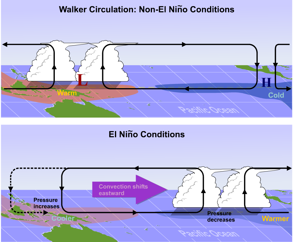
But, since El Niño changes the location of the warm waters in the equatorial Pacific, it alters the Walker Circulation, too. The top schematic above shows the "normal" state of the Walker Circulation, with warm water in the western Pacific causing lower surface pressures there and favoring rising currents of air and convection (showers and thunderstorms). The eastern Pacific, on the other hand, has higher pressures at the surface and is characterized by gently sinking air. In between, the trades transport air toward the western side of the basin near the surface. During an El Niño episode, however, the Walker Circulation is reversed: As water temperatures increase in the eastern and central equatorial Pacific during El Niño, rising air and convection are favored (meaning more showers and thunderstorms than normal). In the western Pacific, where waters aren't as warm as usual (and surface pressures are higher than normal) sinking air is favored (convection is suppressed, meaning fewer showers and thunderstorms than usual).
The changing patterns of showers and thunderstorms associated with the reversed Walker Circulation can bring dramatic consequences. In nations of the western Pacific, a general lack of rain that comes with sinking air can pave the way for drought and wildfires. In the eastern Pacific, typically dry areas can receive a protracted period of recurrent heavy rain during an El Niño, and if the El Niño is strong (sea-surface temperatures as high as three degrees Celsius or more above the long-term average) the onslaught of rain can lead to flash flooding, and widespread destruction.
We can see a prime example of the major changes that El Niño brings by examining the coast of South America from Ecuador southward to northern Chile. This area boasts some of the most extensive coastal deserts on the face of the earth, including the Atacama Desert, which is known as the driest place on Earth. In parts of the Atacama Desert, nary a drop of rain falls for years at a time (check out the bone-dry Atacama Desert from space and on the ground). But, during El Niño, the dryness gives way to showers and thunderstorms that develop in the rising branch of the Walker Circulation, which can drop more rain in one day than normally falls in a decade or more. The heavy rains can result in beautiful desert "blooms," in which the desert floor becomes covered with flowers. The Atacama Desert bloom that occurred during the 2015-2016 El Niño(link is external) was especially stunning.
So, while the Walker Circulation reverses during an El Niño event, just the opposite happens during La Niña. The Walker Circulation actually becomes stronger than its "normal" state during La Niña. Cooler-than-normal waters in the central and eastern Pacific help to increase sea-level pressures in that region even more, and the sinking air overhead becomes even more pronounced. Meanwhile, stronger trade winds continue to mound warm water in the western Pacific, leading to an even more pronounced signal of rising air and showers and thunderstorms there. In other words, during La Niña, typically wet areas in the equatorial Pacific tend to get a bit wetter, and typically dry areas tend to be even drier.
Global Impacts
But, what happens in the tropical Pacific doesn't stay in the tropical Pacific! The impacts of El Niño and La Niña ripple out across the globe largely by way of their impacts on the subtropical jet stream (STJ), which increase the probability that it reconfigures into persistent and distinctive patterns, particularly during the cold season. In turn, this reconfiguration produces ripples that alter weather patterns, called teleconnections. In a nutshell, a teleconnection is a correlation between a persistent weather pattern occurring in one region (in the case of El Niño or La Niña, the eastern and central equatorial Pacific) with recurrent weather patterns in other regions of the world.

So, how can El Niño or La Niña impact the STJ? I'll focus on El Niño for simplicity. As it turns out, over the course of several months, the warm waters of El Niño modify the overlying air columns, making them a bit warmer than normal, too. For example, check out the temperature anomalies near the top of the troposphere from January to March 1998 (during a strong El Niño). It's pretty clear that the warmth of El Niño had been transferred all the way to the upper troposphere, with a large area of warmer than normal air in the central and eastern tropical Pacific. These alterations to the temperature patterns aloft also impact the pressure gradients aloft, causing the STJ to strengthen during an El Niño. To see what I mean, compare the long-term average of winds near the top of the troposphere during January - March to those during January - March, 1998 (above). There's no doubt that during the strong El Niño of 1997-1998, the STJ was more robust than normal. Its fastest winds extended farther across the Pacific and it was stronger near the southern United States, too.
Changes to the STJ over months can lead to recurrent weather patterns that cause areas of extreme weather across the globe. For example, in winter, a stronger STJ can play a more active role in the development of mid-latitude cyclones, which can cause recurrent storminess in California and along the southern tier of the United States (and sometimes up the East Coast, too). Frequent visits from strong mid-latitude cyclones can also lead to more active tornado outbreaks along the Gulf States and Florida during El Niño winters. But, there are many more teleconnections! To see what I mean, check out these graphics showing typical large-scale temperature and precipitation anomalies that accompany El Niño and La Niña during Northern Hemisphere winter and summer. In North America, during winter, perhaps the most striking effect of El Niño is a large warmer-than-normal area from Alaska stretching across western and central Canada into the northern tier of the United States. The southern United States, on the other hand, tends to be cooler-than-normal (especially the Gulf States) and wet, which fits with the active parade of mid-latitude cyclones that can trek across the southern U.S. during El Niño winters.
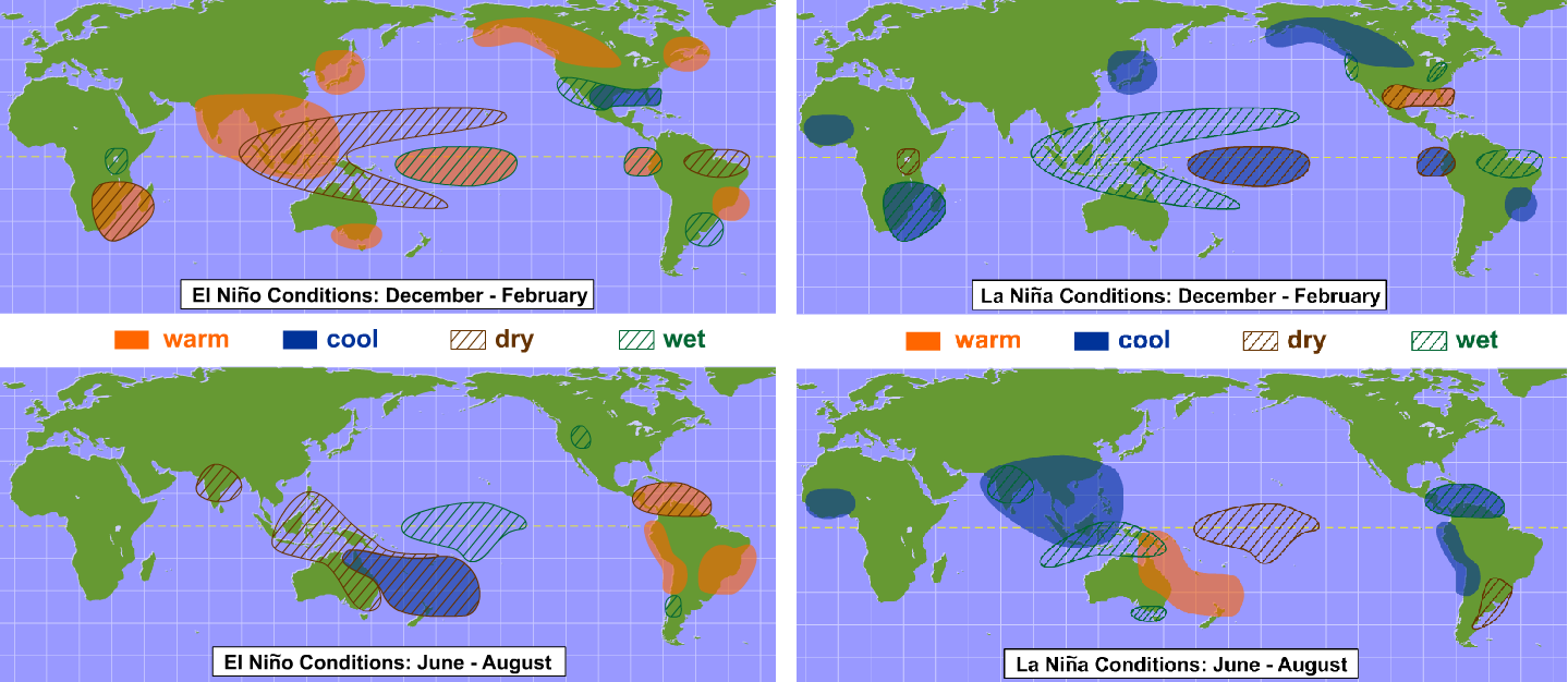
Also note that in some areas, the effects of La Niña tend to be largely the opposite of the effects of El Niño, which makes sense because La Niña is the opposite of El Niño. But, in some areas of the world (more commonly in Northern Hemisphere summer, when El Niño and La Niña tend to be weaker), their impacts bear no resemblance to each other at all. So, La Niña's teleconnections aren't always as simple as assuming the opposite of whatever happens in a particular area during an El Niño. The atmosphere is more complex than that!

Still, knowing the state of the tropical Pacific can help weather forecasters with long-range weather outlooks(link is external) (say, for a month, or a particular season) in other parts of the world. But, even knowing that an El Niño or La Niña is present offers few complete guarantees. To understand why, allow me to use an analogy. Have you ever thrown rocks into a pond and watched the waves that each rock's splashdown creates? Bigger rocks make bigger waves, and if you throw multiple rocks, interesting things happen when ripples from different rocks encounter each other. If you throw enough rocks into the pond, eventually it's virtually impossible to attribute the waves reaching the bank of the pond to any single rock because the interactions are too complex.
And so it is with the atmosphere. Indeed, a barrage of "rocks" thrown into the pond of air we call the atmosphere determine weather patterns across the middle latitudes, including the distribution of continents and oceans, mountains, the extent of ice and snow cover, and, yes, El Niño and La Niña. So, please understand that no single storm can be blamed on El Niño or La Niña. Such an assignment of blame is tantamount to attributing a ripple of water reaching the side of a stone-infested pond to a single rock. Could El Niño or La Niña play an important role? Of course, with the stipulation that strong El Niños and La Niñas play more pivotal roles in fashioning hemispheric and global patterns of weather (metaphorically, strong El Niños and La Niñas are bigger rocks that make bigger splashes that produce bigger ripples). But, El Niño or La Niña does not single-handedly take over the atmosphere and dictate a snowstorm here, a drought there, and so on and so forth. They merely make certain weather patterns more (or less) likely than usual over the course of months or seasons.
Furthermore, no two El Niños or La Niñas are exactly alike, so any single El Niño or La Niña may not produce temperature and precipitation patterns exactly like the idealized graphics I showed you (the Gulf States aren't always cool and wet in the winter during an El Niño, for example). The strength of the El Niño or La Niña matters, as does the specific location of the largest sea-surface temperature anomalies in the tropical Pacific. Furthermore, El Niño or La Niña is just one "rock" being thrown into the atmospheric pond. While forecasters can use knowledge of El Niño or La Niña teleconnections to help them make long-range outlooks for a given month or season, other atmospheric features can mask the influence of El Niño or La Niña entirely. In other words, sometimes there are bigger rocks making bigger splashes in the atmospheric pond, which makes long-range forecasts very challenging! But, make no mistake about it, whenever you see a long-range weather outlook, most likely the forecasters who prepared it incorporated the state of the tropical Pacific into their forecast rationale. So, El Niño and La Niña are certainly important factors on a global scale! They can even affect tropical cyclone activity, which is one topic we haven't explored in this lesson. That's because tropical cyclones deserve their own lesson (up next)!