Activity: US Census Geographies and population data. Create and compare reference maps of various Census geographies of your hometown/neighborhood
Let’s start with the geographic coverage or the “where” of a problem. People have many ways of describing their environment, hometown, and surroundings. Terminology ranges from colloquial references to specific definitions in gazatteers.
- Regions, designated areas, tracts
- Census geography – neighborhoods, blocks
- Hot spots, corridors, areas of influence
The U.S. Census Bureau establishes a hierarchy of geography in the main Census website (www.census.gov(link is external)) and advanced search methods of census data:

U.S. Census Entities and Descriptions - understanding geography.
Urbanized Area - A continuously built-up area with a population of 50,000 or more. Urbanized areas are defined as densely developed territory to provide a better separation of urban and rural territory.
Census Tract - A statistical subdivision of counties; serves as framework for assigning census block numbers. Small, relatively permanent subdivision of a county or equivalent entity (e.g., district, parish, canton). Generally has a population size between 1,200 - 8,000 people.
Block Group - A statistical division of census tracts, generally containing 600 - 3,000 people. These are used to present data and control block numbering. Block groups consist of clusters of blocks within the same census tract that have the same first digit in their 4-digit census block number.
Blocks or Census Blocks - The smallest Census Bureau geographic entity. Generally bounded by visible features such as streets, streams, railroad tracks, legal or statistical entities. Census blocks nest within all other geographic entities; serve as the basis for all tablulated data.
Note:
If you're feeling a little "rusty" with regard to Census geography, here are some resources:
- You may want to look up the definition for each of the boundary features in step 3 below—use the US Census "2010 Geographic Terms and Concepts(link is external)" resource (continues as a current reference in 2024).
- In 2020, the U.S. Census Bureau decomissioned it's American FactFinder statistics and information search engine. The new site to explore Census data is found at data.census.gov(link is external) where citizens and researchers can still find: American Community Survey, Decennial Census results, population and housing unit estimates.
- For a more in-depth study of boundary features, refer to Chapter 2 of the "Geographic Areas Reference Manual (GARM) — 1990 Census(link is external)." It is a bit dated, and you'll find that some definitions differ from those currently used for the 2010 Census, but the GARM does a nice job of contextualizing Census geography. The diagram on pages 2-9 of Chapter 2 provides a nice visual understanding of how small-level boundaries nest.
- There is a wealth of other resources at the "Resources for Understanding Census Bureau Geography.(link is external)" I've linked to some of these resources in the Lesson 2.2 Readings - Census Geography and Attributes page in Canvas.
Step 1. Exploring Census Data.
Remember that the U.S. census has been conducted every 10 years since 1790 as required by the U.S. Constitution. In addition to that data, the Census Bureau conducts a number of surveys annually that pull together a great deal of information about the nation that is vital for government programs, policies, and decision making. Census data is available in a number of formats such as: thematic maps, reference maps, shapefiles, KML's, table data, as well as other types. We will begin by walking you through a simple data search in order to get you more familiar with the process of finding census data. As you are working with the site, pay close attention to the datasets and formats that could assist you in a particular interest or future project.
a. Navigate to the Explore Census Data(link is external) at the US Census Bureau's website (data.census.gov).

This search bar "Explore Census Data" works best using keywords: e.g. geography, places, data table ID, NAICS code.
Enter: Centre County, PA
b. The next page starts with All Results: Tables, Maps, Profiles, Pages (along the top banner).

c. Click in the Blue Box "Explore Data Centre County, Pennsylvania Profile".

You can see the image is zoomed to the area of interest. This is a great place to start for popular information in one snapshot.
d. Scroll down in the data entries for Centre County.
Left Menu - Topics of Interest Right Menu - Data and Table ID's
(pause while the page is loading, give it time to complete)
Select: Income and Poverty > Scroll down on the right to Employment and Labor Force Status
Note that this is Table DP03 (Data Profile 3), you will search on this Table next.
Step 2. Selecting the Data Table.
a. To go back to the United States Census Bureau(link is external) landing page, click the logo at the top left > Explore Census Data.

Enter: DP03 > click DP03: SELECTED ECONOMIC CHARACTERISTICS (TableID DP03 is the "Data Profile 3")
b. Select the Tables tab and Tables on the left menu. By default, data is for the entire United States.
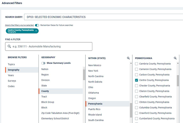
Step 3. Drill Down in Geography.
a. To drill down in Geography and compare data in a hierarchy of geographic entities, select Filter (in Table Results) of the left menu. Use the check boxes for specific geography selections.
Geography > County > Pennsylvania > check Centre County, Pennsylvania
also select
Geography > State > check Pennsylvania
also select
Geography > Zip Code Tabulation Area (ZBTA) > 16802 (State College, PA) for demographic information at the zip code level
b. Done with geography selections, click the chevron at the top right to hide the Geography topic menu
Step 4. Selecting a Census Product.
a. American Community Surveys (ACS) are 1-Year Estimates which provide data on a selected geography with a population >= 65,000 people. For more information on the ACS, reference Understanding and American Community Survey Data Tables(link is external) (US Census Bureau, 2024).
b. The ACS 5-Year Estimates cover all geography in the United States and Territories.
> select the latest ACS 5-Year Estimates Data Profiles
c. Examine the data you have selected (perform Exploratory Data Analysis - EDA)
> select Customizable Table button, then
> Columns of Estimated totals, Percent of Population, and Margin of Error by geography (PA, Centre County, Zip 16802, State College)

d. This table is customizable:
Turn off Margin of Error, click +/- Margin of Error
Use Hide to unclick columns, e.g. you could unselect Estimate and leave Percent checked to view a percent of the Population rather than estimated totals.
Click the '>' or 'V' symbol (expand category) before Topics to expand or collapse information
Change the width of columns to your choice of layout or style
Export to CSV, Excel, or PDF; Print first page of data and/or table notes
Your result may look like :

Step 5. Analyze Demographic Data by ACS Topic and Geography.
a. Comparing statistics between Pennsylvania, Centre County, and State College
| Topic | Criteria | Pennsylvania | State College |
|---|---|---|---|
| Employment Status | Population >= 16 | 10.638,892 | 12,700 est. |
| Occupation | Service Occupations | 16.5% of workforce | 35.1% |
| Industry | Education, Health Care | 26.4% of workforce | 36.9% |
| Class of Worker | Government | 11.2% of workforce | 18.7% |
b. You could also add other zip codes in State College or the surrouding area to examine differences in economic data and factors. Changing the Employment Status and age groups introduces perspectives on demographics, citizens, sources of tax revenue, and possibly commuting patterns. A closer examination of the Industry criteria adds statistics of sectors of the economy, data on retail vs. University employment, and can be matched to other economic features.
Concluding Thoughts.
As you create maps, pay close attention to the actual geography these boundary features represent. We'll delve into this topic more thoroughly later in the course, but consider:
- Which boundary best represents what I think of as my "neighborhood"? Which boundary best represents what I think of as my "region"?
- Choose one boundary feature and consider, with attribute data captured at that level, for what purpose might it be useful? For example, what level of detail might I want to consider if I were planning to open a store?
- What considerations might I have to take into account when using data from a particular boundary feature?
- Consider the differences in what people think of and what geographic entities are available in the US Census database when you are showing a "neighborhood," a "region," "trade area," or "sales territory," etc. Keep in mind, we'll come back to geographies and scale throughout the course, and you'll likely refine your understanding.
Jot some notes as you work through these questions.