Coastal Processes, Hazards, and Society

The 1700 Cascadia Megathrust Earthquake and the Future of Cascadia Margin

PrintPrint

The 1700 Cascadia Megathrust Earthquake and the Future of Cascadia Margin

The 1700 tsunami that impacted the Puget sound region was triggered by a megathrust earthquake off the coast of northern California, Oregon, Washington, and British Columbia on the so-called Cascadia margin. The event happened on the evening of January 26th as documented in Japanese historic records. In Japan, the event was called an “orphan” tsunami because the earthquake was so far away it was not felt. The other significant piece of evidence for the tsunami comes from dead trees in so-called “ghost” forests in Oregon and Washington that can be dated using carbon 14 and tree ring studies. These trees in lush coastal forests are thought to have been instantly killed by the saltwater when they were flooded initially by up to 12 m (36 feet) of land subsidence associated with the megathrust earthquake and then by the tsunami. The photo below shows the Neskowin Ghost Forest on the Oregon coast. We see many tree stumps sticking up above the sand at low tide. These trees were killed by a tsunami in 1700 when the elevation of the land fell, and they were completely inundated and then buried by sand. Large storms eroded the sand from the trees and exposed them. They remain as evidence of the huge tsunami more than 300 years ago.
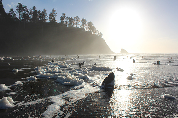
Tree stumps protrude from beneath the water along a wooded coast.
Stumps of trees at the Neskowin Ghost Forest, Oregon

Oral accounts from indigenous Native American and First Nation tribes living on the coast of Vancouver Island in Canada that have been passed down from generation to generation tell of an earthquake and tsunami on a winter’s evening. The accounts describe that all the low-lying settlements were wiped out and the only survivors were those people who lived 75 feet above the waterline. So the tsunami must have been massive!

Subsidence and tsunami records suggest that the earthquake was in the range of a magnitude 8.7-9.2 on the Richter scale. So what is a megathrust earthquake? It’s a very powerful quake usually close to or greater than a magnitude 9. These quakes occur at subduction zones where one plate is thrust under the other. When this happens the overriding plate moves upwards rapidly and this is what typically generates the tsunami. What is incredible about these events is the motion covers such massive areas. In the 2004 Indian Ocean event, an area 180 km wide and 1000 km long moved up by 30 meters! In the 2011 Tohoku event, an area 200 km long by 500 km wide moved up by 20 meters!

Back to Cascadia. The whole margin from Northern California to British Columbia lies about 200 km from the plate boundary where the Juan da Fuca Plate is sliding beneath the North American Plate. Paleoseismology, the exploration of evidence of ancient quakes from rocks, has become a cottage industry here and suggests that a major (i.e. megathrust) quake occurs every 500 years on average. So it’s been 300 years since the 1700 event and thus getting close to the time for another major event. The probability of such a massive quake in the next 50 years is about 12 percent, about 1 in 8, which is not insignificant.

Cascadia earthquake sources map
Tectonics of the Cascadia margin
Credit: Cascadia earthquake sources via Wikimedia (Public Domain)
Click here for an explanation of the Cascadia earthquake source map..

Cascadia earthquakes are triggered by the movement of North American and Juan de Fuca Plates and to a lesser degree the Pacific Plate. The motions cause shallow and deep earthquakes, some that have epicenters on the land and do not cause tsunami, and others that have epicenters in the ocean. These oceanic earthquakes, like the 1700 Megathrust Earthquake, have the potential to trigger large tsunami that arrive at the coast of Oregon and Washington in 15-20 minutes. This quake provides a warning for the future.

The map shows that there were crustal earthquakes in Washington in 900AD and 1982, deep earthquakes in 1949, 1965, and 2001, and a subduction zone earthquake in 1700. The following chart appears below the map:

Cascadia Earthquakes
Source Affected Area Max. Size Recurrence
Subduction Zone W. WA, OR, CA M9 500-600 yr
Deep Juan de Fuca plate W. WA, OR M7+ 30-50 yr
Crustal faults WA, OR, CA M7+ hundreds of yrs?

This is the scenario that could play out on the Cascadia margin. A magnitude 9 earthquake rocks the plate boundary leading to a 1000 km long rupture including significant vertical displacement. This generates a tsunami that travels at 800 km/hour. Folks on the coast will feel the earthquake waves first with a magnitude between 7 and 8. This severe shaking will crumble older buildings with poor construction, collapse bridges, and cause landslides and soil liquefaction (when waterlogged soils behave like Jello---see images below from Alaska of the potential damage from liquefaction), stranding communities, and hampering relief. But everyone on the coast will know that the worst is yet to come and that they will need to evacuate as soon as the land stops shaking. The deformation that occurs along the plate boundary could cause land at the coast to sink by up to 6 feet (2m) making the coastal zone much more susceptible to flooding. The first tsunami wave will reach the coast from Victoria Island in Canada to Northern California in 15-20 minutes giving folks very little time to escape to higher ground. The waves could be 30-40 feet (9-12 m) in height when they hit the coast but some models suggest they could reach 100 feet (30 m), and in many parts of the coast they would flood up to 10 miles (16 km) inland. Some parts of the coast are a lot more vulnerable to tsunami inundation than others, and citizens in these locations will have to move to higher ground extremely rapidly once the earthquake waves subside. The waves will keep coming and since they have such long wavelengths it will take hours for the water to subside.

Earthquake Damages

Video: The Next Cascadia Earthquake: Worst-Case Scenario (8:07)

The following video describes the likely impact of a megathrust Cascadia earthquake.

Click here for a transcript of The Next Cascadia Earthquake: Worst-Case Scenario Video.

PRESENTER: On January 27th, 1700, Japanese chroniclers reported a mysterious wave, which struck the island of Honshu and caused widespread damage. The records referred to it as an orphan wave, because unlike most tsunamis on record, it had struck seemingly out of nowhere without being preceded by a detectable earthquake.

[MUSIC PLAYING]

About 12 hours earlier and more than 7,000 kilometers away on Vancouver Island, several villages of the Hesquiaht First Nation were completely destroyed while the inhabitants were sleeping. And 300 years later in 1986, paleontologists excavating along the Washington coast discovered a ghost forest of hundreds of trees that had all been killed by being suddenly submerged in saltwater. The orphan wave, the lost villages, and the ghost forest all had the same cause, a massive earthquake along the Cascadia subduction zone where the Juan de Fuca tectonic plate is being forced under the North American plate.

Further research has shown that there have been seven major earthquakes in the Cascadia subduction zone in the last 3,500 years with the time between major quakes ranging from 200 to 900 years. More than 300 years have passed since the quake of 1700, and the region has grown into an economic center home to more than 10 million people. We need to ask, what would happen if the next Cascadia earthquake happens tomorrow?

This is a worst-case scenario, and the odds of it happening in the near future are still quite low. It's been estimated at around a 12% chance in the next 50 years. But it's a real possibility. So let's imagine what would happen in the worst-case scenario for the next great Cascadia earthquake.

For this scenario, we're going to look at the impact of a magnitude 9.0 earthquake occurring on a weekday morning in late spring. Throughout the region, people are beginning their days. Students are arriving at school. And in the major cities of Vancouver, Victoria, Seattle, and Portland, businesses are gearing up for another normal workday. The major seaports and airports in the region will handle more than 200,000 passengers and $600 million worth of cargo by the end of the day.

At around 10:00 AM, after more than two centuries of building pressure, the Cascadia fault line finally slips and a 1,000-kilometer-long section of the North American plate moves 20 meters to the west, causing one of the largest earthquakes to strike the continent in more than half a century. Seismic waves race outward from the epicenter at 5 kilometers per second and reach the coast before moving inland. This means that people living far enough inland will start seeing posts about the earthquake on social media seconds before they feel the shaking start.

In order to understand the effect that the earthquake will have, we need to understand two different measurements-- magnitude and intensity. Magnitude is the measure of how much energy is released by an earthquake. A magnitude 9 earthquake like this one will release more than 2 exajoules of energy, equal to almost half a billion tons of TNT.

Intensity is a measure of how violent the shaking is at any given point. And here we actually get some good news. Since the epicenter of the quake is more than 100 kilometers off the coast, most cities will experience less violent shaking than other recent earthquakes. Here's an intensity map for the Northridge earthquake, which struck California in 1994, compared to an intensity map for a hypothetical magnitude 9.0 earthquake. The two big differences are that the Cascadia earthquake will be felt over a much wider area and it will last for much longer. The Northridge earthquake lasted for 20 seconds. The Cascadia earthquake will last for more than four minutes.

To get an idea of the impact that the quake will have, let's take a closer look at one of the largest cities in the area, Seattle, Washington, with a population of around 700,000. The intensity of the quake in this area is between a 6 and a 7 on the Mercalli intensity scale, which is associated with mild to moderate damage. Most of the large and recently built buildings in the city sustained fairly little damage.

Of greater concern is the 1,100 unreinforced masonry buildings in the city with more than 30,000 occupants. These buildings pre-date the current codes, and most of them haven't been retrofitted. Many of these buildings are prone to collapse. And those that don't collapse might cause injuries as a result of falling debris. Other risks facing the city include soil liquefaction, where areas of wet soil begin to behave like a liquid during an earthquake and cause damage to roads and foundations.

Thousands of landslides occur across the city, blocking roads and damaging buildings. Landslides, building collapses, and soil liquefaction occur throughout the Pacific Northwest. By the time the shaking stops, water, power, and cell service have been lost across most of the region. Nearly 1,000 highway bridges and overpasses have collapsed or are rendered unusable, cutting off-road access for dozens of communities. And the worst is still yet to come.

When the fault line slipped, it displaced billions of liters of water, creating a wave that begins to radiate outwards at 800 kilometers per hour. People living along the coast will have around 20 minutes to react. For those that have limited mobility or are cut off by damaged roads and bridges, options will be very limited. The height of a tsunami depends on the shape of the coastline. Because of the steep coasts in the region, the tsunami won't be as high as some other recent ones. However, at 10 to 15 meters, it's still high enough to completely inundate low-lying coastal communities and cause flooding up rivers more than 50 kilometers from the coast.

Over the next several hours, the wave will radiate outwards across the Pacific and cause damage as far away as Alaska, Hawaii, and Japan. Aftershocks continue possibly for months after the initial quake. Relief efforts are almost immediately mobilized from all levels of government, but they'll have their work cut out for them. It's immediately apparent that this has been one of the worst disasters to strike the continent in recent history.

Hundreds of thousands of buildings have been destroyed or damaged beyond repair. More than 100,000 people are left homeless, with many more being displaced. Up to 10,000 people might be killed. Around 70% of the deaths and injuries are a result of the tsunami, with the remainder being caused by collapsing buildings and falling debris. This would be the deadliest disaster to hit the United States or Canada in more than a century.

The cost is difficult to estimate, but the immediate cost could exceed $150 billion, making it one of the most expensive natural disasters in recorded history. The long-term economic impact could easily double that as the ports, airports, and corporations based in the area have their services interrupted for months.

Recovery is a long process. Efforts are focused on restoring essential services to population centers first. Seattle and Portland have their electricity and water fully restored after about six weeks. Meanwhile, the hardest-hit areas along the coast and isolated communities inland may be left without road access, utilities, and health care for up to three years after the quake. Thousands of the people who have been displaced may never return home.

The odds of this scenario occurring in the near future remain fairly low. But earthquakes are an inevitability, whether they happen a year from now or not for another century. So what's being done to prepare for this scenario? Funding has been allocated to bring thousands of vulnerable buildings, highways, and bridges up to code. But the process will take years or decades. Improvements have also been made to early warning systems.

With efforts from all levels of government and improvements to disaster preparedness and education, we have the best possible chance of preparing the Pacific Northwest for the next major earthquake. I've included links and resources in the description as well as links to the studies which were used to make this video. If you have ideas for future videos, leave a comment. And if you'd like to see more videos like this, click here to subscribe.

Such a disaster will happen along the Cascadia margin at some time in the future. The damage and impact will depend on the mechanics and location of the quake, the amount of coastal subsidence, the amount of damage by the earthquake, and the height of the tsunami waves. The good news is that public awareness is significant. There has been a lot of media attention and local governments have been investing heavily in public safety projects.