Stratigraphy
The earlier text says that the Entrada Sandstone is from near the middle of a time we call the Mesozoic, an Era of geologic history, and for Bryce, our text told you that Bryce Limestone is from early in the Cenozoic Era of geologic time. You have not been asked to learn these terms yet (but you will be, so you might want to lodge them in your brain now). The Mesozoic is older than the Cenozoic, so the Entrada is older than the Bryce. How do we tell which layers are older or younger?
Putting rocks in order is an enjoyable puzzle requiring the logic used in sudoku or crossword puzzles. You rely on a few general principles that boil down to common sense, plus a lot of puzzling, looking, and thinking. Start with “What’s on top”? As we saw with Hurricane Katrina in New Orleans, the layer of mud that settles out of floodwaters is deposited on top of the mud, grass, floor tiles, and grand pianos of the floodplain. Naturally, the mud from the next year's flood is deposited on top of the mud from this year (nature doesn’t clean off the grand piano). In ordinary sedimentary rocks, the youngest rocks are on top and the oldest are on the bottom. We call this the Principle of Superposition.

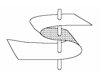
Note that this applies to ordinary rocks. There are cases in which rocks are turned upside down. Take a sheet of paper on your desk, put your fingers on opposite sides, and squeeze your fingers and the ends of the piece of paper towards each other (see the figure above). The paper will buckle into a fold. If you can get your fingers close together, the fold may “fall over”. A vertical hole through your paper would now go through the top of the page and out the bottom, then through the bottom of the page and out the top, before finally going through the top and then the bottom—going from top to bottom, the paper is right-side up, then upside-down, then right-side up (look at the figure again).
Fortunately, many “up” indicators in rocks tell you which way was up when the rock was formed. Animal tracks and raindrop imprints are made down into mud, not up. If you find a track pressed up into the roof of a cave, it is reasonable to suppose that the track originally went down but then has been turned over, so it is now upside-down. (Bats can hang from the ceiling, but dinosaurs did not walk upside-down on cave ceilings!) Mud cracks get narrower going down and disappear at the bottom, not the top. Curved clam shells are usually flipped by currents into the stable, hollow-side-down configuration, rather than the rocking, hollow-side-up configuration. Bubbles in lava flow rise to the top where they are trapped just beneath the quick-cooled upper surface; the bubbles do not sink down to the bottom. (We saw a little of this with the dinosaur track and mud cracks in the picture on the Bryce page, and you will meet more of this in the Rockin' Review of this chapter and also in Exercise 4. So if you are having trouble visualizing any of it, stay tuned for more.) Hence, you can learn whether the rocks have been turned upside-down or not.
In clastic sedimentary rocks, the clasts must be older than the rock. So a conglomerate containing pieces of granite and other things tells of the formation of granite from melted older rock, followed by physical erosion to break the granite into pieces, followed by transport to mix the granite pieces with chunks of other rocks, followed by deposition of the chunks followed by hard-water cementation to make the conglomerate rock. A conglomerate containing pieces of sandstone from a beach tells of two cycles—make the sand from older rocks (perhaps from the breakdown of granite by chemical weathering), followed by transport of the sand to a beach, followed by cementation of the sand with hard-water deposits to make sandstone, followed by physical weathering of the sandstone to make sandstone chunks, followed by transport of the chunks and mixing with others and deposition and cementation to make the conglomerate. In the video with Dave Janesko earlier in this module, a conglomerate contained a clast of an earlier conglomerate that contained clasts of still earlier sedimentary rocks. If a fault has split a granite clast in a conglomerate, and moved one side relative to the other so that the pieces no longer match, the fault must be younger than the conglomerate—something must exist before you can break it. If a layer of sandstone is standing on edge then it must have been deposited, hardened, and then tilted—because of mass-movement processes, layers are nearly horizontal when deposited (not exactly, but pretty close); if you tip a mud layer up on end before it has hardened, it spreads into a new, nearly horizontal layer.
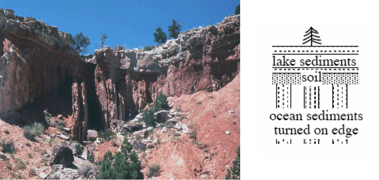
Below is a photograph of an outcrop near I-70 in the near-desert conditions of central Utah (shown on the left), and a sketch of the outcrop (shown on the right). The rocks at the bottom were deposited on a sea coast—they contain marine fossils and other markers of the sea and are mostly sandstone and shale. But they are standing on edge and truncated at the top. Developed on the top of them is a soil, and on top of that are lake deposits with flamingo bones, fish fossils, and alligator bones.

The story of this outcrop includes:
- Some history to produce sand and mud and deliver them to the sea, where they were deposited and then hardened;
- A mountain-building episode to turn the rocks up on edge;
- Erosion to truncate the rocks, together with weathering to create the soil;
- Growth of a lake, with sediment accumulation in the lake;
- Drying or draining of the lake; and
- Erosion revealing the cross-section of the deposits that you see.
You can postulate many other things—Dr. Alley is just lying about the rocks; or, the space aliens put the rocks there; or, a giant tornado blew the rocks there one afternoon; or…. We humans are very inventive, and can always come up with a new idea. But when you follow out the implications of these other stories, some fundamental problem always comes up, whereas the story of the rocks being deposited and hardened and tipped on end and eroded and so on works just fine, and makes predictions that are borne out over and over. Hence, the “geological” or “scientific” interpretation is the sensible one.
Notice that the erosion surfaces [events 3 and 6 in the list above] represent time gaps in the sedimentary sequence; the rocks at this site do not have a record of the environment during the time erosion was occurring—you have to go to where rocks were being deposited to learn that. A time gap in a sedimentary sequence, whether from actual erosion or just lack of deposition, is called an “unconformity”. Most of the land experiences erosion most of the time—the mud in the Mississippi is eroded from the lands upstream, and most of us most of the time do not have to worry about mud being deposited on our grand pianos or carpets. But some sediments are deposited somewhere on land most of the time, and sediments are deposited almost everywhere almost all the time under the sea, allowing a fairly complete story to be told.