Prioritize...
When you've finished this page, you should be able to describe sea / lake breeze and land breeze circulations, as well as discuss the synoptic conditions which favor their formation.
Read...
Imagine for a moment that you heard a weather forecast that went something like, "high temperatures today will range from 55 to 110 degrees Fahrenheit" during the summer. Maybe you would think that forecasters were clueless and were just trying to cover their bases. But, are there instances where such a forecast might be an accurate depiction of what will happen? Take a look at the 21Z surface analysis from July 18, 2005 below, and focus on southern California.
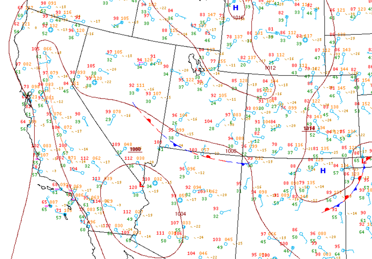
As it turns out, such a wide range in temperatures over relatively short distances in California isn't all that crazy (although I admit that the forecast above could be clarified a bit more). Note on the surface analysis above that temperatures were more than 100 degrees over California's Central Valley, while readings near the coast were in the 50s and 60s! Over distances of roughly 100 miles, temperatures varied by some 50 degrees! Even with such huge temperature contrasts in place, there was nary a thunderstorm to be found in the region (which is often the case during the summertime in southern California). Think about that next time you hear a weathercaster explain severe thunderstorms as a result of the "clash of warm air and cold air." If that was really the case, we'd get thunderstorms all the time in southern California during the summer (which doesn't happen). "The clash of warm air and cold air" is really a rather poor explanation of the cause of thunderstorms, but I bet you've heard it before (or will now, if you listen for it).
That aside, how do such huge temperature contrasts develop over California in the summer? The answer is the "sea breeze." While the interior of California bakes under the summer sun, coastal locations routinely stay in the 50s or 60s as cool sea breezes blow inland from chilly offshore waters.
The Meteorology of Sea Breezes
For the record, a sea breeze is a mesoscale, onshore wind system that develops near the coast in response to the differential heating of a land mass and the adjacent, relatively large body of water. Based on empirical studies, the daytime temperature difference between land and water must be at least six degrees Fahrenheit in order for sea breezes to develop, assuming that the background synoptic-scale pressure gradient is weak. That's because relatively strong synoptic-scale winds disrupt the development of sea breezes. As a general rule, the greater the temperature difference between land and sea, the stronger the sea breeze.
Let's start to build our conceptual model of a sea breeze. Climatologically speaking, sea breezes typically develop along the U.S. Coast from spring to autumn (essentially the warm season). As the land heats up after sunrise, the overlying air becomes considerably warmer than the lowest layer of air over coastal waters. In response to this differential heating, the heights of constant pressure surfaces rise near 925 mb rise (see Step #1 on the idealized schematic below). With higher heights (higher pressure) aloft, air flows toward the sea at higher altitudes, creating weak divergence that helps to lower the surface pressure over the land (Step #2). Air aloft moving away from land eventually converges over the sea, causing surface pressure to increase over coastal waters (Step #3). The resulting mesoscale pressure gradient near the earth's surface now drives cooler maritime air toward land, creating the faithful sea breeze (Step #4). In reality, the facets of the mesoscale circulation you see here develop simultaneously, but I presented the sea-breeze circulation as a series of steps to help you better understand this process.
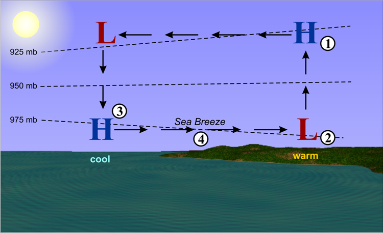
For the record, the typical depth of the sea-breeze circulation ranges from 500 meters to one kilometer. Note that the onshore wind speeds associated with the passage of the sea-breeze front typically fall between 5 and 10 meters per second (10 to 20 knots, approximately). For a visual, check out this schematic showing the size-scale of the mesoscale circulation of air associated with a sea breeze.
For a mesoscale sea-breeze circulation to develop, the "background" synoptic-scale pressure pattern must be relatively weak, because relatively strong synoptic-scale pressure gradients will overwhelm sea-breeze circulations. In a nutshell, the strength of the "headwind" associated with synoptic-scale winds blowing offshore is crucial to the formation of the sea breeze. If this headwind is too strong, the sea-breeze can't advance inland, and the mesoscale boundary that marks the leading edge of the sea breeze, called the sea-breeze front, blows out to sea. If there is too strong a tailwind (synoptic-scale easterlies along the east coast of Florida, for example), the sea-breeze front races inland and is quickly loses its identity to heating and mixing.
With a weak synoptic-scale pressure gradient, the sea-breeze front can advance inland and low-level convergence along it can help spawn thunderstorms (assuming parcels make it to the LFC, of course). As a general rule for the Southeast and Middle Atlantic Coasts of the United States (including Florida), sea-breeze fronts form when the synoptic-scale wind speeds are less than 10 knots. If synoptic-scale wind speeds are greater than 10 knots, this prevailing wind overpowers the sea-breeze front (either a "blow-out" or the front is lost to heating and mixing as it races inland).
Ultimately, there really is no universal threshold speed because the formation of the sea breeze also depends on the temperature difference between land and sea. Although rather crude, a tool that forecasters sometimes use to predict the onset of a sea breeze during the daytime is the ratio of the square of the speed of the geostrophic wind to the temperature difference between land and sea. When this ratio is less than 5 (the "background" synoptic-scale wind is relatively weak and the temperature difference between land and sea is relatively large), expect a sea breeze to form.
The coastlines of huge bodies of water like seas an oceans aren't the only areas that experience sea breezes. Indeed, lake-breeze fronts along the Great Lakes and even smaller bodies of water form in much the same way as sea-breeze fronts (via the differential heating of land and water). For the most part, lake-breeze fronts are a smaller-scale version of the sea-breeze front (lake-breeze fronts are also shallower than sea-breeze fronts). At the small end of the scale, even river-breeze fronts can develop, as this visible satellite image from 1954Z on July 7, 2011 shows. This image shows two river-breeze fronts that developed on each side of the flooded Missouri River in parts of North Dakota and South Dakota. The "veins" of clear skies mark the areas where cool, stable air inhibited cumulus cloud development. Of course, river-breeze fronts can only form in environments characterized by very weak synoptic-scale pressure gradients (check out the 18Z surface analysis).
Land Breezes
Approximately one to two hours after sunset, the temperature difference between land and sea reverses and a land breeze forms. Land breezes are usually weaker than the daytime sea breeze because nighttime contrasts between land and sea are typically smaller. At night, thunderstorms sometimes erupt offshore in the zone of low-level convergence along the land-breeze front. For example, check out this early morning satellite image of thunderstorms along a land-breeze front just off the west coast of Mexico and Central America on September 8, 2001. You can also see the footprint of a land-breeze front off the west coast of Africa on December 17, 2006 (weak convection paralleling the coast marks the position of the land-breeze front).
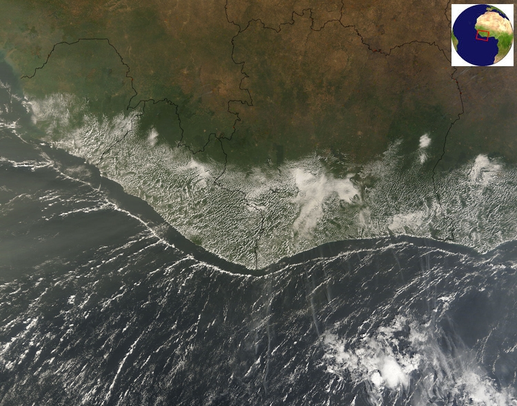
I note that the time of the satellite image above is 1055Z, which is clearly daytime in this part of the world. In a nutshell, there can be simultaneous land and sea breezes in mid-morning (especially in the tropics and subtropics). Although the sea breeze was yet to develop along the west coast of Africa at 1055Z, the persistence of the land breeze into mid-morning is not unusual at these relatively low latitudes.